Trails across Wyoming: The Oregon, Mormon Pioneer and California Routes
Whether it was Manifest Destiny, itchy feet, religious freedom, conquest, breathing room, riches, adventure, the desire to “see the elephant,” draft-dodging, cheap land or other motivations, 19th-century America looked to the vast expanses of the West to ease its national growing pains. The bold took what most acknowledged as the journey of a lifetime and headed west. Long-used trading and hunting routes blazed by American Indians and fur traders soon were worn deep and wide by the passage of thousands of wagons and perhaps millions of animals.
The Oregon, Mormon Pioneer and California trails all cross Wyoming in the central and most popular corridor of this migration. The trails followed the North Platte and Sweetwater rivers west to South Pass, after which they divided into various routes bound for Oregon, Utah or California. As many as half a million people may have traveled this corridor in the 19th century. To many, the environments of the Great Plains, Rocky Mountains and Great Basin seemed like another planet, full of strange and alien landscapes.
Emigration routes were scouted by trappers, traders, the military and early pioneers in the 1810s-1840s. As the West was settled, destinations multiplied, necessitating a complex network of routes. Emigrants sought out better routes as the immense traffic on the main routes strained natural resources of the fragile steppes and desert. Isolated wagon tracks across the West quickly grew into a far-reaching capillary system.
The Oregon/Mormon Pioneer/California Trails have been studied and assessed according to the National Trails System Act of 1968 and have been designated as National Historic Trails. Designation as a National Historic Trail (NHT) is essentially an honorary distinction, providing little protection for any of the routes. However, this identification does expressly recognize the national significance of these routes and allows the federal government to assist with studying and educating the public about these important places. The act further allows the federal government limited authority to acquire portions of these trails from willing sellers.
The Oregon NHT describes the primary routes used between 1841-1848 to emigrate between Missouri and Oregon, although there was traffic along these paths before 1841 and well after 1848. The designation suggests there are roughly 2,000 miles in this route. Some of the greatest usage of these roads occurred during the Civil War period (1861-1865) as the trails swelled with homesteaders and those avoiding conscription. Emigration along this route by covered wagon was recorded into the 1920s.
The Mormon Pioneer NHT commemorates the 1846-1847 migration of the Mormons from Illinois to Salt Lake City, Utah. Some of these routes were used by Mormons to make their trek—“gathering to Zion,” they called it—as late as 1868. The length of the designated trail is estimated at 1,300 miles. The routes taken by the earliest Mormon companies were almost completely within existing segments of the Oregon and California trails. The pioneer Mormon companies of 1847, for example, completed the backbreaking work begun a year earlier by the California-bound Donner Party on the trail through Emigrant Canyon, east of Salt Lake.
The California NHT is a complex of trails that links Iowa and Missouri with California and Oregon. This designation includes major cutoffs and alternate routes and is estimated to include 5,700 trail miles. California was already a major emigration destination before the discovery of gold at Sutter’s Mill in 1848. The next few years saw the heaviest traffic in trail history, and that traffic multiplied the number of paths. Many routes branched off to Oregon as well. The Cherokee and Overland Trails, both of which crossed what’s now southern Wyoming, were omitted from the original California Trail NHT system. These important routes are being considered for inclusion as of spring 2021.
Estimating the lengths of these trails is complicated. Emigrant roads were notorious for flooding, landslides, insufficient grass for livestock, fire damage, avalanches or other impediments to travel. Hence the trails braided into a myriad of alternate routes by which emigrants evaded these problems. Additional complications arose from alternates established in the search for easier, quicker routes. Major physical barriers, such as rivers, playas, hills, ridges, swamps and mountains, often divided the trails into a spider web of interconnecting ruts.
Wagon routes often were chosen for the availability of water and fodder for the beasts of burden whose muscles powered migration. Concerns about the speed of travel sometimes resulted in use of “dry” routes for short segments, chancing that water could be obtained before the livestock died of thirst. Extensive traffic, drought, snow accumulations or wildfires along a particular route could create dangerous shortages of food for the livestock. For these reasons, routes often were associated with important settlements, forts or trading posts.
The South Pass of the Rockies, first discovered by Robert Stuart and his Astorians in November of 1812, was the great gate through which the bulk of emigration flowed. A massive geological event allowed a 20-mile-wide segment of the crest of the Rocky Mountains to slip down between gigantic faults in present southwestern Wyoming, creating South Pass. So gradual was the rise to the Continental Divide at South Pass that many emigrants were unaware they had gone over it until they reached Pacific Springs, almost three miles west of the crest, where the waters clearly flowed westward. John C. Fremont’s 1845 published maps and descriptions of this great gap in the Rockies stirred public interest in this route. In the 19th century “seeing the elephant” was a term that described taking part in a great adventure, or seeing the remarkable. Many emigrants came to consider crossing South Pass the crossing of the elephant’s spine.
While emigrants and their beasts were capable of Herculean feats to overcome steep hills and flooding rivers, the wisest travelers tried to keep heroic efforts to a minimum. Routes were selected that reduced the dangers to the livestock and allowed the animals to pull their loads with the least amount of strain day after day. These trails wind their way through the gentlest portions of rough terrain. While the emigrants chose each route’s position within the landscape, it was the livestock, seeking to reduce their own energy expenditure, that created the precise location of the ruts. A modern visitor to the trail ruts will recognize this by the sinuous pathways worn into the soils.
Emigrants timed their travel to make early use of the spring grasses while avoiding perilous fall snows. Leaving too early meant less food for the livestock. Leaving too late might result in getting trapped in the mountains. Once the journey was begun, travel went at a steady pace, balancing the condition of the animals against the risks of going too slowly. Perhaps the greatest tragedy resulting from slow progress on the trails was the ill-fated Donner-Reed Party of 1846-1847, which took too long negotiating a new cutoff and became trapped by fall snows in the Sierra Nevada mountains. Resorting to cannibalism to survive, the Donners became a prime example of the need for speed.
Overland travel was not for the poor of health or wealth. Outfitting a trip of several months demanded planning, strength, supplies and good luck. There were few markets or stores along the route, especially in the early years. Even in well-supplied wagon companies, the hunting and gathering of food along the way was essential. A burgeoning industry of emigrant guide publications helped would-be travelers decide which routes to take and what to bring.
Before the construction of the transcontinental railroad, emigrants set out from jumping-off places in Missouri and Iowa singly, in small groups and in sprawling trains of wagons and livestock. These assemblages often separated and recombined along the route. Disharmony among travelers often resulted in the splintering of wagon companies and occasional fatal violence. Traveling together offered advantages, especially when confronting equipment breakage, food shortages, security issues, difficult terrain and general emergencies. The military often merged passing emigrant companies into larger trains to provide protection against Indians.
Wagon companies tended to function as mobile democracies or, sometimes, patriarchies. Often companies elected their captains. Some had formal articles to guide behavior of the group. Each company was responsible for providing for its own welfare, laws, security and organization. Crimes committed along the trail were tried by informal courts, with judges and juries selected by the members of the wagon company. Marriages, births, funerals, sharing of resources and assignment of tasks all were managed by the emigrants through their leadership or by direct votes. Some trains, such as Mormon or governmental ones, had a hierarchy and rules imposed by church or other authorities.
By modern standards, the speed of livestock-powered travel along the emigrant roads was glacial, averaging 12-15 miles per day. With great effort and lightening of the loads, ox-drawn wagons could make 20 miles for short periods. Mule and horse trains made better time. At two miles per hour, laden mules might traverse as much as 25 miles in a day. Emigrants generally walked alongside the wagons. Riding was reserved for the sick or infirm. The journey from Missouri to the West Coast usually took several months. When stagecoach service with horse relays became available, coaches and their passengers were likely to cover 60-70 miles per day. On April 3, 1860, the first Pony Express mail run using relays of horses and riders completed the trip to California in an astonishing ten and one-half days.
Travel was dangerous. Diseases such as cholera, measles and smallpox ended thousands of journeys. Accidents, starvation and natural disasters further whittled away at the wagon companies. The threat of violence also hounded them. While conflict with Indians played a large role in the psyche of the emigrants, the travelers were far more likely to suffer at the hands of fellow emigrants or non-Indian occupants of the trail corridor. For example, one of the most substantial losses of life occurred in 1857 at Mountain Meadows in southern Utah Territory when a train of Arkansans was attacked by Utah militia dressed as Indians. It is impossible to know how many emigrants died along the trails. There likely were tens of thousands deaths. Most of those unfortunates lie buried near the trails in unmarked graves.
The list of those associated with events along the emigrant trails reads like a Who’s Who of the history of the West. Many frontier celebrities spent significant time on the trails in Wyoming. Mountain men Jim Bridger, William Sublette, Kit Carson, John C. Fremont— the so-called Pathfinder—and U.S. Army Engineer Frederick Lander, Mormon patriarch Brigham Young, scout and showman William F. “Buffalo Bill” Cody, Gen. George Crook, Gen. Patrick Connor, Crazy Horse, Red Cloud, Chief Washakie, and writers Sir Richard Burton and Mark Twain all played their parts in the trail story.
Wyoming’s Trails
The main routes tell but a portion of the emigrant trail story for Wyoming. The originally established routes were supplemented by numerous additions, and the trail routes also became mail and telegraph routes, military and freight roads. The trail routes influenced the routes of their replacements, the Union and Central Pacific railroads. The Oregon and California NHTs have main routes, with ruts sometimes exceeding 100 feet in width, supplemented by miles of trail braiding, cutoffs, and alternates. Below are a small sample of the cutoffs and named alternates in Wyoming.
Sublette Cutoff—This shortcut, pioneered by Caleb Greenwood in 1844, started near the western margin of South Pass and continued to Fort Hall on the Snake River in present southeast Idaho. The route had an extended dry drive but eliminated the long journey farther south to Fort Bridger. During the California gold rush such cutoffs were especially desirable as gold-seekers often chose time-saving paths.
Hastings Cutoff —This cutoff plays a major role in the story of the famous Donner-Reed Party of 1846-1847. Promoted by Lansford Hastings in the emigrant guide he wrote before the route was scouted, the Hastings Cutoff promised to reduce the trip to California by weeks and many miles. The route, however, is a few miles longer than the regular California Trail routes and its rugged nature created inescapable delays. This cutoff starts near Fort Bridger, Wyo. and rejoins the California Trail west of Elko, Nev. The Donner Party was trapped by snow near Truckee Lake in the Sierra Nevada Mountains and resorted to cannibalism. Roughly half the company died from all causes. Not surprisingly, the Hastings Cutoff was almost completely avoided by subsequent emigration. But the segments blazed by the Donners into what became Salt Lake City were followed in large part by the Mormon pioneer companies of 1847 and became a major thoroughfare to the metropolis.
Cherokee Trail —With the news of the discovery of gold in California, companies of gold miners joined the rush to the gold fields. Avoiding Asiatic cholera, which ravaged the travelers following main trails, several companies of Cherokees from what’s now Oklahoma blazed routes northwest from the Santa Fe Trail to the California Trail in 1849 and 1850. The routes enter Wyoming from Colorado and join the main Oregon-California routes between modern Farson, Wyo. and Fort Bridger.
Lander Trail/Road —Between 1857 and 1858 railroad builder Frederick Lander constructed a wagon road leading directly from South Pass to Fort Hall, Idaho. This route—more than 250 miles long— was one of the first federally constructed roads west of the Mississippi River. The Lander Road was designed, in part, to funnel emigrant traffic away from Salt Lake City and the perceived dangers of attack by the Mormons during the nearly bloodless Utah War of 1857-1858. Lander’s route became a popular alternative to the previously established routes to Fort Hall.
Pony Express Trail —In 1860 and 1861, this fourth NHT-designated trail operated through South Pass. This route also used many of the same ruts as the other National Historic Trails. The Pony Express became one of those iconic events in westward expansion that still captures the American imagination. Its short-lived run ended with the completion of the transcontinental telegraph system.
Overland Trail —In 1862, the Postmaster General of the United States decided to move the overland mail route from the Oregon-California trail along the North Platte and Sweetwater rivers in what’s now Wyoming to a more southern route thought to be less susceptible to Indian attack. This route through Bridger Pass followed segments of the Cherokee Trail system established earlier. The mail route led through Colorado Territory and entered what’s now Wyoming near Virginia Dale, rejoining the main trails near Fort Bridger. Army commanders scrambled to find troops to garrison the stage stations, realizing they had to protect the new route as well as the old trails. In 1865, Indians burned stage stations along roughly 200 miles of the road. They sacked and burned the station and small town at Julesburg, Colorado Territory., twice, despite the presence of a nearby fort. The Overland Trail became a popular emigration, freight and stagecoach route and was used until the completion of the transcontinental railroad in 1869.
There are many other named and unnamed alternates and cutoffs throughout Wyoming, and dozens of stage and freight roads which partially incorporate or otherwise connect with segments of emigrant routes. Like the main emigrant trails, each is a unique and fragile relic of America’s westward expansion.
Resources
- Bagley, Will. So Rugged and Mountainous: Blazing the Trails to Oregon and California 1812-1848. Norman: University of Oklahoma Press, 2010.
- Dary, David. The Oregon Trail: An American Saga. New York: Alfred A. Knopf, 2004.
- Doyle, Susan Badger. Journeys to the Land of Gold. Helena, Mont.: Montana Historical Society, 2000.
- Ecelbarger, Gary. Frederick W. Lander: The Great Natural American Soldier. Baton Rouge: Louisiana State University Press, 2000.
- Fletcher, Patricia A., Jack Fletcher and Lee Whitely. Cherokee Trail Diaries: 1849--A New Route to the California Gold Fields & 1850--Another New Route to the California Gold Fields. Sequim, Wash. Fletcher Family Foundation, 1999.
- Franzwa, Gregory M. The Oregon Trail Revisited. Saint Louis: Patrice Press, 1997.
- Johnson, Kristin, ed. Unfortunate Emigrants: Narratives of the Donner Party. Logan: Utah State University Press, 1996.
- Stegner, Wallace. The Gathering of Zion: The Story of the Mormon Trail. New York: McGraw Hill, 1964.
- Stewart, George R. The California Trail: An Epic with Many Heroes. New York: McGraw Hill, 1974.
- Unruh, John D. The Plains Across: The Overland Emigrants and the Trans-Mississippi West, 1840-1860. Urbana: University of Illinois Press, 1979.
Illustrations
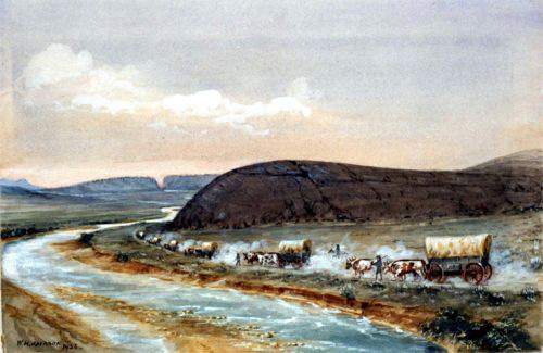
- Pioneer photographer William Henry Jackson, who first traveled the Oregon Trail as a youth in 1866, painted this watercolor of wagons passing Independence Rock in 1936. Courtesy William Henry Jackson Collection, Scotts Bluff National Monument.
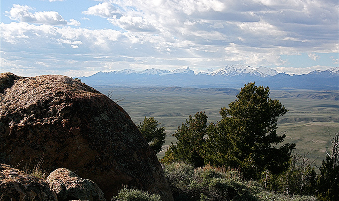
- The photo of South Pass is by Barbara Dobos, president of the Alliance For Historic Wyoming.
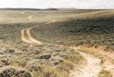
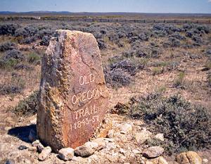
- The photo of the monument at South Pass, placed in 1906 by Ezra Meeker, is by L.A. Jansen. The photo of winding trail between South Pass and Pacific Springs is by Terry Del Bene. All images used with thanks.