Coming to Wind River: The Eastern Shoshone Treaties of 1863 and 1868
In the 1860s, the U.S. government negotiated two treaties with the Eastern Shoshone people that resulted in their taking up a permanent home in Warm Valley—the valley of the Big Wind River and its tributaries—in what is now west-central Wyoming.
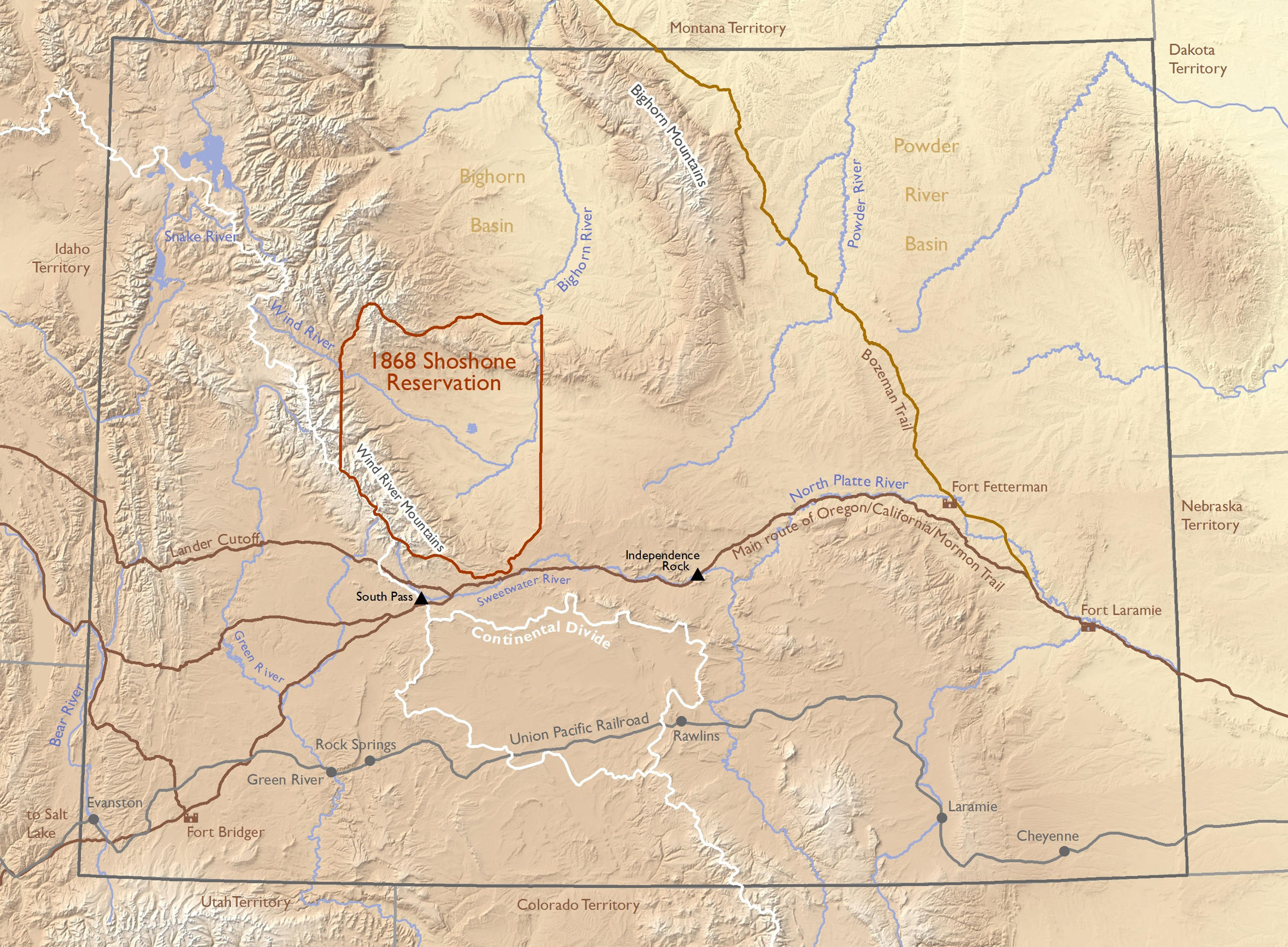
The first treaty, signed in 1863, specified borders for a vast Eastern Shoshone homeland of around 44 million acres, which sprawled on both sides of the Continental Divide. The second treaty, signed in 1868, shrank this to a far smaller reservation—of around 3.2 million acres, with its heart in the Wind River Valley. Seventy more years of land cessions and court cases further reduced the reservation to its present size of around 2.3 million acres.[1] It is now home to two tribes, the Eastern Shoshone and the Northern Arapaho, and since the 1930s has been called the Wind River Reservation.
Between 1778 and 1871, the U.S. government signed more than 600 treaties with tribes. These were similar to any treaties between sovereign nations, in that they were superior to state and local laws and equal in status to federal statutes passed by Congress and the Constitution itself. The U.S. Constitution requires that treaties between the United States and other nations, including Indian nations, once negotiated, must be ratified by a two-thirds majority in the U.S. Senate before they become law. After 1871, the government stopped making treaties with Indian tribes altogether.
The Fort Bridger treaties of the 1860s were born of conflicts and compromises rooted in changing tribal economies, white emigration on the trails to Oregon, California and Utah, a local gold-mining boom, general encroachment on Indian lands—and the approach of the transcontinental railroad.
Background
Shoshonean people have lived in and around the Great Basin of the interior West for thousands of years. They include members of the modern Shoshone, Bannock, Paiute, Gosiute, Ute and Comanche tribes, the Comanches having left the basin in the 1600s or earlier and migrated to the plains of present Texas and New Mexico. The languages of all these groups, anthropologists say, come from a similar Uto-Aztecan stock.
In the mid-1820s, trappers and traders of the Rocky Mountain beaver trade began holding annual rendezvous fairs on the Green River and its tributaries, just west of the Continental Divide. By this time the eastern bands of Shoshone people were well-mounted, horse-culture Indians who hunted buffalo every year east of the divide. Further west, other Shoshonean tribes—Bannock, Lemhi, northern and western Shoshone groups, as well as Ute, Paiute and Gosiute bands, were not as well mounted as the eastern Shoshone and relied also on salmon fishing, root gathering and hunting smaller game for their livelihoods.
The rendezvous system strengthened the Shoshone by bringing guns, glass, metal and trade goods directly to them. Before then, they had been weakening due to increased pressure from better-armed tribes to the north and east—Blackfeet, Crow, Cheyenne and Arapaho.
By fur-trade times, the buffalo-hunting Shoshone bands had begun to coalesce as the Eastern Shoshone, “a political division,” writes historian Henry Stamm, “that increasingly found its future influenced by the machinations of the Americans.”[2]
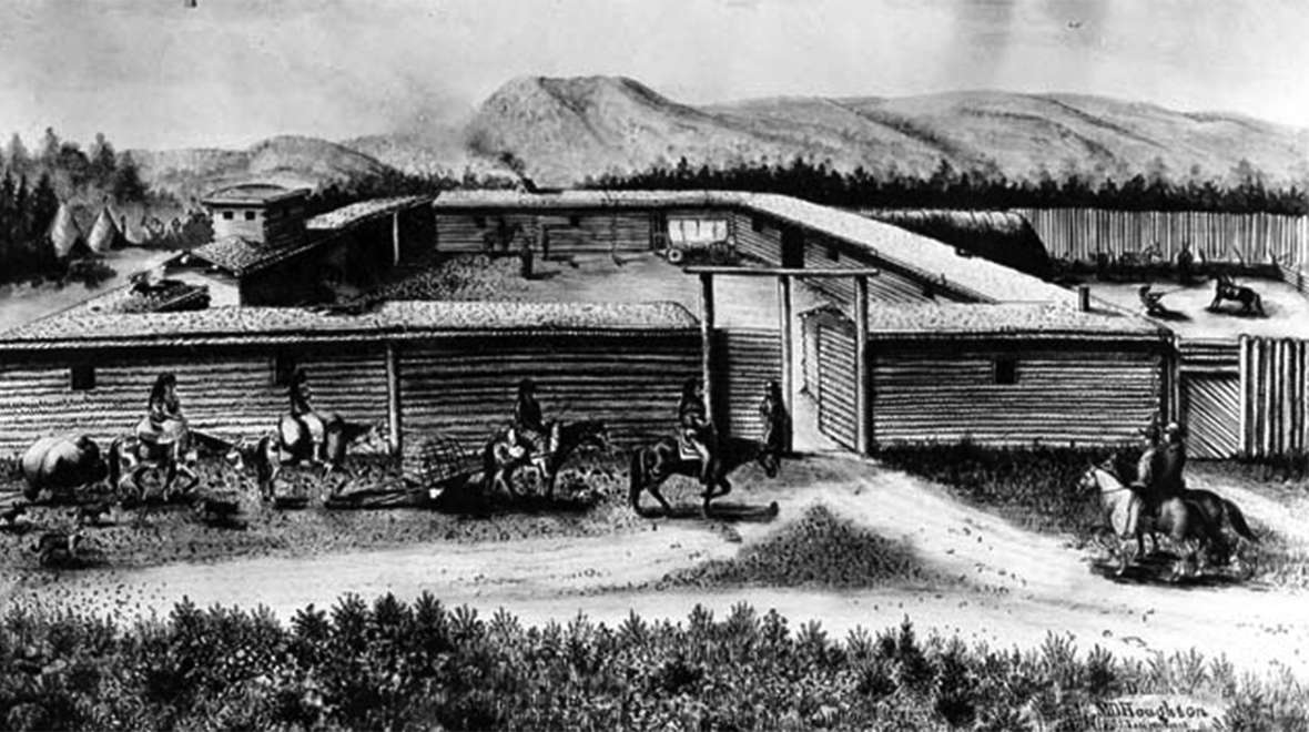
Early in the 1840s, a trickle of Oregon-bound emigrants began following old native and trappers’ routes up the North Platte and Sweetwater rivers to the Continental Divide, down to the Green River, over another divide to the Bear River and on to the Northwest—the Oregon Trail. In 1843, former trappers Jim Bridger and Louis Vasquez established a trading post on the trail, Fort Bridger, on a fork of the Green River in what’s now southwest Wyoming. They prospered trading with the emigrants. Bridger and many other trappers took Shoshone wives and started families near the post.
In 1847, members of the Church of Jesus Christ of Latter-day Saints—the Mormons—fleeing religious persecution in the Midwest, first arrived in the Salt Lake Valley by a route that went directly west from Fort Bridger. Thousands of Mormons began arriving every year. In 1848, gold was discovered in California. Traffic on the trails quintupled in 1849, and doubled again the following year. All these white people traveled with their livestock right through the middle of Shoshone country. Grass was suddenly scarce, and game much harder to find.
In 1851, under pressure from the plains tribes to compensate them for the enormous damage to their lands brought by all the new traffic, the U.S. government negotiated a treaty at Horse Creek , near Fort Laramie, with the Lakota Sioux, Cheyenne, Arapaho and Crow tribes, as well as the tribes of the upper Missouri—Hidatsa, Mandan, Arikara and Assiniboine. The treaty identified separate areas of the northern plains for each of these tribes, where, in exchange for annual payments from the government, they agreed to mostly live and hunt while allowing free passage to whites.
A delegation of about 80 Shoshone men and their families, led by a rising leader named Washakie and accompanied by Bridger, was also present. But for a bureaucratic reason the Shoshones were not invited to sign: Their lands were part of the areas administered by an office of the U.S. Indian Bureau out of Salt Lake City. The Fort Laramie Treaty negotiations, by contrast, were run by the bureau’s St. Louis office. Washakie and the Eastern Shoshone returned home knowing that the new treaty left their interests unprotected.[3]
By this time, meanwhile, the Mormons were hoping to extend their own influence eastward from the Salt Lake Valley. They hoped to compete with the former trappers for the Shoshone trade at Fort Bridger, and in the Green River Valley for the revenue from ferries over the Green River. Around 1855, Bridger and Vasquez lost control of their post. Mormon businessmen took over the lucrative ferries on the Green.
Warfare
White emigration traffic continued on the trails, dividing the great buffalo herds and shrinking them. Conflict increased among tribes trying to live on dwindling resources. The 1851 treaty identified lands for the Crow that stretched west and north from the Powder River into present Montana, over the Bighorn Mountains into the Bighorn Basin and south all the way the Wind River Valley—the same Warm Valley where the Eastern Shoshones also hunted in those years.
Conflict was probably inevitable. Historians are uncertain of the dates, but there appear to have been at least two large battles between Shoshone and Crow warriors in the Wind River Valley in the late 1850s.[4] After the fights, the Crows retreated to the north. Shoshone were more secure on Wind River, buffalo hunting was good and they were far from the constant emigrant traffic on the trails.
In 1857, local tensions between Mormons and non-Mormons combined with national ones to provoke the so-called Utah War, when 2,500 U.S. troops marched west to install a new territorial government in Utah and re-establish federal power. Mormon guerillas raided Army livestock and supply trains, but there was little or no bloodshed. The Eastern Shoshones remained neutral, though according to at least one account Washakie offered 1,200 warriors to the Army. General Albert Sidney Johnston advised the chief to take his warriors hunting instead.[5] In 1858, the U.S. Army acquired Fort Bridger and located a garrison there.
Year after year, the pressures on the tribes increased. In 1859, the government completed a new road, a shortcut west from South Pass across the Green River, the Wyoming Range and Star Valley to Fort Hall in what’s now southeast Idaho. The road was called the Lander Cutoff, for the engineer who supervised its construction. Traffic here, too, was immediately heavy. The road ran right through Shoshone lands, and the tribe, again, was not compensated
Relations between white travelers and the western Shoshone bands, meanwhile, went from bad to worse. Casual murders of Indians by white people traveling the trails were not unknown. In retaliation, young Shoshone men began raiding emigrants and even stagecoaches and stage stations on the trails.
In 1862, most U.S. troops were drawn east from garrisons at Fort Bridger and Fort Laramie to fight in the Civil War, and the trails were left unpatrolled. Eastern Shoshone raiders burned the all the stage stations between the North Platte and Bear rivers, running off all the horses and mules and leaving stagecoaches standing in the road. They killed a stage-station attendant at Split Rock.[6] Raids increased on the trails and stage routes to the west.
A regiment of California volunteers, U.S. troops under Col. Patrick Connor, arrived at Salt Lake City in the late summer of 1862. Tensions increased; raids, hostage-taking and retaliations continued. In January 1863, Connor led about 300 troops in an attack on a western Shoshone village on Bear River, in what’s now southeast Idaho, north of Great Salt Lake. At least 250 and perhaps as many as 400 Shoshones died that day. By the following summer, all the Shoshone and related bands in the region were ready for treaty talks.
The Fort Bridger Treaty of 1863
Early in July 1863, the leaders of a variety of different Shoshone bands including Norkok, Bazil, Washakie and about 10 others, signed a treaty at Fort Bridger with representatives of the Indian Bureau.
The 1863 treaty included these provisions:
- There would be peace between Shoshone people and the people of the United States.
- Travel routes through Shoshone territory would stay open and safe. Ferries and stage stations would also remain unmolested.
- Stagecoaches and telegraph lines would be left alone.
- The route of a transcontinental railroad, now authorized by Congress, which the whites expected to be built in the next few years, would likewise be left alone.
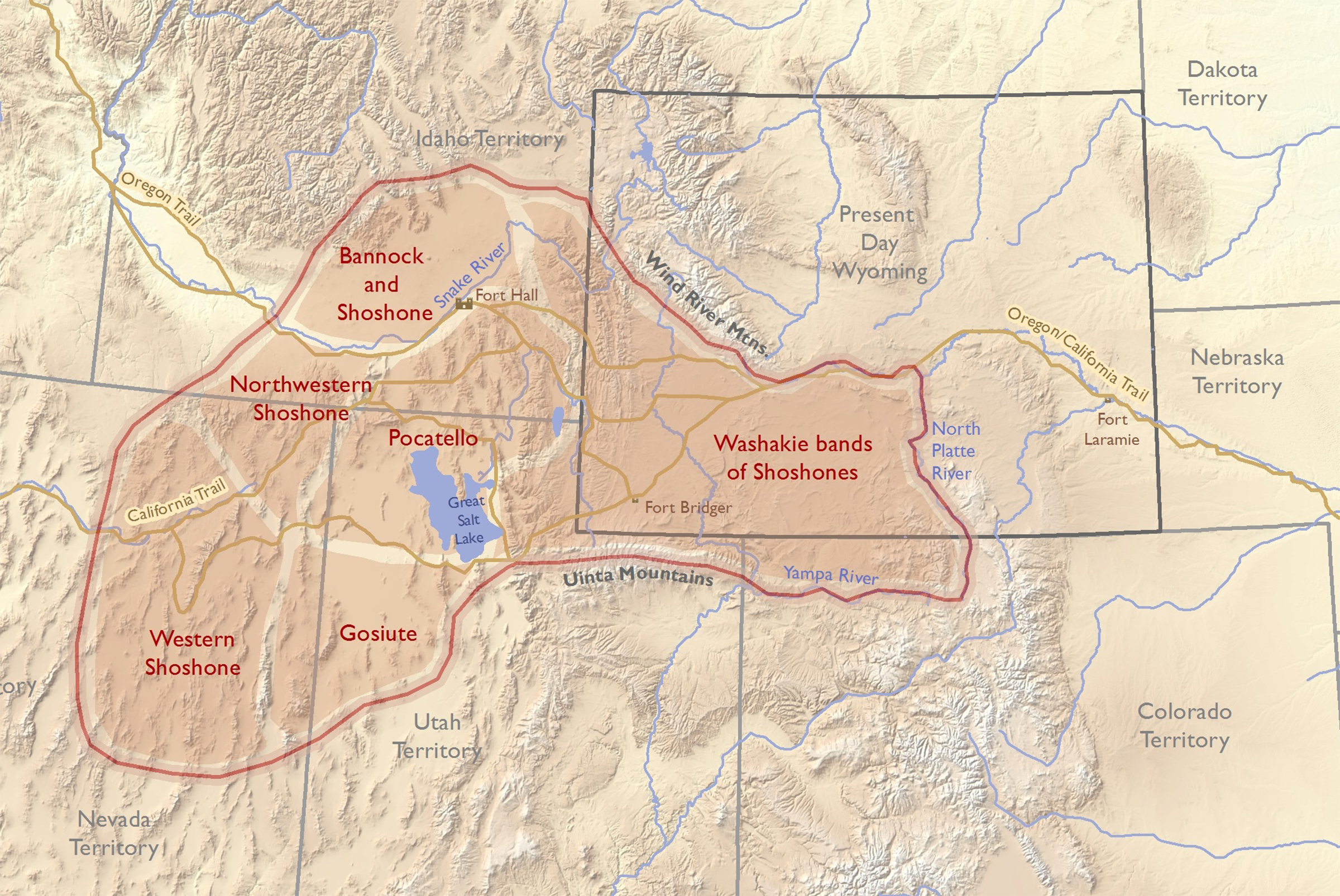
- Shoshone territory would reach from the Snake River on the north to the Wind River Mountains on the northeast, down the Sweetwater to the North Platte on the east, south to the Yampa River of present Colorado and along the crest of the Uinta Mountains, which run east to west along the present Wyoming-Utah border. A western boundary was left undefined, apparently because Shoshone roamed so widely over the Great Basin. Still, modern historians estimate the extent of Eastern Shoshone territory described in the treaty at around 44 million acres—nearly 70,000 square miles.
- Shoshones, in return, would receive in payment an annuity in goods worth $10,000 per year for 20 years, with an up-front bonus of $6,000 worth of goods and presents at the time of the signing. Annuities would be distributed once a year at Fort Bridger.[7]
As summer turned toward fall, the government negotiated and signed four more treaties with western Shoshone groups with similar terms and varying annuity amounts: with Pocatello’s band of western Shoshones at Box Elder, Utah Territory, in July; with western Shoshones and root-gathering groups the whites called Diggers in the Ruby Valley of Nevada Territory on October 1; with Gosiutes in the Tooele Valley of Utah on October 12; and with Bannocks and mixed Shoshone-Bannock bands at Soda Springs in Idaho Territory on October 14.
At Soda Springs, the government negotiated terms under which the Bannock and mixed Shoshone-Bannock bands agreed to share the annuities as well as part of the territory—west of the Wind River Mountains—already promised to the Eastern Shoshones at Fort Bridger.
In any case, the Fort Bridger treaty did not actually protect Shoshone interests as intended. Increased travel on the trails and roads meant increased competition for grass and game. The best buffalo hunting inside the treaty-defined Shoshone territory was near its eastern edge, at the North Platte-Sweetwater confluence around Independence Rock—country that was also becoming heavily used by Arapaho bands and some Lakota hunters.[8]
Movement toward Wind River
As traditional sources of food dwindled in the Great Basin, more Shoshone and Bannock bands moved to the mountains and plains of what is now Wyoming, linking up with Washakie and taking him as leader. This added population and its accompanying political power in turn allowed Washakie to take more risks and make longer hunts for buffalo on the plains to the east and north. One result was more conflicts with other tribes doing the same thing.
|
By this time the only buffalo herds of any size were east of the Continental Divide. Shoshones began concentrating hunting and winter camps there. Conflict followed with Crows still hunting in the Bighorn Basin of what is now northwestern Wyoming, and with Lakota, Cheyenne and Arapaho people also beginning to hunt these lands. In the late 1860s, gold was discovered on the upper Sweetwater near South Pass. “These three human strains,” writes historian Henry Stamm—he means Shoshones, white miners and tribes from the plains to the east—“flowed toward the Wind River after 1863.”
Most of the Eastern Shoshone bands in these years gathered in late August or early September at the head of the Sweetwater for a large buffalo hunt, stopping either there or a short way north on Wind River. After the fall hunt, some made their way back to the Salt Lake and Bear River countries. The rest split into four bands to go into winter camps—one at the Sweetwater-North Platte confluence; one farther east to the Powder River; one that would skirt around Crow camps in the southern Bighorn Mountains also to stay on Powder River tributaries; and Washakie and his band to Wind River.
In spring, most hunted or fished near their winter camps while their horses grew stronger on the new grass. Then all came together for a big spring buffalo hunt on Wind River, and in the summer for the Sun Dance near Fort Bridger. After that they would break up into small family bands until gathering again for the big hunt in the fall.
Fort Bridger had been a regular part of Shoshone nomadic cycles since the 1840s when it was established. After the 1863 treaty, many were generally willing to wait at the fort late in the summer for the annual treaty payments and to postpone the buffalo hunt to Wind River—clear evidence they found the treaty goods valuable. Through the 1860s, Washakie’s bands continued to receive their annuities at Fort Bridger but made their winter camps east of the mountains.
Gold and a railroad
In 1864, war broke out east of the Bighorn Mountains along the Bozeman Trail, a route to the new gold fields of southwestern Montana Territory. Gold seekers were traveling through the heart of the Powder River Basin in direct violation of the terms of the Fort Laramie Treaty of 1851. Arapaho, Cheyenne and Lakota warriors began raiding the freight and emigrant trains. And more people from these tribes, to escape the troubles, began hunting farther west, on Wind River.
The allure of gold drove events in the Wind River country, too. Despite the treaties, whites had been furtively prospecting in the Wind River and Sweetwater drainages since the 1850s. In 1867, they discovered the Carissa Lode on Willow Creek, a Sweetwater tributary near South Pass. The mining camps of South Pass City, Atlantic City and Miner’s Delight sprang up quickly; soon there may have been as many as 3,000 whites in the camps and gulches. Enterprising white farmers began growing vegetables near the Wind River, 40 miles to the north, to feed the people in the camps. Lakota warriors began attacking miners.
At the same time, construction had begun in earnest on the Union Pacific Railroad; passenger service reached Cheyenne in January 1868. With war on Powder River and railroad construction moving fast across the plains, Congress authorized a new peace commission, composed of Army officers and civilians, to negotiate with the plains tribes. The commission met at length with the tribes at Fort Laramie that spring.
In July 1868, commission members continued on to Fort Bridger. They were starting to understand some important factors. Whites in the Sweetwater mining camps and those living near Wind River would be likely to tolerate a Shoshone reservation nearby—as a buffer against the more hostile plains tribes raiding in the mountain valleys. Completion of the railroad would bring even more whites, and thus create more pressure on all Indian lands. And the government land grants to the railroad, which made the financing and thus construction possible in the first place, required that Indian claims to those lands be relinquished before they could be granted to the railroad.
The Fort Bridger Treaty of 1868
On July 3, 1868, leaders of Bannock and Eastern Shoshone bands signed a treaty with the following provisions:
- A reservation would be created in the Wind River Valley “for the absolute and undisturbed use and occupation of the Shoshone Indians herein named …”
- Shoshones would not have to move there until the agency buildings were built.
- Shoshones could hunt off the reservation on “unoccupied lands” of the United States.
- Shoshone children would be educated to promote “civilization” among them.
- Land, seeds and farming tools would be allotted to heads of households.
- Clothing and other goods specified in detail would be distributed to Shoshones every September for 30 years.
- Bannocks would be assigned a separate reservation at a later time.
- Indians would become farmers.[9]
Shoshones come to Wind River
Unlike most reservations, the new one at Wind River had far more white people than native people living on it year-round. One historian estimates as many as 5,000 people lived in the gold-mining camps around South Pass and in the Wind River Valley 40 miles north, where they were beginning to raise crops and livestock to feed the miners.[10]
|
Eleven months after the Fort Bridger treaty was signed, the new Wyoming Territory got its first governor and Indian superintendent. John Campbell wanted the Eastern Shoshones to abandon their nomadic lives and settle on the reservation; at the same time he hoped the tribe could be persuaded to give up the southern third or so of the reservation where so many whites already were living. Campbell also knew that before that would be possible, he would have to meet treaty obligations requiring that the government provide agency buildings, irrigation ditches and farm implements.
Washakie, meanwhile, was reluctant to move too quickly. He insisted the Eastern Shoshone be allowed to continue their old pattern of summers on Wind River and winters at Fort Bridger, where they could continue to receive their annuity goods.
With more and more whites coming to what is now southeast Idaho, meanwhile, Chief Taghee’s Bannock and Pocatello’s Shoshone people continued to hunt buffalo with—and draw their annuities with—the Eastern Shoshone during these years. The Bannock eventually moved to a reservation around Fort Hall, in Idaho, in 1873; Pocatello’s band would join them there in 1876.[11]
The Eastern Shoshone would continue to live in their Warm Valley on Wind River from that time forward. But within a decade, when the U.S. government located the Northern Arapaho on the same reservation, the Shoshone there would find themselves forced to share land they had thought was theirs alone.
Editors’ Note: This and other 2018 and 2019 articles and digital toolkits on the history of tribal people in Wyoming are possible with support from the Wyoming Cultural Trust Fund, the Wyoming Council for the Humanities and several Wyoming school districts, including districts headquartered in Fort Washakie, Arapahoe, Shoshoni, Lander, Powell, Laramie, Douglas and Afton, Wyoming. WyoHistory.org extends its thanks to all.
Resources
Sources
- Flynn, Janet. Tribal Government: Wind River Reservation. With an introduction by Scott J. Ratliff. Lander, Wyo.: Mortimore Publishing, revised edition, 1998.
- Fowler, Loretta.Arapaho Politics, 1851-1978: Symbols in Crises of Authority. Lincoln, Neb.: University of Nebraska Press, 1982, 48.
- Stamm, Henry E. IV. People of the Wind River: the Eastern Shoshones, 1825-1900. Norman, Okla.: University of Oklahoma Press, 1999. A useful, reliable source on the Eastern Shoshones of the 19th century, with emphasis too on their relations with their white and Arapaho neighbors.
- “Treaty with the Eastern Band Shoshoni and Bannock, 1868.” Indian Affairs: Laws and Treaties. Vol. II, Treaties, pp. 1020-1024. Kappler, Charles J., editor and compiler. Washington: Government Printing Office, 1904. Accessed April 189,2019, at https://dc.library.okstate.edu/digital/collection/kapplers/id/26861. Text of the 1868 Fort Bridger Treaty with the Eastern Shoshone and Bannock tribes.
- “Treaty with the Eastern Shoshoni, 1863.” Indian Affairs: Laws and Treaties. Vol. II, Treaties, pp. 846-848. Kappler, Charles J., editor and compiler. Washington: Government Printing Office, 1904. Accessed March 25, 2021 at https://dc.library.okstate.edu/digital/collection/kapplers/id/26689. Text of the 1863 Fort Bridger Treaty with the Eastern Shoshone tribe.
- “Treaty with the Shoshonee and Bannacks, July 3, 1868.” Jackson Hole Historical Society and Museum’s website. Accessed Dec. 8, 2017, at http://jacksonholehistory.org/wp-content/uploads/1868-treaty.pdf .
- Trenholm, Virginia Cole and Maurine Carley. The Shoshonis: Sentinels of the Rockies. Norman, Okla.: University of Oklahoma Press, 1964, 100-222.
For further reading
- Separate lands for separate tribes: The Horse Creek Treaty of 1851
- Peace, War, Land and a Funeral: The Fort Laramie Treaty of 1868
- South Pass Gold Rush
- John Campbell and the Invention of Wyoming
Illustrations
- The two maps were prepared the Wyoming Geographic Information Science Center at the University of Wyoming. Special thanks to Margo Berendsen, cartographer.
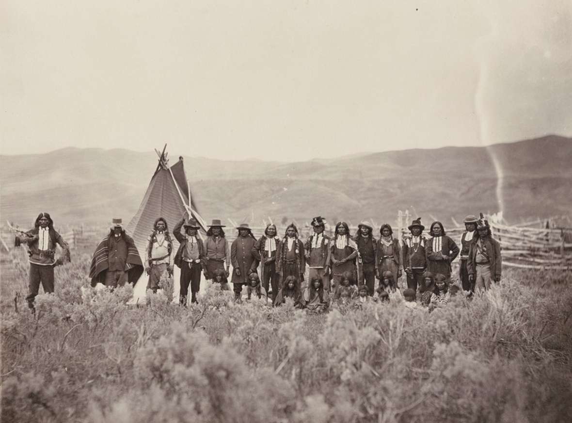
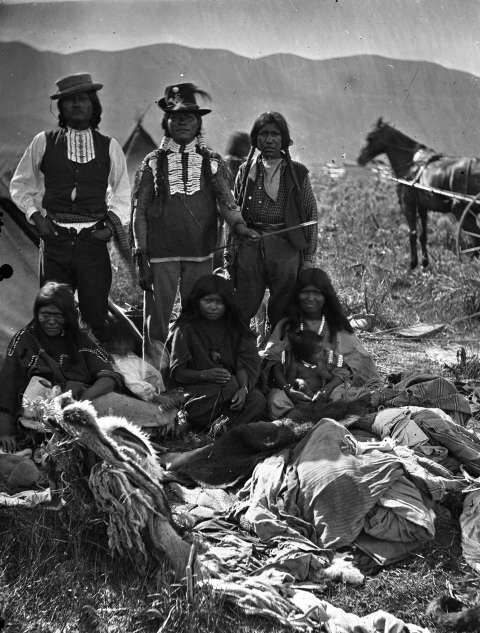
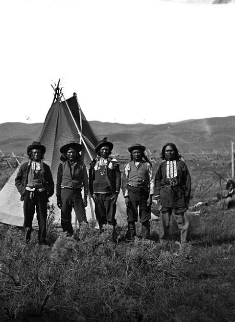
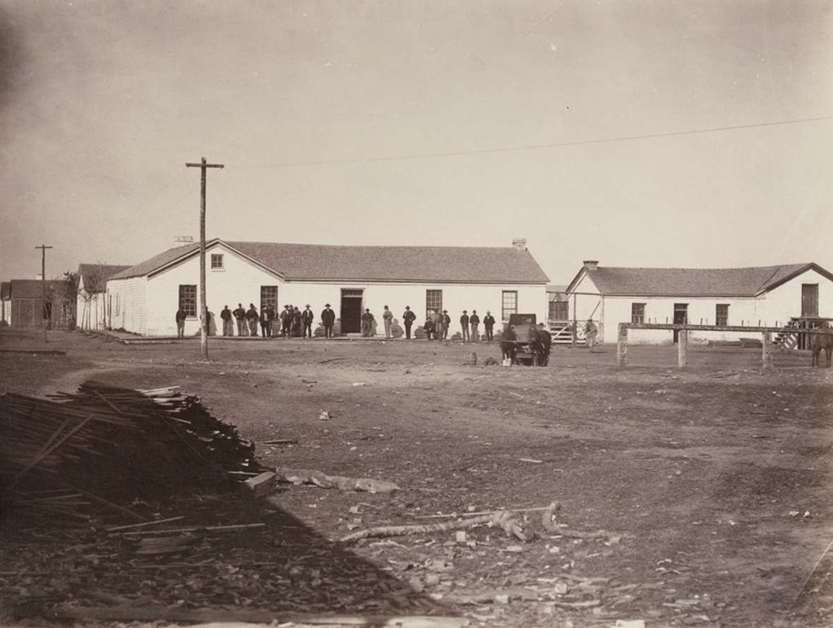
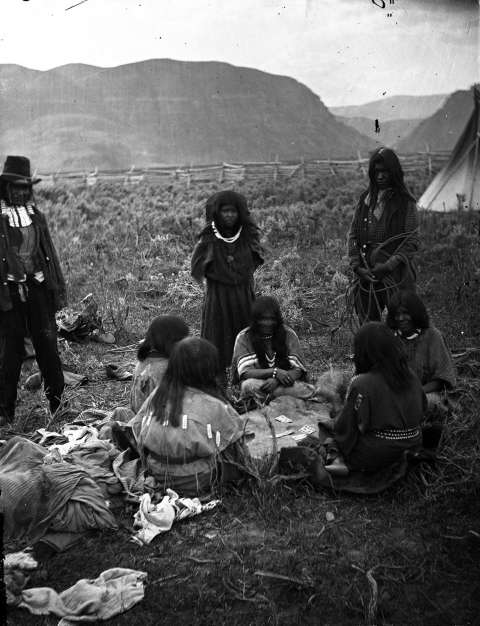
- The A.J. Russell photos of white buildings at Fort Bridger and of Shoshone men standing in a long line with women seated in front of them are from the collections of the Beinecke Library at Yale University. Used with thanks.
- The other Russell photos are from the digital collections at the Oakland Museum of California . Used with thanks.
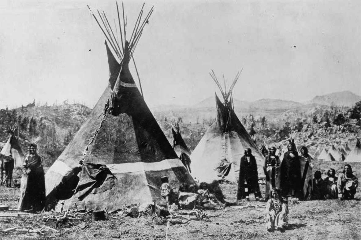
- The William Henry Jackson photo of the Shoshone village near South Pass, 1870, is from the Smithsonian; this scan is from Wikipedia. Used with thanks.
[1] Flynn, Janet. Tribal Government: Wind River Reservation, 36.
[2] Stamm, People of Wind River12-16.
[3] Trenholm and Carley, The Shoshonis, Sentinels of the Rockies, 121.
[4] Trenholm, 168-174.
[5] Trenholm, 157, 168.
[6] Trenholm, 190-192.
[7] “Treaty with the Eastern Shoshoni, 1863.”Indian Affairs: Laws and Treaties. Vol. II, Treaties, pp. 846-848. Kappler, ed.
[8] Trenholm, 199-206. Stamm, 27-40, “their economic stronghold,” 27; “Treaty with the Eastern Shoshoni, 1863.”Indian Affairs: Laws and Treaties. Vol. II, Treaties, pp. 848-849. Kappler, editor.
Stamm, 42-51; “Treaty with the Shoshonee and Bannacks, July 3, 1868.” Jackson Hole Historical Society and Museum’s website. Accessed Dec. 8, 2017 at http://jacksonholehistory.org/wp-content/uploads/1868-treaty.pdf .
[10] Loretta Fowler, Arapaho Politics, 48.
[11] Stamm, 59-61, 79-85.