The Coal Business in Wyoming
“Among the materials that are dug because they are useful,” the ancient Greek scientist Theophrastus wrote around 300 B.C., “those known as coals are made of earth, and once set on fire, they burn like charcoal…used by those who work in metals.” Coal has long been valued as a heating element and energy source. Today, it is the most plentiful fuel in the fossil family, representing a major source of electrical generation to the world.
In the Americas, the Aztecs from the 14th through 16th centuries were the first documented people to use coal as a heating fuel. While records for Wyoming do not indicate if American Indians used coal, early trappers were known to have found it on the ground and used it for fuel.
The first record of a coal deposit in Wyoming was in 1843 by the second Frémont Expedition. Lt. John C. Frémont, guided by Kit Carson, set out to explore routes to Oregon with the intent to gather, publish and promote new settlement in the West. In August 1843, a few days after crossing the Green River in what’s now western Wyoming, Frémont noted coal was displayed “in rabbit burrows in a kind of gap” in hills through which the travelers passed before camping late one afternoon.
Sixty years later, the area of Frémont’s discovery became the site of the coal camp of Cumberland, south of Kemmerer in what is now Lincoln County, Wyoming. Many coal camps in the Rocky Mountain West consisted of company towns like Cumberland, in which everything – the general store, workers’ houses, schools and public halls—was all owned by the coal company.
The Raynolds Expedition in 1859 recorded the second known discovery of coal in the state in the Powder River Basin – the location of the most prolific coal fields in the nation today. Geologist Ferdinand V. Hayden, later director of the U.S. Geological Survey, was with Raynolds on the 1859 expedition and came across what he said were “true lignite beds” covering the region from Platte County to Pumpkin Buttes in what is now Campbell County. Lignite is a low-grade coal.
Commercial Mining
Commercial mining for coal in Wyoming began with the arrival of the Union Pacific Railroad in 1867. Coal was used to fuel steam engines to power locomotives. It was the primary source of fuel for trains until diesel engines replaced the locomotives in the mid-20th century. The U.P.’s route across what soon became Wyoming Territory depended on two main factors, topography and plentiful coal. The route connected the major mines of Carbon, Rock Springs and Almy, Wyoming, near Evanston.
The first mines were owned by the Wyoming Coal and Mining Company, which leased the land from the railroad. The company mined the coal and sold it to the railroad for a profit. In 1874, the government terminated the agreement between the two companies. Consequently, the Union Pacific Coal Company was formed as the Union Pacific Coal Department by the Union Pacific Railroad, with the railroad effectively taking over the mines. U.P. Coal Company then had a monopoly on coal production in the territory and used the coal primarily for its railroad operations
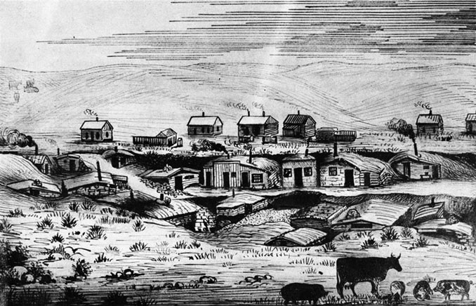
Carbon, on the UP line southwest of Medicine Bow, was founded by Thomas Wardell in 1868 and incorporated in 1890. Seven mines were worked in Carbon and the town supported a population of about 3,000 people.
In 1899 the railroad was relocated to Hanna, just northwest of Carbon, to avoid climbing a steep grade. The Hanna mine then became the main supplier of coal for train locomotives. The mines and the town of Carbon were finally abandoned in 1902 by the U.P. Coal Company. All that remains of the town is the cemetery, dugouts that served as houses on the hillside, and a few of the sandstone walls and foundations from the buildings that made up this once flourishing coal town.
The Carbon cemetery, which is listed on the National Register of Historic Places, located just north of the town, includes the graves of many members of the Carbon community. It also contains the graves of some of the miners killed in an explosion in one of the Hanna mine on June 30, 1903, which took the lives of 169 men. A pair of explosions in 1908 killed 59 more. The accidents decimated the town’s male population and left hundreds of orphaned children and widows.
“The Carbon cemetery is a place that preserves the lives of these people in the landscape where they lived and worked,” says Nancy Anderson, curator of the Hanna Basin Museum. The museum protects the records and artifacts of Carbon and Hanna coal miners and their families from that era, including the records of Hanna’s mine disasters.
Coal mining at Rock Springs, 140 miles west of Carbon, also began in the late 1860s to supply coal to the U.P. During the next century, more than 100 million tons of coal came from Rock Springs mines. The last mine closed in 1963, when Rock Springs had turned to other extractive industries such as oil and natural gas.
Mine Safety
Coal mining in the early days was a hard, dangerous job. Thousands of Wyoming miners lost their lives from explosions and fires. More than 300 miners died in disasters between 1886 and 1924. Black lung disease, from long exposure to coal dust, also plagued miners. Most of these dangers were connected with miners working in cramped mine shafts and larger underground rooms that could quickly fill with deadly gas.
Since the early mining disasters Wyoming has made significant strides to improve mine safety in the state. In 1886 the Wyoming Territorial Legislature, convening by chance just days after another major disaster at Almy, passed new mine safety laws. The new office of the State Mine Inspector was charged with inspecting every coal mine in the state once every three months.
In the early 1900s, prompted by so many accidents in the previous decades, the State Geologist was granted the authority to examine or inquire into any mine or mill in regard to worker safety; any accident was to be investigated. Other safety measures included a law establishing a uniform code of bell warning signals for use in the mines.
Union representatives took the initiative and spoke up publicly to protest mining disasters, insisting on more compensation for dependents of miners killed. Labor unions attracted new members by promising to seek greater safety. Safety features such as underground ventilation systems and rock dusting—a process using crushed limestone to dilute the explosive nature of coal dust—have provided miners with better protection.
Today, mining operations are much safer, especially in Wyoming where nearly all the coal now mined—at 17 out of 18 coal mines currently in production—comes from strip mines on the earth’s surface. Since 1978, the federal Mine Safety and Health Administration (MSHA) has overseen safety and worker protection at mines throughout the United States. In 2012, MSHA reported 19 coal miners in the nation had died in on-the-job accidents, the second lowest number ever recorded.
But even with increased safety measures, surface and underground mining both remain dangerous. Surface mining requires constant safety checks of log books, powder magazines used for blasting and the major equipment used to load coal and haul it away.
Underground mining —far more dangerous—requires constant checks on air quality, roof integrity and fire danger. Rescue of miners trapped underground can be extremely difficult. Explosions are also a risk; twenty-nine miners were killed in 2010 in an explosion at West Virginia’s underground Upper Big Branch Mine, owned by Massey Energy.
Strikes
After 1874, as we have seen, the Union Pacific held a monopoly on coal production in Wyoming. Late that year, the U.S. secretary of the Interior noted that U.P. was able to sell Wyoming coal, delivered in Omaha, Nebr. for the modern equivalent of $9 per ton, while charging other coal companies $10 per ton just to ship their freight.
U.P. Coal Company officials also held a tight rein on worker pay. In 1875, company executives cut the work rate paid to miners by one-fifth, but kept charging the same coal prices to its buyers. When the miners went on strike, company officials replaced them with Chinese laborers who worked for less. This led to a long series of strikes, and eventually to murder.
In 1885, the Rock Springs Massacre made national headlines. The miners’ resentment of the U.P. Coal Company and its pay cuts, combined with rumors that Colorado miners were to receive pay raises, resulted in a major uprising. Members of a union called the Knights of Labor burned the homes of 74 Chinese families, and 28 people were killed. The Chinese fled toward Green River and U.P. trainmen rescued them as they fled along the tracks. Federal troops were called in to restore order and eventually the Chinese returned to work.
Coal Uses
During the Industrial Revolution in the 18th and 19th centuries, coal became the dominant worldwide energy source. In Wyoming, as in other places with growing industry, coal was cheap and abundant. It was much easier to mine coal than to cut wood for fuel. Hotter coal fires brought major changes in the metal industries. Demand grew for the products of the new technologies fueled by coal. Converting coal into clean natural gas was also first considered at this time; cities such as Boston used large ovens to turn coal into gas that fueled streetlights and lamps in homes.
In the second half of the 19th century, more uses for coal were discovered. Civil War weapons factories converted to coal. By 1875, coke, a hotter fuel refined from coal, replaced charcoal as the primary fuel for iron blast furnaces used to make steel. Smith’s Fork in what is now Lincoln County, a long-time trading post for trappers and Indians, changed its name to Cokeville because of large deposits of coke-suitable coal nearby.
A 1907 report by the Wyoming State Geological Survey (WSGS) noted, “coal was the principal mineral product of Wyoming, constantly increasing in volume” as the railroad’s demand for the product grew. According to the report, the quality ranged from high-quality coal from the famous Kemmerer and Rock Springs coal seams, to low-grade lignites found near a dozen towns in Wyoming.
Growth in coal production spiked again during World War II, when national demand soared for Wyoming’s coal and other natural resources.
In the 1960s, Wyoming’s first coal-fired electric-power generation plants were built, establishing a reliable local market for coal. In the 1970s, demand boomed for low-sulfur Powder River Basin coal after new amendments to the Clean Air Act began regulating sulfur emissions. Most of the coal from the Powder River Basin is shipped by rail to power plants in 34 states.
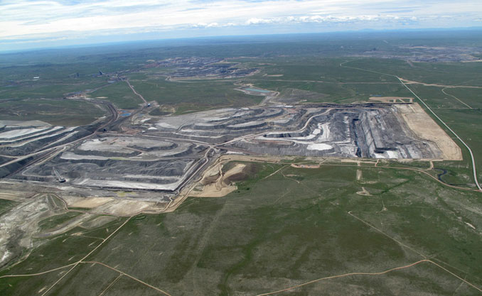
Wyoming’s strip mines increased enormously in size in the 1970s. Today they represent the largest scale of coal mining anywhere in the world. Wyoming is home to nine of the nation’s 10 largest coal mines, and coal in Wyoming is mined at a rate of 12 tons per second. Fifty to 70 coal trains per day carry coal out of the Powder River Basin. The trains are generally 110 to 140 cars long, carry 15,000 to 20,000 tons of coal each, and stretch more than 1.5 miles along the tracks.
Wyoming produces around 400 million tons per year—nearly 40 percent of the nation’s coal.
WSGS Role
Since Territorial days the Wyoming State Geological Survey (WSGS) and the Wyoming State Geologist have played major roles in researching and tracking Wyoming’s coal resources. In 1976, a new building and headquarters for the agency was built on the University of Wyoming campus in Laramie, where the work of the WSGS became more specialized.
Wyoming geologists formed a special coal section and coordinated their efforts with the U.S. Geological Survey to evaluate the northern coal lands of the Powder River Basin. The state agency also reported on the strippable coal reserves of the Hanna Coal Field for the U.S. Bureau of Mines, and performed a variety of other studies related to the state’s increasingly important coal reserves.
The WSGS maintains a wide variety of records and maps on this natural resource and its economic importance to the state, the nation, and increasingly to the world. The agency researches and produces a variety of written materials on Wyoming’s coal resources, from publications to maps, website content to summary reports. It also tracks and forecasts industry and economic trends for decision makers for a “material” that has long been considered more than useful since its early discovery. Twenty three hundred years after he first noted that “coals made of earth” would burn, Theophrastus would find that not only do they still burn—they provide electricity to the world.
[Editor’s note: Chamois Andersen is currently head of communications and outreach for the Wyoming State Geological Survey.]
Resources
Primary sources
- Beeler, H.C. Wyoming Mines 1907. Geological Survey of Wyoming. Laramie, Wyo. 1908.
- Coal and Oil of Wyoming. Wyoming Board of Immigration Bulletin 3. Cheyenne, 1911.
- Frémont, John Charles, John Torrey, James Hall, and Charles Preuss. Report of the exploring expedition to the Rocky Mountains in the year 1842, and to Oregon and north California in the years 1843-'44. Washington: Gales and Seaton, printers, 1845, p. 131. Accessed Oct. 5, 2013 at http://books.google.com/books/about/Report_of_the_Exploring_Expedition_to_th.html?id=SMwQAAAAIAAJ
Secondary sources
- Bryans, W. A History of the Geological Survey of Wyoming. Geological Survey of Wyoming Bulletin 65. Laramie, Wyo. 1986.
- “Coal Camp Photos.” Wyoming Tales and Trails, accessed Oct. 4, 2013 at
- http://www.wyomingtalesandtrails.com/coal.html.
- U.S. Energy Information Administration, “Wyoming State Profile and Energy Estimates,” accessed Oct. 4, 2013 at http://www.eia.gov/state/?sid=wy.
- U.S. Department of Labor Mine Safety and Health Administration (MSHA), accessed Oct. 4, 2013 at http://www.msha.gov/.
Illustrations
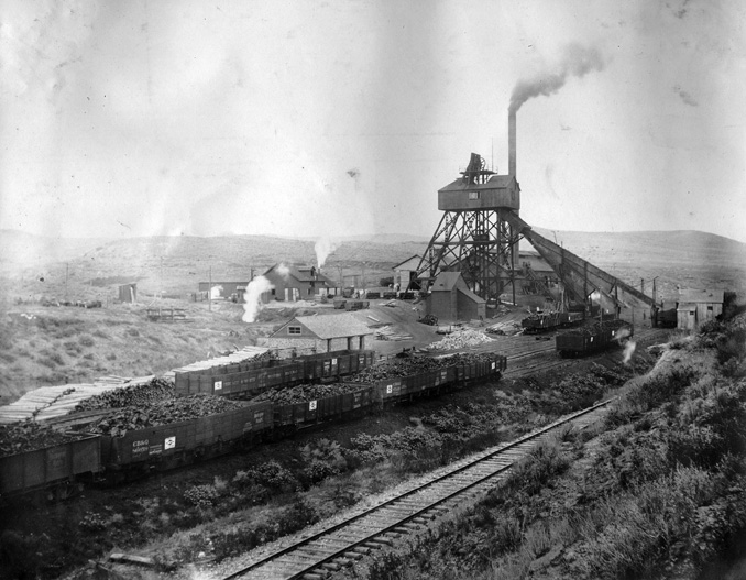
- The 1909 photo of the Dietz mine and tipple is from the Juroshek collection, Wyoming Room, Sheridan County Fulmer Public Library. Used with permission and thanks.
- The drawing of Carbon ca. 1870 is from the Carbon County, Wyo. website. Used with thanks.
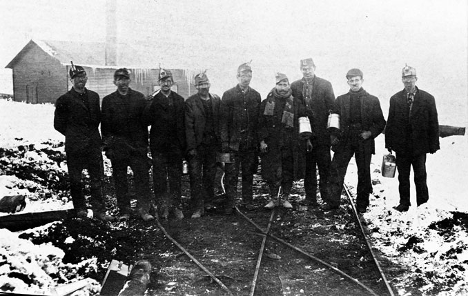
- The 1909 photo of the miners at the Indian Mine near Hudson, Wyo. is from the Riverton Museum. Used with permission and thanks.
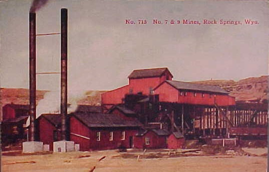
- The undated photo of U.P. Coal mines 7 and 9 at Rock Springs is from Wyoming Tales and Trails. Used with thanks.
- The 2012 photo of the Black Thunder Mine, and the four other photos of Powder River Basin strip mines in the photo gallery are from Ecoflight. Used with thanks.