Big Horn County, Wyoming
Big Horn County, on the west side of the Bighorn Mountains, takes up most of the northeastern portion of the much larger Bighorn Basin, which stretches north from the Owl Creek Mountains to the Pryor Mountains in southern Montana. On its east and west sides, the basin is rimmed by the Bighorn Mountains and the Absaroka Range, respectively.
The Bighorn River flows from south to north through the county, with the Greybull and Shoshone Rivers flowing into it from the west. When displayed on a map, this suggests a wiggly tic-tac-toe design with one vertical bar missing. Beginning in the late 1800s, canals tapping into these three main waterways furnished water for irrigation.
Approximately 10,000 years ago, mammoth hunters probably occupied the area. Crow ceramics suggest the presence of that tribe in perhaps the mid-1700s. The Medicine Wheel on Medicine Mountain overlooking the Bighorn Basin is clear evidence of the work of native cultures, most probably Indians sometime in the 1770s.
In 1807, George Drouillard, who had first come west three years earlier with the Lewis and Clark expedition, may have been the first beaver trapper to enter the northern Bighorn Basin. He encountered a Crow village near present-day Cody, Wyo.
Other expeditions followed, including members of the Missouri Fur Company in 1823-24 and a party headed by General William Ashley in 1825. Ashley chose this roundabout route back to St. Louis from a rendezvous on Henry's Fork of the Green River. Blackfeet attacked Ashley’s group as they followed the Bighorn River north, downstream, through the basin.
Early settlement
Cattlemen moved into the area starting in the 1870s. Henry Clay Lovell owned one of the largest herds--approximately 25,000 head--with his range covering nearly the whole length of the basin from southern Montana to present Thermopolis, Wyo. Otto Franc von Lichtenstein, who soon shortened his name to "Otto Franc," established his Pitchfork Ranch on the Greybull River in 1879 with about 1,200 head of cattle. His ranch was in part of what is currently Park County and also stretched into the modern boundaries of Big Horn County. The present-day town of Otto in Big Horn County was named for him.
Settlers also began filtering into the basin in the 1870s, including, as time went on, men with their wives and children. Many of the earliest settlers ran sheep as well as cattle, and an inevitable clash arose between those who regarded the open range as their property and those who wanted to fence and farm the land. In 1895, when Mormon settlers arrived from Utah by the hundreds and began digging canals to irrigate their crops, the era of the small farmer had clearly begun.
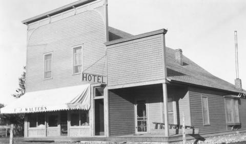
Hyattville, one of the first settlements in what’s now Big Horn County, predated the arrival of the Mormons by perhaps a decade. First called Paintrock for the creek next to it, the town was renamed for Samuel W. Hyatt, an early settler who established a store there in 1886. Hyatt was the town's first postmaster, and by all reports was a fine citizen.
Another early town, Bonanza, southwest of Hyattville near the confluence of Paintrock Creek and the Nowood River, was likewise started in the 1880s and became the focus of activity surrounding the discovery of a small oil spring. Bonanza was also the location of the first newspaper in the Bighorn Basin. The premier edition of the Big Horn Rustler, edited by Joseph DeBarthe, was published June 1, 1889. Like many other early newspapers, it exaggerated the virtues of the new settlement, telling of unlimited coal deposits and the healing powers of "Bonanza Oil." Also like its contemporaries, DeBarthe’s paper included very specific news items about specific people—who, for example, was cutting logs for a house. A copy of this first edition of the Rustler has survived and is currently housed at the Fremont County Library in Lander, Wyo.
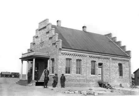
In March 1890, less than a year after the Rustler began publication, the Wyoming Legislature approved creation of Big Horn County out of parts of what then were Sheridan, Johnson and Fremont counties. The new county was not officially organized until Jan. 4, 1897, however, with the election of commissioners and the beginning of county government.
The original Big Horn County covered approximately 8 million acres in the Bighorn Basin—roughly 12,500 square miles, or about an eighth of the entire state. It stretched west from the crest of the Bighorn Mountains to the Continental Divide, and from Owl Creek on the south, just north of the Owl Creek Mountains and Thermopolis, it stretched to the Montana line. The northwest portion included part of Yellowstone Park.
Basin City finally won voters’ approval as the county seat after a heated campaign, reflected in newspaper editorials in the Otto Courier, edited by Lou Blakesley, and the Basin City Herald, edited by Joseph Magill. Both newspapers are long gone, though the Basin Republican-Rustler, descendant of the earlier Rustler, continues to thrive, as do the more recent Lovell Chronicle and Greybull Standard.
As population in the basin grew, more counties were proposed, and eventually the original Big Horn County was divided into Park County on the west, organized in 1911, and Hot Springs and Washakie counties to the south, both organized in 1913. Thus, present-day Big Horn County is approximately 1,990,400 acres, less than a fourth of its original size.
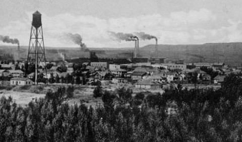
Towns, too, were founded and began to grow. Lovell, in the northern part of the county near the confluence of the Shoshone and Big Horn rivers, began with a post office in 1888 and became a town around 1900. Also in the north, farther west along the Shoshone, were Cowley, incorporated 1907, and Byron, incorporated 1912. Deaver, approximately 15 miles north of Byron, was incorporated in 1919. Greybull, about 32 miles south of Lovell, at the junction of the Greybull and Bighorn rivers, was incorporated in 1909.
Seventeen miles west of Greybull, Emblem, its name changed from Germania in 1918, established its post office in 1899. Shell, on Shell Creek in the foothills of the western slope of the Bighorn Mountains, was platted April 28, 1900. Shell was named for the many shells and fossils in its vicinity. Manderson, on the Bighorn River near the southern border of Big Horn County, was incorporated in 1921.
End of mob rule
Prior to the organization of Big Horn County in 1897, there was little law enforcement. To file on land and conduct other legal business, settlers who lived east of the Bighorn River had to travel 100 miles or more east through the Bighorn Mountains to get to the Johnson County seat at Buffalo. Those who lived west of the river were in Fremont County, and had to travel south even farther, all the way to Lander.
Later, with an established government in Big Horn County, county business could be pursued and crimes prosecuted in Basin City. This became especially important after the notorious Spring Creek Raid of April 2, 1909, south of Ten Sleep in what’s now Washakie County, but then was still part of Big Horn County. Three sheepmen were murdered, two of them burned inside their wagon and the third shot dead. Two more men were kidnapped, and dozens of sheep were also killed.
In Basin City, the ensuing trials and their outcome became a pivot-point in the history of the whole region. Two of the seven perpetrators turned state's evidence, and after a sensational trial in November 1909, the other five were convicted. The event marked the end of Wyoming's 30-year era of lynchings and thwarted prosecutions.
Worland attorney John Davis, who has written three books on those troubles, notes that jury demographics were a crucial factor in the successful convictions. Unlike previous attempted prosecutions in sheep-cattle conflicts, the 12-man jury was comprised of probably four Mormon farmers who almost certainly had no special prejudices either for or against the sheep or cattle interests. Davis notes they would have been likely to sympathize with victims of mob violence, because of their own people’s persecution by mobs across the Midwest, three generations before.
Mormon settlement
By the time of the Spring Creek Raid, Mormons had been in what’s now Big Horn County nearly 15 years. In the spring of 1895, a hundred families moved to the land along the Greybull River to live and to dig a canal, and this settlement became the town of Burlington. By 1897 there were 250 families in Burlington, west and north of Basin City. Structures in the town included a combined meeting house and school, a water-powered gristmill and three sawmills.
Three years later, in February 1900, a party of Mormons traveled from Salt Lake City to investigate water development and farming near the Shoshone River in the northern Bighorn Basin. An existing water project near the growing settlement of Lovell, begun by the Cincinnati Canal Company in 1896, had been relinquished to the State of Wyoming two years later.
Charles Kingston, working on behalf of the Mormon Church, applied for transfer of the Cincinnati Canal water right and lands, and the name was changed to the Sidon Canal.
By mid-July 1900, more than 400 settlers had arrived, pitched tents and planted gardens. Soon after, they began digging the canal. The small community of Byron followed in October. At that time, 40 houses were being built there.
In 1899 Abraham Owen Woodruff had been appointed by church authorities in Salt Lake City as supervisor of the Mormon colonies. At the end of the canal-building and growing season of 1900, the Sidon Canal settlers needed cash, and Woodruff negotiated a grading contract on their behalf for 27 miles of the Burlington Railroad branch from Toluca, Mont., through Frannie Junction, Wyo., to Cody.
The Burlington Railroad
The earliest railroad connection affecting the Bighorn Basin had been established six years before when the Burlington ran its line to Billings, Mont., in 1894. This made it possible for residents of the northern basin to ship their merchandise—mostly cattle at that time—by a shorter, more easily traveled route than the one through mountain passes and over rocky land.
When the railroad line was extended into northern Wyoming with the Toluca-Cody branch in 1901, a trip to Billings was no longer necessary. However, this was not the major line needed to open up the main part of the basin to commerce by rail.
Work did not begin until Oct. 3, 1905, on a line that extended south from Frannie Junction along the Bighorn River through all of present-day Big Horn County. This line halted at Kirby, Wyo., just a few miles north of Thermopolis. A freight terminal was placed eight miles north of the town of Basin, and this location became the site of the town of Greybull.
Sugar beets
Now farmers and ranchers could easily ship their goods to market. This was especially important for sugar beet growers, who previously hauled their crops to Cody or to Frannie Junction or, before the Toluca line, all the way to Billings to the Great Western Sugar Company.
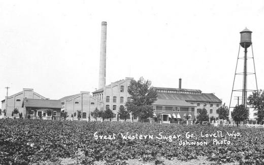
The first carload of sugar beets was shipped out of Powell, Wyo., then still in Big Horn County, on Oct. 14, 1909. The Great Western Sugar Company built a processing plant in Lovell in 1916, ensuring a solid market for locally grown sugar beets. In Calendar of Change, Big Horn Basin historian Paul Frison notes a steady increase in freight, mostly farm products, including some from other states, and explains that the number of carloads peaked between 1930 and 1940.
Oil
The Bonanza oil reserves, despite the early excitement they generated, had at first proven shallow and not worth extensive exploration. Later, starting in 1951, the Bonanza Field produced 603,686 barrels, and at the end of 1956 there were 40 wells, which produced more than 5,000,000 barrels that year alone.
Near Byron a small oil seep was known to exist, and in 1905 natural gas was discovered escaping from a fence hole on the farm of Edward E. Jones. The commercial possibilities of natural gas were not yet known, which explains why this gas was ignited and left to burn.
Jones became interested in oil exploration, however, and drilling began in 1906 near the natural gas site. Continued exploration for the next five to six years turned up large amounts of natural gas and a number of shallow oil wells that refilled when pumped dry. This indicated the presence of a larger reservoir in the area and spurred further exploration.
From approximately 1907 on, oil fields were discovered and wells were drilled at the Torchlight Dome Oil Field near Greybull; at Grass Creek northwest of Thermopolis; in Elk Basin in present-day Park County; and in the Oregon Basin southeast of Cody.
Refineries followed, with pipelines built to Cowley, Greybull, Lovell and, in Hot Springs County, Thermopolis. Along with the railroad lines through these communities, the thriving oil industry boosted the economy of the whole area.
Nearly a decade after the railroad line terminated at Kirby, Wyo., on June 14, 1914, a railroad connection was completed all the way through the Bighorn Basin via the Wind River Canyon, finally establishing service between Billings and Denver. The first highway through the south end of the basin opened for traffic in early 1924, also via the Wind River Canyon. Thus, easier access to the Bighorn Basin, so long isolated by its mountainous borders, was finally ensured.
Throughout the first half of the 20th century, agriculture remained important in the Bighorn Basin, exceeding even oil and gas in gross revenues and generating more than $30 million in 1950. Sheep and cattle accounted for more than 50 percent of this amount. Crops, including sugar beets and dry beans, were also an important part of the balance.
In 1950, oil and gas produced more than $13 million for the basin as a whole.
Other important resources include coal, sulfur, shale, and bentonite. Bentonite is a fine clay used primarily in oil drilling to flush cuttings out of the hole as the well is being drilled, though it has many other uses as well. From 1951 to 1956, at least 466,000 tons of bentonite were processed in the Magnet Cove Barium Corporation's mill near Greybull. Magnet Cove, now M-I Swaco, is still operating near Greybull.
Lovell became an important site for shale mining and processing, and bentonite is now an important component of the Lovell area economy. This includes the mining and/or processing activities of Bentonite Performance Minerals; Wyo-Ben, Inc.; Colloid Environmental Technology; and GK Construction. In addition, the sugar beet processing plant, now known as the Western Sugar Cooperative, is still operating today in Lovell.
At the north end of the basin, the Yellowtail Dam in Montana was completed in 1967. This project flooded the Bighorn Canyon, providing power, bringing more water for irrigation and creating opportunities for boating and fishing. The Bighorn Canyon National Recreation Area was designated in 1968 and now draws more than 200,000 visitors annually.
World-class trout fishing on the Bighorn River and the scenic beauty of much of Big Horn County continue to attract tourists. These revenues, along with manufacturing and various associated wholesale and retail activities, help support and diversify the county's economy.
Resources
Primary Sources
- Basin Republican, Nov. 5, 1909. Accessed Oct. 12, 2012 via the Wyoming Newspaper Project at www.wyomingnewspapers.org.
Secondary Sources
- Davis, John W. Goodbye, Judge Lynch: The End of a Lawless Era in Wyoming's Big Horn Basin. Norman: University of Oklahoma Press, 2005, 128-129; 168-170.
- Donahue, James, ed., Wyoming Blue Book: Guide to the County Archives of Wyoming, Vol. V, Part I. Centennial Edition. Cheyenne, Wyo.: Wyoming State Archives, Department of Commerce, 1991, 106-109.
- Frison, Paul. Calendar of Change. Worland, Wyo.: Serlkay, Inc., 1975, 195.
- Trenholm, Virginia Cole, ed., Wyoming Blue Book, Vol. III. First Edition. Cheyenne, Wyo.: Wyoming State Archives and Historical Department, 1974, 352.
- Wasden, David J. From Beaver to Oil: A Century in the Development of Wyoming's Big Horn Basin. Cheyenne, Wyo.: Pioneer Printing & Stationery Co., 1973.
- Woods, Lawrence M. Wyoming's Big Horn Basin to 1901: A Late Frontier. Spokane, Wash.: Arthur H. Clark Co., 1997.
- Division of Business and Economic Research, College of Commerce and Industry, University of Wyoming. A Study of the Resources, People, and Economy of the Big Horn Basin, Wyoming. rev. ed. By F.K Harmston, R.E. Lund, A.J. Shopin, Gene Palmour, Gene, and R.D. Smith. Cheyenne, Wyo.: Wyoming Natural Resource Board, 1959.
Illustrations
- The photo of the rocky butte in the Bighorn Mountains of eastern Big Horn County was taken along U.S. Highway 14 east of Shell, Wyo., by Willidar. From Panoramio. Used with thanks.
- The photos of the Big Horn County Courthouse, the store in Hyattville and the sugar factory in Lovell are from the Wyoming State Archives. Used with permission and thanks.
- The photo of Greybull is from Wyoming Tales and Trails. Used with thanks.
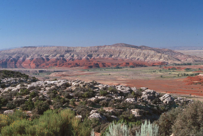
- The photo of the red and white cliffs above the Bighorn River is from the National Park Service. Used with thanks.