Medicine Wheel/Medicine Mountain: Celebrated and Controversial Landmark
The Medicine Wheel/Medicine Mountain National Historic Landmark is located at an elevation of 9,642 feet near the crest of the Bighorn Mountains of north central Wyoming. It occupies a rolling limestone plateau 30 miles east of Lovell, Wyo., and 12 miles south of the Montana border. It is an important prehistoric archeological landscape as well as an ancient Native American spiritual site where tribal ceremonial activity continues to this day. It was also a major historic preservation flashpoint that transformed public land management in Wyoming.
The Medicine Wheel was designated a National Historic Landmark in 1970 due to its unique scientific research values and to the overwhelming support of prominent Wyoming politicians. In 2011, the Landmark boundaries were substantially enlarged from 110 to 4,080 acres in response to an accumulating body of ethnographic information regarding Native American traditional cultural use of the Medicine Wheel and the surrounding landscape. The name of the Landmark was consequently changed to include reference to the larger Medicine Mountain area.
Researchers have identified as many as 150 medicine wheels in Montana, South Dakota, Wyoming and the Canadian provinces of Alberta and Saskatchewan. The Bighorn Medicine Wheel is unique among features of this type. It is the best-known, and one of the largest and best preserved on the northern and northwestern Plains. It was the first medicine wheel to be mentioned in popular literature and the first to be studied by the professional scientific community.
Euro-American science and Native American traditions
Most medicine wheels are found in southern Alberta and Saskatchewan. The oldest is the 5,500-year-old Majorville Cairn in Alberta. The Bighorn Medicine Wheel, probably less than 1,000 years old, was first studied in 1902 by the noted ethnologist S. C. Simms on behalf of the Chicago Field Museum.

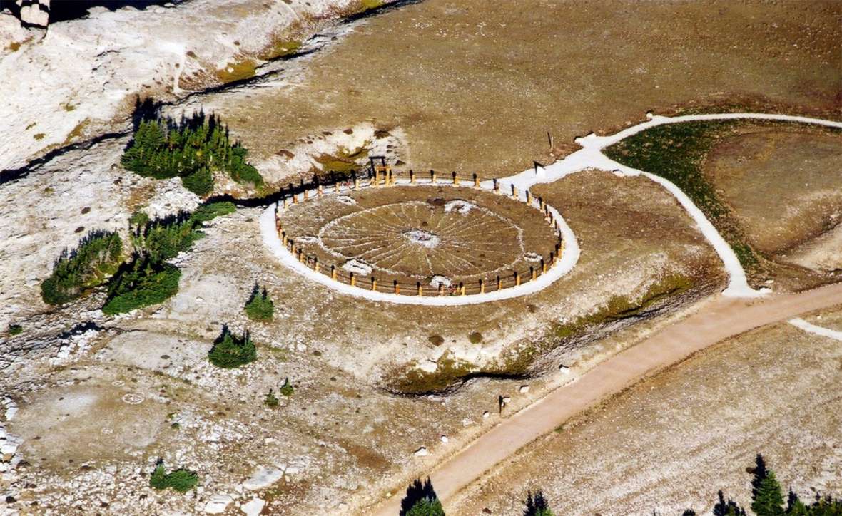
The Medicine Wheel is a circular alignment of limestone boulders about 80 feet in diameter with 28 rock “spokes” radiating from a prominent central cairn. Five smaller stone enclosures are connected to the outer circumference of the wheel. A sixth and westernmost enclosure is located outside the circle of the wheel but is clearly linked to the central cairn by one of the spokes. The enclosures are round, oval, or horseshoe-shaped, and closely resemble northern and northwestern Plains vision-quest or fasting structures.
In the early 1970s, astronomer and solar scientist John Eddy noted several important star alignments involving the central and circumferential cairns. He suggested that the Bighorn Medicine Wheel was probably used by prehistoric Native Americans as an ancient astronomical observatory and calendar.
The surrounding landscape contains numerous historic and prehistoric sites that include tipi rings, small chipped-stone scatters, buried archeological sites, and a system of prehistoric Indian trails all superimposed by a century of non-Native use by loggers, ranchers, miners and recreationalists.
There are also many contemporary Native American traditional use areas and features throughout the area. These include ceremonial staging areas, medicinal and ceremonial plant-gathering areas, sweat lodge sites, altars, offering locales, and recent vision-quest enclosures. Many of these traditional use areas coincide with prehistoric sites containing poorly defined rock alignments that probably relate to earlier ceremonial or spiritual use.
Attempts to date the Medicine Wheel
Archeologists generally believe that the Medicine Wheel is a Late Prehistoric composite feature constructed over several hundred years. During excavations conducted in 1958 by the Sheridan Chapter of the Wyoming Archaeological Society, ceramic sherds associated with the Shoshone and Crow tribes were recovered from the eastern half of the Medicine Wheel. Early 19th century glass trade beads were found near the central cairn and a wood sample from one of the cairns was tentatively dated to 1760 A.D. by means of tree-ring dating.
Subsequent researchers recovered hearth charcoal and preserved wood fragments from nearby archeological sites that yielded radiocarbon dates ranging from about 6,550 years ago to the modern era. Most diagnostic artifacts and other archeological materials found near the Medicine Wheel tend to date to the latter half of the Late Prehistoric Period, from about 900 A.D. to 1800 A.D. Although these artifacts and radiocarbon dates fail to decisively explain the construction and use of the Medicine Wheel, the collective evidence indicates that the Medicine Mountain area was used by prehistoric Native Americans for nearly 7,000 years.
Whether or not this prehistoric occupation and use was predominantly ceremonial or spiritual—with the Medicine Wheel/Medicine Mountain as the central focus—is speculative in ways that archeological data probably won’t be able to resolve. Clearly, though, the Medicine Mountain area was known to prehistoric Native Americans long before the Bighorn Medicine Wheel itself was constructed.
Tribal affiliations
Assigning tribal affiliation to the Bighorn Medicine Wheel by archeological means is a matter of inference rather than fact. As mentioned previously, ceramics recovered from the interior of the wheel have been identified as Shoshone and Crow in origin. Several researchers have noted archeological evidence supporting an extensive Crow presence on the western slopes of the Big Horn Mountains that began in the latter part of the 16th century and possibly earlier. Evidence of a substantial Shoshone occupation can be seen in the adjacent Bighorn Basin. Horseshoe-shaped enclosures like those found in direct association with the Medicine Wheel have been associated with Crow fasting or vision-quest rituals.
Based on ethnohistorical research and a careful review of Eddy’s astronomical observations, anthropologist Karl Schlesier has suggested that the Bighorn Medicine Wheel and the Moose Mountain Wheel in Saskatchewan express star alignments associated with Cheyenne ritual use.
Ethnographic evidence substantiates that the Medicine Mountain landscape is, and has been, a major ceremonial and traditional use area for many regional Indian tribes. Traditional practitioners from the Arapaho, Bannock, Blackfeet, Cheyenne, Crow, Kootenai-Salish, Plains Cree, Shoshone and Sioux tribes generally venerate this landscape because it embodies uniquely important and powerful spiritual principles that figure prominently in tribal and family ceremonies. To these Native Americans, the rock alignments and cairns found on Medicine Mountain are religious architecture, not anthropological data. Most knowledgeable Indian traditional practitioners regard the Medicine Wheel as an essential but secondary component of a much larger spiritual landscape composed of the surrounding alpine forests and mountain peaks.
Native American oral traditions
Native American oral traditions and ethnohistory are also relevant to the issue of the origins and use of the Medicine Wheel. One Crow legend recounts the construction of the Wheel by Burnt Face, who fasted there in order to heal his disfigurement. In the Blackfeet version of this narrative, Scar Face traveled to the Wheel in the distant past, where his scarring was miraculously removed. He was given instructions for building a sweat house and conducting the sun dance, information which he carried back to his tribe.
Early ethnographic interviews and depositions are also informative. The Crow Indian Flat-Dog reported to anthropologist Robert Lowie that the Medicine Wheel was the “Sun’s Lodge,” that many Crow went there to fast, and that the structure was very ancient. When interviewed by anthropologist and naturalist George Bird Grinnell in 1921, an elderly Cheyenne named Elk River compared the Wheel to the Cheyenne sun dance lodge. Anthropologist James Howard cited an ethnohistorical transcription in which John Bull, a Ponca chief, testified that the Medicine Wheel “represents a sun dance circle.”

Native American oral traditions also clearly affiliate the Bighorn Medicine Wheel and Medicine Mountain with several prominent Indian chiefs. Plenty Coups was the last hereditary chief of the Mountain Crow tribe as well as the most prominent Crow statesman during the late 19th and early 20th centuries. According to Crow oral traditions, Plenty Coups fasted at the Bighorn Medicine Wheel—once with Chief Joseph of the Nez Perce. Chief Joseph is perhaps best known for leading his band of 700 Nez Perce in a desperate, brilliant, and ultimately futile military campaign designed to withdraw his tribe in 1877 to a Canadian sanctuary among the northern Sioux. Chief Washakie, the celebrated head chief of the Eastern Shoshone until his death in 1900, reportedly acquired much of his power at the Medicine Wheel and was sometimes joined in prayer there by the Crow.
Medicine Mountain in local Euro-American history
To many long-term Euro-American residents of the northern Bighorn Basin, Medicine Mountain and the Medicine Wheel represent a popular and highly valued recreational destination for camping, hunting, fishing, and picnicking. The first documentary reference to the Wheel occurred in 1895, when Paul Francke described his hunting exploits in an article published in Forest and Stream.
At one time the site locale contributed significantly to the local economy. At the turn of the 20thcentury, miners and loggers harvested resources near the Medicine Wheel, and the resident bighorn sheep were soon hunted to extinction. Later, the area served as an important summer range for domestic sheep and cattle.
Boy scouts from the nearby town of Lovell built a protective rock wall around the Medicine Wheel sometime in the mid-1920s. The rock wall was later replaced with a galvanized steel mesh fence capped with barbed wire, which was subsequently replaced by the low exclusionary post-and-ropes fence seen today.
The historic-era imagery of the resourceful logger, miner, and rancher living close to the land in a visually inexhaustible wilderness setting remains a powerful image to local Euro-Americans, who have always expressed a very personal and proprietary interest in the Medicine Wheel.


Recent administrative history
The Medicine Wheel remains Wyoming’s most complex, acrimonious, and protracted historic preservation case. Disputes involved difficult negotiations over more than 20 years among numerous government agencies and traditional elders representing 16 Indian tribes. The deliberations decisively changed the practice of cultural resource management in Wyoming by demonstrating the benefits of tribal consultation to both Native Americans and Euro-Americans.
The bureaucratic history of the Bighorn Medicine Wheel is part of a larger narrative that charts the slow shift from public resource extraction to resource protection over the past half-century. Current federal management of the Medicine Wheel/Medicine Mountain landscape is largely the outcome of negotiations that began in 1988, when officials from the U.S. Forest Service proposed changes designed to accommodate and encourage tourism at the Landmark.
Initially, the Forest Service proposed building a large parking lot, a viewing tower, and a modest visitor center all within about 100 meters of the wheel. Members of the Native American traditional community objected strenuously. They were soon joined by a growing assembly of historic preservation agencies and natural-resource advocacy organizations that uniformly opposed the planned construction.
These groups maintained that the construction would seriously impact the scientific and cultural values embodied by the Landmark. In contrast, local Euro-American communities generally welcomed the U.S. Forest Service proposal, and viewed it as a powerful development initiative that would benefit local economies.
In 1994, tribal representatives, federal and state government administrators, and local elected officials began work on a historic preservation plan. The work proceeded slowly due to endless revisions as well as initial hostility and mistrust among the consulting parties. The resulting plan, executed in September 1996, was a compromise that reflected the diverse and contending interests of the consulting parties. The plan articulates the provisions and protocols by which the Bighorn Medicine Wheel/Medicine Mountain is managed today.
The document established a 23,000-acre “area of consultation” that encompassed all archeological sites and Native American traditional use areas associated with the Bighorn Medicine Wheel. The plan facilitates traditional cultural use by Native American practitioners by providing for both scheduled and impromptu ceremonial use.
The plan also mandated comprehensive site monitoring using well-defined baseline data, and required close cooperation among the consulting parties with regard to public visitation impacts and land-development issues. Vehicular access is generally prohibited, and visitors are required to walk one and one-half miles each way to visit the Bighorn Medicine Wheel. Exceptions are made for disabled and elderly visitors.
In 2011, as previously mentioned, the boundaries of the Medicine Wheel/Medicine Mountain National Historic Landmark were enlarged to include not only prehistoric archeological sites, but also to accurately and fairly represent Native American cultural values closely associated with the entire Medicine Mountain landscape. Tribal consultation increased our awareness that the past survives, and is much more than a sterile recitation of scientific observations and nearly forgotten events. Native Americans are still here, among us, and their traditional knowledge can help us understand Wyoming’s history and prehistory in compelling new ways.
Resources
Sources
- Brumley, John H. “Medicine Wheels of the Northern Plains: A Summary and Appraisal.” Manuscript Series 12. Archaeological Survey of Alberta, Edmonton, 1988.
- Campbell, Gregory, James P. Boggs, and Fred Chapman. “Medicine Wheel/Medicine Mountain National Historic Landmark Nomination,” Wyoming State Historic Preservation Office, 2011. Accessed February 2019 at http://wyoshpo.state.wy.us/index.php/programs/national-register/wyoming-listings/view-full-list/411-medicine-wheel-medicine-mountain-national-historic-landmark.
- Chapman, Fred. “The Bighorn Medicine Wheel: Landscape Wars and Negotiating Native American Spirituality in the New West.” In Preserving Western History, edited by Andrew Gulliford. Albuquerque: University of New Mexico Press, 2005.
- Connor, Stuart W. “Archaeology of the Crow Indian Vision Quest,” Archaeology in Montana 23(3), 1982: 85-127.
- Eddy, John A. “Probing the Mystery of Medicine Wheels,” National Geographic Magazine 151(7), 1977: 140-146.
- Grey, D. “Big Horn Medicine Wheel Site, 48BH202,” Plains Anthropologist 8(19), 1963: 27-40.
- Grinnell, George Bird. “The Medicine Wheel,” American Anthropologist 24(3), 1922: 299-310.
- Liebmann, Matthew. “Demystifying the Big Horn Medicine Wheel: A Contextual Analysis of Symbolism, Meaning, and Function,” Plains Anthropologist 47(180), 2002: 46-56.
- Simms, S. C. “A Wheel-Shaped Stone Monument in Wyoming,” American Anthropologist, 5(1), 1903: 107-110.
Illustrations
- The Bighorn National Forest aerial photo of the Medicine Wheel is from the final National Historic Landmark nomination for the Medicine Wheel, completed in 2011. Used with thanks.
- The photo of the Shoshone village near South Pass, 1870, is by William Henry Jackson. Used with thanks.
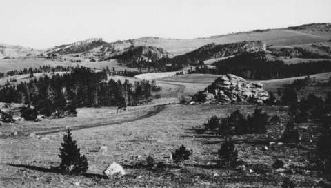
- The 1934 photo of the landscape around the Medicine Wheel was taken by Seymour Bernfeld. It and the photo of archeological work underway at the Medicine Wheel by the Sheridan Chapter of the Wyoming Archeological Society are from the American Heritage Center at the University of Wyoming. Used with permission and thanks.
- S.C. Simms’ closeup of the cairn is from the Field Museum of Natural History. Used with thanks.
- The black-and-white photo of the Medicine Wheel showing the rock wall was taken in the 1920s by T.J. Dunnewald, a soils scientist from the University of Wyoming. Author’s collection, used with thanks.
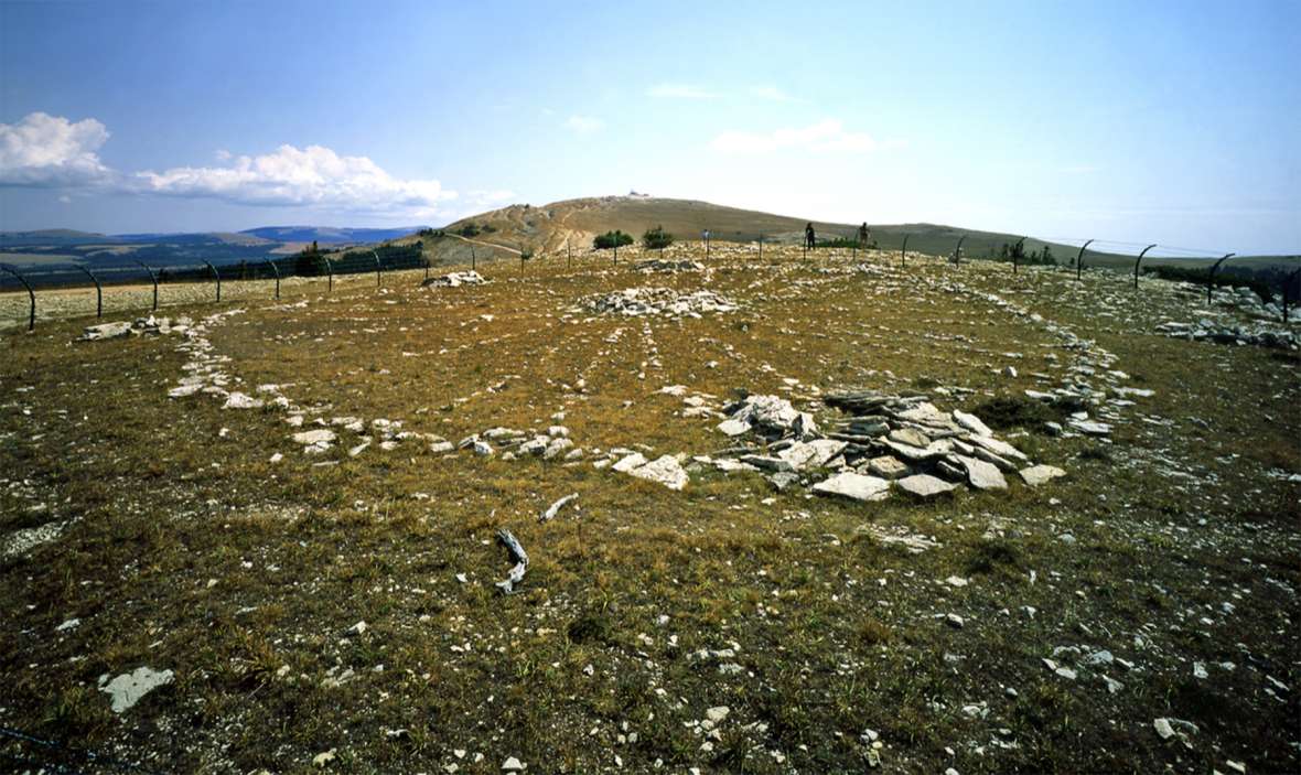
- The ground-level color photo looking east toward Medicine Mountain is by Richard Collier of the Wyoming State Historic Preservation Office. Used with permission and thanks.
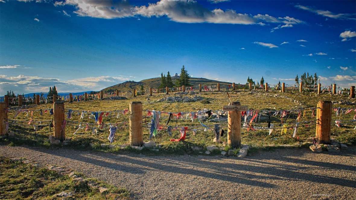
- The photo of the Medicine Wheel today is by Robert Clayton of rocdoctravel.com; the site contains more great photos of the Medicine Wheel and the landscape and geology around it—and around the West. Used with permission and thanks.