Rivers, Mountains and Plains: The Raynolds Expedition of 1859-1860
Capt. William F. Raynolds stood on the dock at St. Joseph, Missouri, on June 4, 1859, waiting to board the steamboat Spread Eagle. As he stepped onto the deck, greetings came from the men he had selected to staff an exploration party headed up the Missouri River. Standing quietly out from the assembled soldiers, scientists and artists and dressed comfortably in frontier garb was the famed mountaineer, Jim Bridger. What better advisor and guide could they have?
Less than two months earlier, Raynolds, stationed in Florida, received orders to “organize an expedition for the exploration of the region of country through which flow the principal tributaries of the Yellowstone river, and the mountains in which they, and the Gallatin and Madison forks of the Missouri, have their source.” He was to ascertain the “numbers, habits and disposition of the Indians inhabiting the country, its agricultural and mineralogical resources,” its climate, navigability of its rivers, topography and any likely obstacles to the building of roads or railroads.
In particular, he was to determine the three best routes from Fort Laramie to the Yellowstone toward Fort Union in what’s now far northwestern North Dakota; from Fort Laramie northwest along the Big Horn mountains towards Fort Benton and the Bitterroot valley; and from the Yellowstone to South Pass, and to determine “the practicability of a route from the sources of Wind river to those of the Missouri.”
To accomplish all this, Raynolds was authorized to hire eight assistants, gather scientific instruments and other supplies, with the promise of logistical support from Army and fur-trade posts along the way. He was to be provided with an escort of 30 infantrymen. Cost of the expedition was limited to $60,000. To Raynolds’s frustration, the secretary of war ordered him to take a small group of civilians who had no apparent duties.
Capt. Raynolds was a member of the Corps of Topographical Engineers, a small military branch that since 1838 had been at the center of scientific exploration of the West. He was quite aware of earlier expeditions to the West from Lewis and Clark to John Charles Fremont and the surveys in the 1850s designed to assess the best possible routes for a transcontinental railroad. Between 1855 and 1857, Lt. G.K. Warren had entered what are now the Dakotas and Montana and had also recommended and originally was to lead what became Raynolds’ expedition. Raynolds knew that he would be examining country not formally explored and documented by his government predecessors. Yet, he would follow trails and paths of Native people who had inhabited the region for centuries. Fur brigades and trappers had also lived and worked in the same plains and mountains for decades before 1859, and knew them well.

But Raynolds’ survey was meant to provide the detailed documentation that could lead to the building of roads, the exploitation of natural resources and ultimately the dispossession of the Plains and mountain tribes.
|
Image
|
|
Image
|
|
Image
|
Assisting Raynolds was 1st Lt. Henry E. Maynadier, heading up a second division of the expedition. Assistants with critical experience and knowledge included James D. Hutton, topographer and assistant artist/photographer; J. Hudson Snowden, topographer; Anton Schönborn, meteorologist and artist; Dr. M.C. Hines, surgeon and assistant naturalist; and Dr. Ferdinand V. Hayden, naturalist, geologist and surgeon. Hayden had notable experience in Western exploration and with Snowden had been with the earlier Warren expeditions.
Heading West
The steamboat paddled up the Missouri to Fort Randall in present South Dakota, where it arrived on June 13. There, 30 men and Lt. Caleb Smith of the 2nd U.S. Infantry joined them as their escort. Five days later at Fort Pierre, Raynolds met with principal Lakota Sioux chiefs Bear Rib of the Hunkpapas and Two Bears of the Yanktonais to distribute annuity goods and hopefully gain support for his incursion onto Lakota lands.
For nearly two months after departing from Fort Pierre, the expedition moved by land to the west, then north. Barely mentioned by Raynolds is that in traversing the Black Hills, topographer and artist James Hutton, with a part-Yanktonais interpreter named Zephyr Rencontre, reached Bear Lodge (Devils Tower). Hutton and Rencontre were the first documented government officials to do so.
Along the way, Raynolds characterized much of the land as desolate, noting from one observation point that their view “was grand, though uninviting from the appearance of desolation and the hardships threatened in our future marches.” The opinionated captain was also highly religious and slowed progress by requiring rest every Sunday; he offered prayer services to men willing to attend.
Moving slowly but purposefully, they passed into buffalo range in what we know of as southeastern Montana, explored along Powder River and crossed the Tongue and Rosebud rivers. An odometer attached to a cart measured distance; sextants, barometers, chronometers, compasses, artificial horizons and other instruments allowed them to record weather conditions, temperatures, longitudes, latitudes and altitudes.
On July 21, terror and humor collided when three buffalo bulls charged the party. One of the soldiers, Raynolds later reported, “dropped his gun, and, raising his hands, exclaimed, in all the accents of mortal terror, ‘Elephants! Elephants! My God! I did not know that there were elephants in this country!’”
Running short of supplies, they finally met up with American Fur Company trader Robert Meldrum who brought goods by boat from the Yellowstone up the Rosebud. The expedition then found its way along the north side of the Yellowstone River in present south-central Montana to Fort Sarpy at the confluence with the Bighorn River, where it was able to fully resupply. At this time they also met in council with the Crow.
Returning south across the future Wyoming border, Maynadier split from the command to explore the Tongue River, and Raynolds’ group followed the Bighorn River into a region that Jim Bridger “seems to know every square mile of,” Raynolds reported.
Raynolds viewed areas that would make a natural highway, some of which, a few years later, would become the short-lived Bridger Trail for Montana-bound gold seekers. Following the river and skirting Bighorn Canyon, Raynolds described the area as “one of the most remarkable sights upon the continent.” Residents of Lovell, Wyo., and visiting tourists today, use similar adjectives to describe the dramatic Bighorn National Recreation Area.
Moving east and south, the expedition crossed the Tongue River, Goose Creek and Clear Creek near modern Sheridan and Buffalo, Wyo. Storms and fear of Indians slowed progress. Passing Lake DeSmet, they viewed Pumpkin Buttes in the distance to the east.
A day later, on Sept. 21, the column was greeted by three Arapaho men, one of whom, unexpectedly, spoke English. He went by the name of Friday. Years earlier, mountain man Thomas Fitzpatrick had found Friday when he was just a boy, eventually taking him to St. Louis where he attended school and became fluent in English. Friday informed Raynolds that Indian Agent Maj. Thomas Twiss had letters for him at Deer Creek. The column continued south, in search of a location to establish quarters for the winter. They headed for the “Platte road”—what we know today as the Oregon Trail.
To Winter Quarters
Raynolds naively asked Bridger if there was a danger of crossing the trail without knowing it. Soon enough, he learned it was unmistakable; the well-worn trail “gave evidence of the immense amount of travel that passes over it,” and he witnessed an ambulance wagon transporting a small group of women eastward to the states.
On Oct. 11, the command arrived at John Richard’s Upper Platte trading post near present Casper. Here, many of the men, especially the military escort, acquired liquor and became drunk and mutinous.
Lt. Smith refused to follow any orders from Raynolds, who observed that the drunkenness “converted the camp into bedlam.” Smith moved the escort’s camp without authorization, seriously compromising Raynolds’s authority. Drunkenness continued to pester the command through the winter. Raynolds soon traveled to Fort Laramie to arrange for supplies—and a court martial for Lt. Smith. But Smith was found innocent of drunkenness and mutiny because as an engineer officer, Raynolds did not have clear authority over the infantry escort. He made do without an escort until the spring.
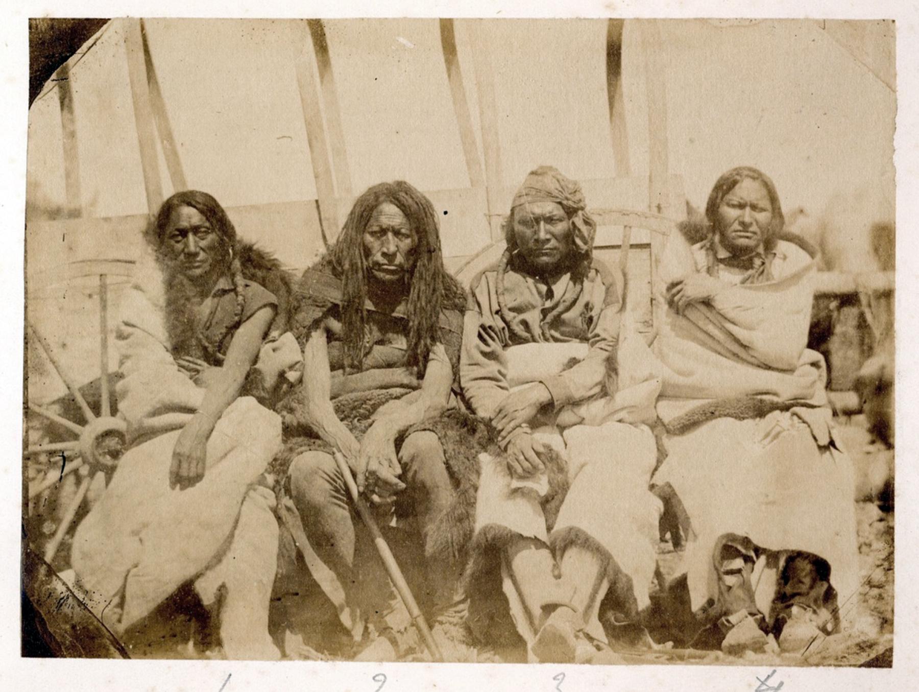
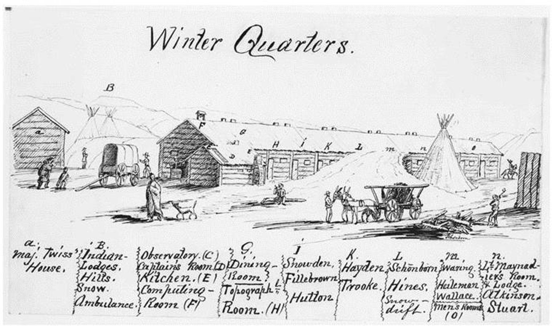
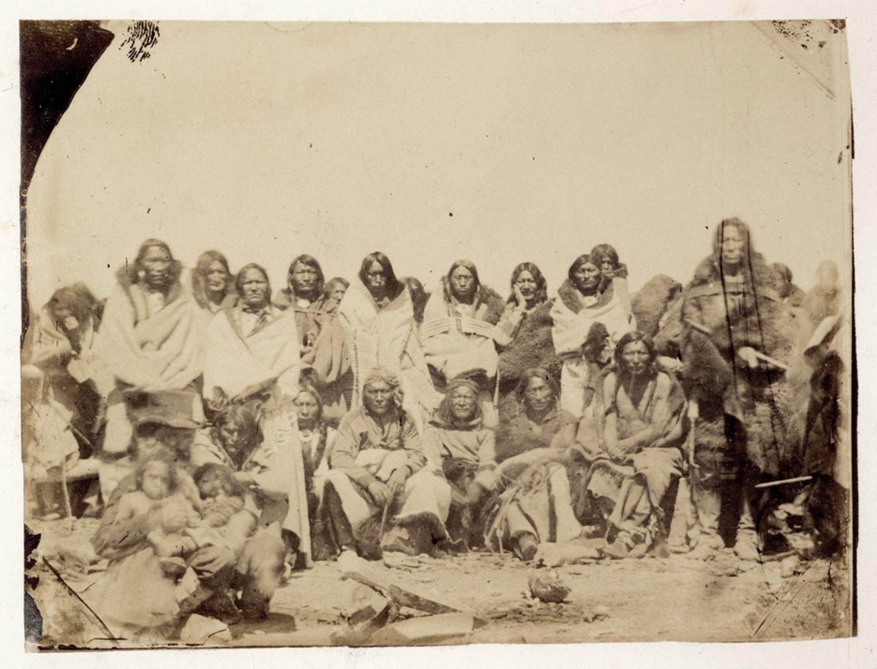
Reuniting with Maynadier’s command, the Raynolds expedition settled in abandoned Mormon buildings at Deer Creek near present Glenrock, Wyoming. Here, James Hutton photographed Arapaho leaders and many of the men with the 180 lodges of their people who met with Agent Twiss.
Raynolds and his men spent the winter working on notes and maps, duplicating their reports and mailing them to Washington. With Maj. Twiss, Raynolds worked to get an appointment for Joseph Bissonette as postmaster at his trading post at Deer Creek. With the regular mail service that resulted, they were only two weeks from up-to-date news from the East. Starting in April, they witnessed the drama of mail-carrying Pony Express riders dashing through the settlement.
Raynolds continued to offer Sunday religious services, even hosting a Christmas celebration with German-speaking Lutheran missionaries headquartered at the same location. The Lutherans did not have sufficient funding or supplies; Raynolds, Hayden, Schönborn and other members of the expedition took up a collection to help pay their expenses.
During the winter, three smaller exploratory surveys were launched from Deer Creek. J.H. Snowden led one examining the country between Deer Creek and the Black Hills of what’s now South Dakota. James Hutton sought a more direct route to Powder River for a possible wagon road to Fort Benton in future Montana.
The winter stop also allowed Hayden to venture south, examining geological features of the land from Deer Creek nearly to Long’s Peak and Pike’s Peak on the Colorado front range. This excursion allowed for documentation along the Laramie range and across the Laramie Plains to the valley of the Cache la Poudre. Observations about the Medicine Bow and Sweetwater mountains were also included in his report.
Planning for the coming summer, Raynolds also received orders to head for Canada in July to observe a total eclipse of the sun! The orders were not practical; he had to concentrate on accomplishing his other objectives.
Bridger had spent the winter with family in Missouri, returning by stagecoach in the spring and enticing Raynolds with stories of what they might see heading north and west. He described “marvelous tales of burning plains, immense lakes,” and one story “described an immense boiling spring that is a perfect counterpart of the Geysers of Iceland.” On May 10 they moved towards the Yellowstone country.
Back on the Trail
A new military escort under Lt. John Mullins with 30 mounted dragoons now joined the survey to provide protection for the command. Maynadier followed a route past Independence Rock going west and then northwest along the Wind River. Raynolds crossed the Rattlesnake Hills, and went on to pass near modern Lysite and Shoshoni, Wyoming. Moving along the Wind River to near present Riverton, Wyoming, he crossed Maynadier’s tracks, then went northwest up the Wind River past what we know of as Dubois.
Even by late May, Raynolds faced an impenetrable snow-covered landscape. He gave up on moving into Yellowstone and being able to confirm Bridger’s wild tales of the land. Jim Bridger informed him, “I told you, you could not go through. A bird can’t fly over that without taking a supply of grub along.”
The expedition continued through portions of present Wyoming turning briefly south, crossing the continental divide on May 31. Raynolds recorded in his journal that 10 miles from their route was a peak “I regard as the topographical center of the continent . . . . I named it Union peak, and the pass Union pass.” It was a name heavy with meaning; the Civil War would break out in another 10 months.
They then began moving west down the valley of the Gros Ventre River. Moving slowly, they entered Jackson Hole on June 11. A week later they crossed Teton Pass, entered present Idaho camping in Pierre’s Hole on the west side of the Tetons and then moved north. Although at one point they were as close as 40 miles to Old Faithful, they were not destined to view any of the thermal features of Yellowstone.
They saw much more of what became Montana, eventually reaching the Three Forks of the Missouri, reconnecting with Maynadier, and moving east, finally abandoning the impractical orders to witness the solar eclipse in Canada.
Again, they separated into two columns. Maynadier followed the Yellowstone to its confluence with the Missouri at Fort Union. Raynolds headed for Fort Benton, head of steamboat navigation on the Missouri, and ultimately followed that river east and south to Fort Randall, covering 550 miles in 34 days. The expedition disbanded at Omaha, Nebraska Territory, and Raynolds sold the animals and equipment that served them.
Results of the Expedition
Raynolds Expedition was the last one led by the Corps of Topographical Engineers. It was the first government expedition through Jackson Hole. They traveled more than 2,500 miles and charted a region of nearly 250,000 square miles. Much of what’s now northern Wyoming had not been previously documented. Their topographical, meteorological and barometric notes enlightened science; this was the first careful study of the region’s geography. They gathered a large collection of fossils and botanical specimens that informed the studies of scholars in the East.
With the election of Abraham Lincoln and the beginning of the Civil War, Raynolds, Hayden, Maynadier and others began military service for the Union. A few, including Hutton and Mullins, joined the Confederates. Although Raynolds began work on his report, publication was delayed until 1868. Preliminary reports to the secretary of war in 1859 and 1860 were available, but received little public note.
Hayden published reports on geography and other aspects of his work, but these too, because of the war, had less impact than they would have otherwise. Raynolds submitted his map of the tour in 1864, but this and the report of Henry Maynadier published that year were too late to have an immediate impact on travel to the new Montana gold fields. Raynolds' recommendations for a road north from Deer Creek were not generally available until after John Bozeman independently developed his trail along the same basic route.
A major shortcoming of Raynolds’ report is that it did not include important photographs and drawings made by Anton Schönborn and James Hutton. Their work included the first artistic images of many areas—including the Teton Range, Bighorn Canyon and the Deer Creek community.
Seven of the many photographs of Native people were published as lithographs by Hayden in 1863, marking the first field photographs of Western Indians to be so revealed and predicting the work of many expeditions and photographers to follow.
One assumes that more should have been revealed of this material. Schönborn committed suicide in 1871, but three of his drawings made into lithographs were published by Hayden in 1883. Raynolds himself admired Schönborn’s work but thought little of Hutton and his photographs and indeed the quality of the photos done with bulky glass plate equipment leaves much to be desired.
It is unfortunate that the Raynolds Expedition did not explore the upper Yellowstone River and the region that would become Yellowstone National Park. The experience did prime Ferdinand Hayden to lead expeditions between 1868 and 1872 that conducted detailed assessments of the region, leading to the creation of Yellowstone National Park.
In fact, the Raynolds Expedition was a failure. If not for the Civil War, the expedition report could have been published sooner and had a more immediate impact on transportation to and settlement in areas we know today as Wyoming and Montana. Even so, Raynolds' report and maps when finally published were a notable contribution providing public information on major rivers, valleys and other features of the newly established Wyoming Territory. They were the first publications naming many parts of the region including Heart Mountain and Union Pass and stood as the most important sources of the kind until the 1870s.
The original goals of the expedition clearly were accomplished, locating natural resources and routes for roads, commerce and settlement. If anything, the map showed a place frozen in time, a home to Native people. But the map was a tool in the process of the region’s becoming defined, claimed and dominated by newcomers filled with the nation’s self-perception of “Manifest Destiny.” In 1868 at Fort Laramie, the tribes ceded huge tracts of their land to the U. S. government for exploitation and settlement. The same year the report and map were published, Wyoming officially became a territory.
[Editor’s note: Special thanks to the Wyoming Cultural Trust Fund for support that in part made this article possible.]
Resources
Primary Sources
- Hayden, Dr. F. V. Ethnography and Philology of the Indian Tribes of the Missouri Valley. Philadelphia: C. Sherman & Son, Printers, 1862, 322, accessed Feb. 1, 2023 at https://archive.org/details/bp_1346547/page/323/mode/2up.
- Hayden, Ferdinand V. On the Geology and Natural History of the Upper Missouri. Transactions of the American Philosophical Society, 1862 12, no. 1 (1862): 1-218, accessed, 2023 at https://www.jstor.org/stable/1005249.
- ________________. “Sketch of the Geology of the Country about the Head-Waters of the Missouri and Yellowstone Rivers.” American Journal of Science 31, 2nd series, no. 92 (1861): 229-245.
- ________________. Twelfth Annual Report of the United States Geological and Geographical Survey of the Territories. Washington, D.C.: U.S. Government Printing Office, 1883.
- Humphreys, A.A. Annual Report, Topographical Engineers, In Charge of Office of Explorations and Surveys, November, 1859. Report of the Secretary of War, 36th Congress, 1st Session, Senate Ex. Doc. No. 2: 540-551.
- Map of the Yellowstone and Missouri Rivers and their tributaries: explored by Capt. W.F. Raynolds, Topl. Engrs. and 1st. Lieut. H. E. Maynadier, 10th. Infy. Assistant. 1859-60. United States. War Department. [Washington, D.C. : U.S. War Dept., 1868]. Library of Congress, Geography and Map Division. https://www.loc.gov/resource/g4127y.ct002286/?r=0.444,0.521,0.112,0.043,0, accessed May 26, 2023.
- Maynadier, Henry E. Memoir of the Country About the Heads of the Missouri and Yellowstone Rivers with A Plan for connecting It By a Military Road with the Platte Road. Washington, D.C.: Gibson Brothers, Printers, 1864, in comp. David A. White. News of the Plains and Rockies, 1803-1865. Spokane, Wash.: The Arthur H. Clark Company, 1998: vol. 5, 396-402. 473-483.
- Raynolds, Capt. W.F. Preliminary Report of Capt. W. F. Raynolds, Topographical Engineers. Report of the Secretary of War, 36th Congress, 2nd Session, Senate Ex. Doc. No. 1, 1860: 146-156.
- ________________. Report on the Exploration of the Yellowstone River. Washington, D.C.: Government Printing Office, 1868, accessed Feb. 1, 2023 at https://babel.hathitrust.org/cgi/pt?id=mdp.39015011349597&view=1up&seq=7.
Secondary Sources
- Blevins, Bruce H. Mapping Wyoming. Mansfield Centre, Conn.: Martino Publishing, 2007.
- Doyle, Susan Badger, ed. Journeys to the Land of Gold. Volume 1. Helena, Mont.: Montana Historical Society Press, 2000.
- Enzler, Jerry. Jim Bridger, Trailblazer of the American West. Norman, Okla.: University of Oklahoma Press, 2021.
- Goetzmann, William H. Army Exploration in the American West, 1803-1863. New Haven, Conn.: Yale University Press, 1959.
- _________________. Exploration and Empire, The Explorer and the Scientist in the Winning of the American West. New York: Alfred A. Knopf, 1967.
- Lowe, James A. The Bridger Trail a viable alternative route to the gold fields of Montana Territory in 1864. Spokane, Wash.: The Arthur H. Clark Company, 1999.
- Merrill, Marlene Deahl and Daniel D., editors. Up the Winds and Over the Tetons, Journal Entries and Images from the 1860 Raynolds Expedition. Albuquerque: University of New Mexico Press, 2012.
- Sandweiss, Martha A. Print the Legend, Photography and the American West. New Haven, Conn.: Yale University Press, 2002.
- Schubert, Frank N. Vanguard of Expansion: Army Engineers in the Trans-Mississippi West, 1819-1879. Washington, D.C.: History Division, Office of Administrative Services Office of the Chief of Engineers, 1980, accessed Feb. 25, 2023 at https://www.nps.gov/parkhistory/online_books/shubert/index.htm.
- Trenton, Patricia and Peter H. Hassrick. The Rocky Mountains, A Vision for Artists in the Nineteenth Century. Norman, Okla.: University of Oklahoma Press, 1983.
Illustrations
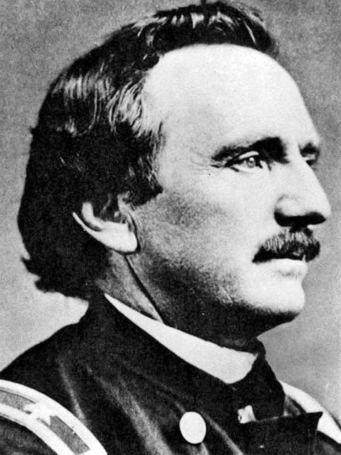
- The portrait of William Raynolds in Civil War uniform is from the J. Candance Clifford Lighthouse Research Catalog of the U.S. Lighthouse Society. Used with thanks.
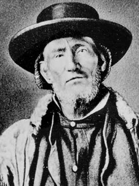
- The images of Jim Bridger and of Anton Schönborn’s sketch of Winter Quarters are from the American Heritage Center at the University of Wyoming. Used with permission and thanks.
- The color-coded map of the Raynolds Expedition’s various routes is by Margo Berendsen of the University of Wyoming’s Geographic Information Science Center. Used with permission and special thanks.
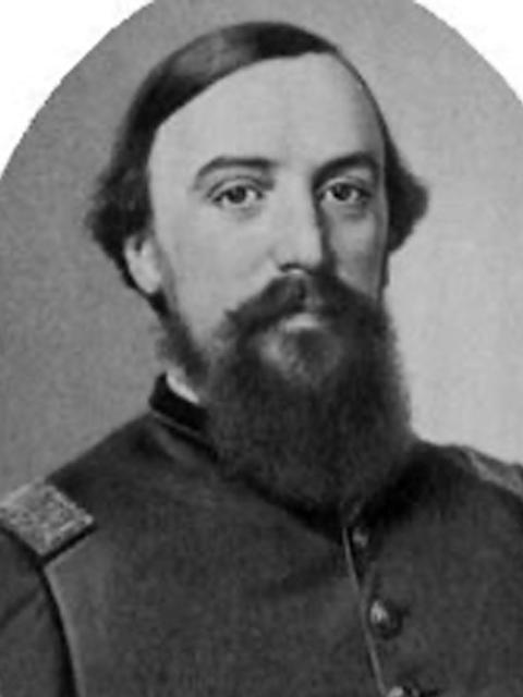
- The portrait of Lt. Henry Maynadier is from Generalsandbrevets.com, a now-defunct site that offered photos of Civil War officers. Used with thanks.
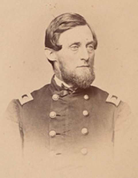
- The portrait of Ferdinand V. Hayden, geologist, naturalist and surgeon on the Raynolds Expedition and later one of the founders of the U.S. Geological Survey, is from the Smithsonian Institurion Archives. Used with thanks.
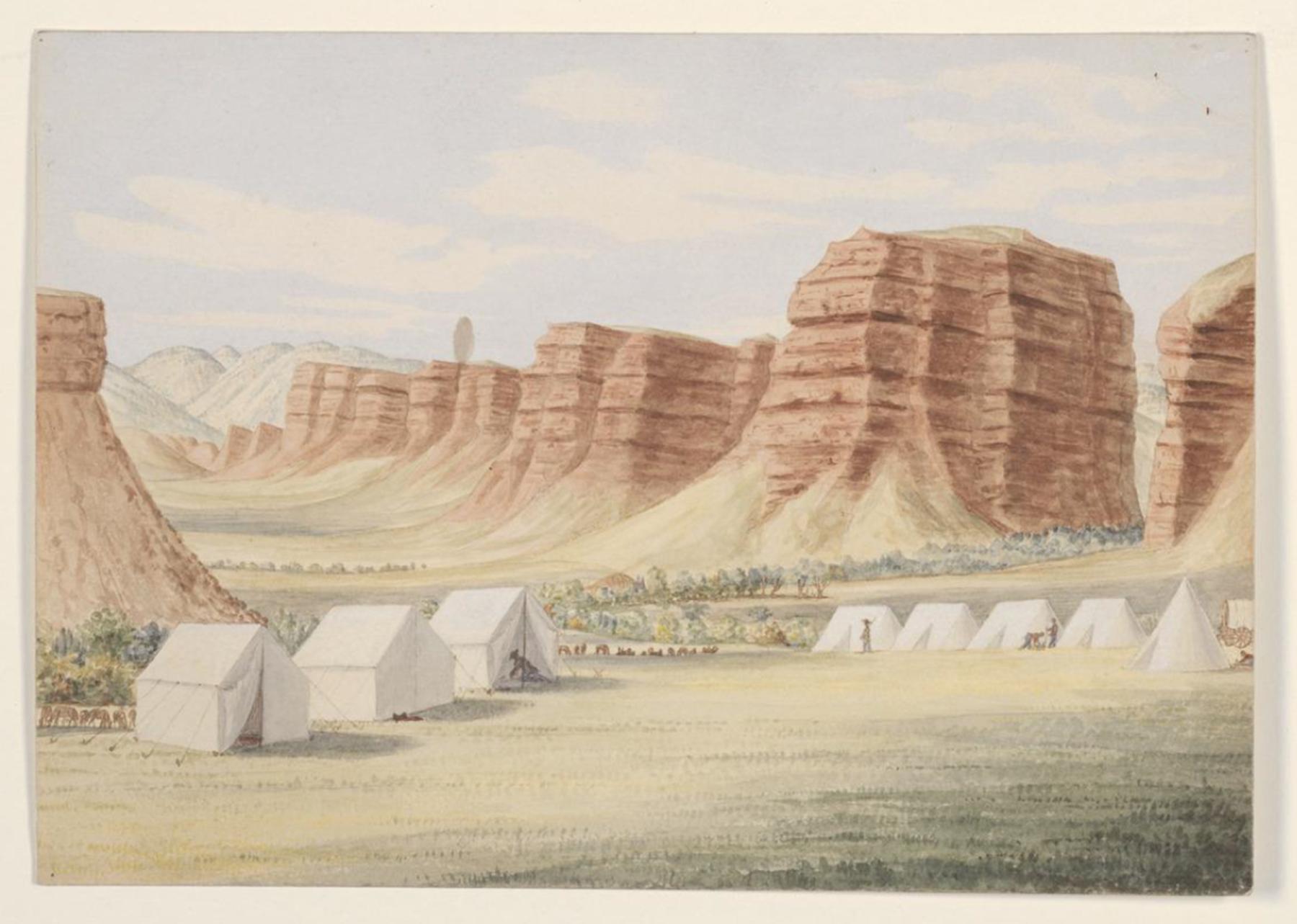
- Anton Schönborn’s watercolor sketch of the red bluffs on Powder River is from the collection of Raynolds papers in the Beinecke Rare Books and Manuscripts Library at Yale University. Used with thanks.
- The images of Schönborn’s paintings of the striped bluffs along Wind River, the Tetons and Jackson Hole from the Gros Ventre Valley, and Henry lake and the west side of the Tetons are all from a later USGS report, Twelfth Annual Report of the United States Geological and Geographical Survey of the Territories, 1883.
- The James Hutton photographs of four Arapaho men and of a larger group of Arapaho people, on Deer Creek in the fall of 1859, are from the William Blackmore Collection of the British Museum. Used with thanks.
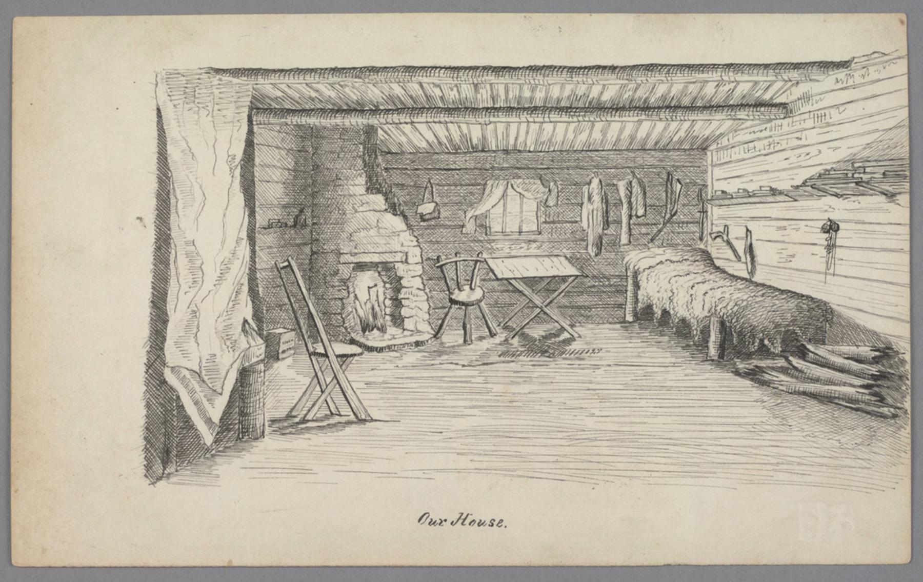
- Hutton’s sketches of the interior of his cabin at Winter Quarters, Inyan Kara Peak, badlands along Powder River, Bighorn Canyon, Clear Fork Canyon, Cloud Peak and the head of Wind River are all from the Huntington Library. Used with thanks.
- The image of original map of the Raynolds Expedition’s route is from the Library of Congress. Used with thanks.
- And finally, we send our special thanks to Margo Berendsen of the University of Wyoming’s Geographic Information Science Center for making the map of the expedition.