Park County, Wyoming
Prior to becoming a territory in 1869, the area now known as Wyoming was governed at various times by Nebraska, Idaho and the Dakota territories. By 1869 there were four Wyoming counties stretching from south to north: Laramie, Albany, Carbon and Carter, with an unorganized strip along the western border that the Territorial Legislature soon formed into Uinta County. Carter was first named for Judge W. A. Carter, the sutler at Fort Bridger, but the Legislature soon changed its name to Sweetwater. The Bighorn Basin, in the northwestern part of the territory, was located in Sweetwater County.
The basin had long been lived in or hunted in by various mountain and plains people, including Crow, Shoshone, Arapaho, Cheyenne, Lakota Sioux, Blackfeet and other tribes. The Fort Laramie Treaty of 1851 placed the area at the heart of country designated as Crow land. The Fort Laramie Treaty of 1868 left the basin bordered by a new Crow Reservation to the north and a new Shoshone Reservation to the south, while prohibiting non-Indians from coming onto the new reservations and settling there.
That still left most of the land in the Bighorn Basin open to white settlement, but it was not until the late 1870s that ranchers and others gradually began moving in. The land remained very sparsely populated for another 20 years or so.
In 1884, a growing white population led to the organization of Fremont County in what had been the northern end of Sweetwater County. This area included the Bighorn Basin. Six years later, the basin became part of Big Horn County when, just prior to Wyoming’s becoming a state, that county was authorized by the Eleventh Territorial Legislature. Big Horn County was finally organized in 1896, and Basin City became its county set.
Park County would eventually be created in 1909 out of the western half of Big Horn County. Small settlements throughout what is now Park County began to appear in the 1880s, however.
Early towns
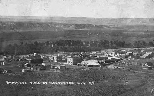
Meeteetse, a Shoshone word meaning “meeting place,” is located in the southern part of what’s now Park County and is home to the Pitchfork Ranch, one of the oldest cattle and sheep ranches in the basin, which was founded in 1879 by Count Otto Franc von Lichtenstein. At one time, the ranch covered 250,000 acres, but today it totals about 80,000. Residents first began to settle in the area near Meeteetse as early as 1887, although the town was not officially platted until 1896.
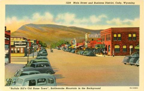
The town of Cody was founded in 1896 on what’s now called the Shoshone River, 53 miles east of Yellowstone National Park. The town’s seven founders made up the Shoshone Land and Irrigation Company, and the town was named for one of them, Col. William F. “Buffalo Bill” Cody. He promoted the town and the Bighorn Basin wherever he went, calling it a paradise with land suitable for farming and ranching, touting its proximity to Yellowstone, and the abundance of hunting and fishing opportunities.
In 1899, Buffalo Bill started the Cody Enterprise, the town’s newspaper. By 1901, the town was incorporated. That year, the Chicago, Burlington and Quincy Railroad line from Hardin and Toluca, Mont. reached Cody, bringing commerce from Montana and the Midwest and Yellowstone-bound tourists from everywhere.
By that time the town of Frannie, on the CB&Q line in Wyoming just south of the Montana border, was also a going concern. The town is named for the daughter of a cattle rancher in the area and is the only town to be named after a woman in the Bighorn Basin. Only the western side of Frannie is situated in Park County. The rest of this small community is in Big Horn County.
Garland, founded in 1901 about 17 miles south of Frannie and 30 miles northeast of Cody, was nicknamed the “Gate City,” because it was the CB&Q’s gateway town to the Bighorn Basin. For five years it was a booming town until the railroad extended its main line from Toluca to Worland, Wyo., bypassing Garland.
Ralston, Wyo., located between Cody and Powell and also founded as a railroad town, was platted in 1906 with town lots available for sale the following year. The town was either named for a worker on the CB&Q during construction of the spur line from Toluca to Cody in 1901, or for the owner of a bar at the townsite at the time.
Powell began in 1906 as a U.S. Bureau of Reclamation camp, first known as Camp Colter, for men working on the Garland Division of the Shoshone Project–the irrigation system that was so important to the survival and the success of the arid area. Four years later, the town was founded on that site and named for the “Father of Reclamation,” John Wesley Powell.
Founding of Park County
Eventually, there were enough settlers in the area—about 3,000—and a high enough total property valuation--$7 million-–required by the state of Wyoming to form Park County from Big Horn County. The Legislature authorized formation of the new county on Feb. 15, 1909, and by Jan. 9, 1911, the county was organized.
Some settlements came and went but others prospered and still exist today. In addition to Meeteetse and Cody, the communities of Powell, Ralston, Garland, the western part of Frannie and Clark were all established by the time Park County was created.
The county, covering 6,943 square miles, is situated between the Absarokas on the west and the Bighorn Mountains on the east. The highest elevation, 13,140 feet, is Franc’s Peak, named for Pitchfork Ranch founder Otto Franc. The climate of the county is arid, with rainfall averaging only 9.3 inches per year and snowfall averaging just 34.7 inches annually.
The main river in the county is the Shoshone River, which runs across the northern section from west to the northeast for nearly 100 miles, beginning near Yellowstone National Park and emptying into Bighorn Lake in Big Horn County. Originally, the river was called “Stinking Water” because of the sulfurous smell of the hot springs that flow into the river near Cody.
Dude ranching along the North Fork of the Shoshone River began officially in 1907 when the proprietors of Holm Lodge, located on the road to Yellowstone, began taking dudes and tourists into the park by horse and wagon to camp in tents for several weeks at a time. Dude ranching eventually became big business throughout the county as it did in the state and the region.
Courthouse and county government
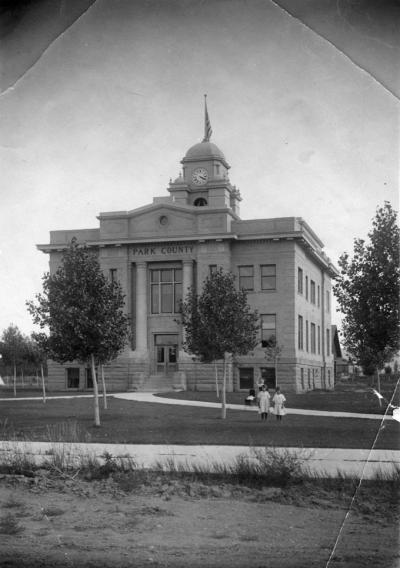
In 1909, the town of Cody was chosen as the Park County seat. County officials were elected in 1911. The first courthouse was a brick building on Rumsey Avenue known as the Spencer Building and now part of the Chamberlin Inn complex. The original structure was not large enough, however, to house the county offices for the 9 elected officials and their related staff. These officers were: sheriff, assessor, superintendent of schools, coroner, surveyor, attorney, treasurer, county clerk and clerk of district court. Voters elected three county commissioners in 1911. That number has changed from time to time and currently the commission has five members.
To fund the construction of a new courthouse and sheriff’s residence on land that was known as Arta Park in the middle of town, a controversial $45,000 bond issue was floated. The public questioned the large amount of money the county officials wanted to raise. Local newspapers tried to assure the public that in all likelihood not all the money would be used.
The bond issue passed in 1912 and a three-story courthouse and sheriff’s residence were built. The jail was located in one half of the building, and the sheriff and his family lived in the other half. Male prisoners were kept in the first floor cells, and the women were housed on the second floor.
Access to either jail area was available only from the outside. The exercise yard for the inmates was between the residence and the rear of the courthouse. The new building was ready for use in 1912. The courthouse tower sported a clock, donated by Cody resident and benefactor, William Robertson Coe, which is still operating today.
That jail continued to serve the County until the late ‘60s when a new jail was built on 11th Street and Beck, facing east. Once that was completed, Sheriff Harley Kinkade and his family moved into their apartment in the new jail, the parking lot behind the Courthouse was paved, and the old jail/sheriff’s residence was torn down.
Oil and gas
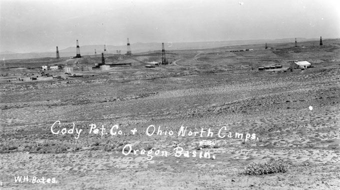
From its beginning, Park County’s economy has been dependent upon oil and gas production, agriculture and tourism. Several oil companies have operated here since the early discoveries in Oregon Basin southeast of Cody. Both gas and oil have come from several fields located in the area: Oregon Basin, 1912; Salt Creek, 1912 (not to be confused with the better-known Salt Creek Oil Field in Natrona County); the Big Gas field, Garland, 1915; and Elk Basin, 1916. While coal has also been produced throughout the county at Garland, Meeteetse and Oregon Basin, the amount has only been enough for local consumption.
In 1938, Canada-born businessman Glenn Nielson, found investors to help him buy what was then called the Park Refinery near the Cody railroad depot north of town. By 1952 Nielson’s firm was the publicly traded Husky Oil Company, headquartered in Cody with refineries and production in Canada and seven states. The Cody refinery finally closed in the mid-1980s. Since that time, Marathon has remained the dominant oil company in town.
Other enterprises
In 1917, the Pitchfork Ranch near Meeteetse acquired Timber Creek Ranch and made it the headquarters for dude ranching operations, which lasted until the late 1940s with a brief break during World War II. In 1926, the Dude Ranchers Association was started and the first president was Irving H. “Larry” Larom of Valley Ranch located in the upper Southfork, valley about 45 miles southwest of Cody.
Northwest College, a community college in Powell, was founded in 1953 and opened at its current site in 1956. The college now claims an enrollment of around 2,100 students.
The Wapiti area, west of Cody, is located on the road to the east entrance of Yellowstone National Park, and the Sunlight-Crandall area of ranches, dude ranches and summer homes lies in Sunlight Basin, northwest of Cody on the road to the northeast entrance to Yellowstone Park.
Heart Mountain Relocation Camp
During World War II, Wyoming was also home to the Heart Mountain Relocation Center, an internment camp located between Cody and Powell. The camp was one of ten in the United States mandated by Executive Order 9066 issued by President Franklin Roosevelt and the War Relocation Authority in February 1942. Japanese Americans, both citizens and non-citizens of the United States, who were living on the West Coast were ordered to leave their homes, their jobs and their possessions behind them and to report to assembly centers and eventually to internment camps in the interior of the country.
Heart Mountain, named for the distinctive landmark west of the camp, had its own school system, hospital, post office, newspaper and recreation areas—plus guard towers and barbed wire fencing to keep the internees inside the camp. From August 1942 until November 1945, Heart Mountain was a small town. Its population peaked at 10,872 people, making it the third largest town in Wyoming at the time.
Politics
As the county grew and prospered, some of the towns that were thriving in the early days later decreased in population--Ralston, Meeteetse, Frannie and Garland, for example. Others, such as Powell and Cody, grew.
Local politics got especially interesting in 1963, when a movement began in Powell to separate eastern portions of Park County from the rest, and form a new county. Some people in Powell felt that they were underrepresented in the state government because Cody received more governmental appointments and more revenue from the state. The new county, to be named Shoshone, would follow the boundaries of School District No. 1 on the eastern side of the county. Fortunately for the county, nothing came of this movement.
In 1983, because Park County’s government once again needed more office space, a new courthouse, supposed to replace the old one, was built. But a public outcry arose when locals realized that the original, historic courthouse was going to be demolished.
Protests were so vehement that the plans were changed to leave the two buildings standing side by side. The structures are connected in the interior, but the floors are misaligned. Additionally, the architectural styles are completely different, with one being classical and the other a version of the Prairie style made famous by Frank Lloyd Wright and others.
Irrigation
The irrigation of the Bighorn Basin has enabled farming and ranching to thrive. Cattle and sheep operations are scattered throughout the county while farming—particularly sugar beet, bean and barley production—is most predominant in the Powell area. The growing season in most of the county roughly May through September, but a little longer in the eastern side of the county.
Tourism
Park County’s proximity to Yellowstone has been an asset to the area since the national park was created in 1872. Buffalo Bill Cody was well aware of that when he first became interested in colonizing the area. The towns in the county have capitalized on this “Wonderland”—an early nickname for the park—from the beginning.
Cody is the closest town to the east entrance and focuses its attention on attracting tourists. The arrival of the railroad in 1901 spurred construction of the Irma Hotel (1902), the Wapiti Inn (1904), and Pahaska Tepee (1904). All were built to make it easier for tourists to visit Yellowstone. At first, the horse and wagon trip took two days but with the advent of the automobile and road improvements, tourists were able to reach Pahaska near the east entrance to Yellowstone in one day.
Park County continues to grow and prosper as the oil and gas industry does, for the most part. This has led to a prosperous county with good schools, libraries, law enforcement agencies, and fire departments. Tourism, recreation, ranching, agriculture and other industries plus a favorable tax situation–no state income tax and a four percent sales tax–make Park County a wonderful place to live or to visit.
Resources
- Cook, Jeannie, et al. Buffalo Bill’s Town in the Rockies. Virginia Beach, Va.: Donning Company Publishers, 1996, 18, 26-27.
- Feder, Barnaby J. “Glenn E. Nielson, 95, Builder Of Oil and Asphalt Business.” New York Times, Nov. 5, 1998. Accessed 5/31/12 at http://www.nytimes.com/1998/11/05/business/glenn-e-nielson-95-builder-of-oil-and-asphalt-business.html.
- Houze, Lynn Johnson. Images of America: Cody. Charleston, S.C.: Arcadia Publishing, 2008, 7-8, 82.
- Kensel, W. Hudson. Dude Ranching in Yellowstone Country; Larry Larom and Valley Ranch 1915-1969. Norman, Okla.: The Arthur H. Clarke Company, 2010, 167.
- Roberts, Phil, David L. Roberts and Steven L. Roberts. Wyoming Almanac, 4th ed., rev. Skyline West Press, Laramie, Wyo.: 1996, 297, 325.
- Wasden, David. From Beaver to Oil. Cheyenne, Wyo.: Pioneer Printing and Stationery Co., 1973, 105, 192-193, 282-286, 295.
Field Trips
- Sheridan Avenue, Cody’s main street, runs east to west and therefore directly to Yellowstone National Park, about 53 miles west. The motels, restaurants, shops and bars all cater to tourists.
- Other attractions include the Buffalo Bill Cody Stampede Rodeos over the 4th of July weekend, and the Cody Nite Rodeo nightly at 8:00 June through August, and the Irma Hotel at Sheridan Avenue and 12th Street, open 365 days a year for room guests and for breakfast, lunch, and dinner. For more information on these and many other opportunities, visit the Cody Chamber of Commerce at www.codychamber.org.
- Central to the agricultural past and present of Park County is the Shoshone Irrigation District; click here for more on the history of the district.
Illustrations
- The ca. 1920 photo of the Park County Courthouse is from the Park County Archives. The photo of the courthouse today is by the author. Used with permission and thanks on both counts.
- The photo of early Meeteetse is from the Wyoming State Archives, via Wyoming Places. Used with thanks.
- The early photo of the Oregon Basin oil field is from the Buffalo Bill Historical Center. Used with permission and thanks.
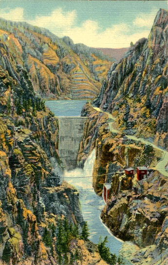
- The postcard images of the Buffalo Bill Dam and of Cody about 1940 are from the US Genweb Archives. Used with thanks.