The Rawlins to Baggs Wagon Road
The history of Wyoming is often about the ways people connect across our state’s wide spaces. Trade routes and trails from ancient times became emigrant routes, then wagon and stage roads and finally railroads and highways.
One of these, the Rawlins to Baggs Wagon Road was used to freight goods, mail, and passengers between Rawlins, Wyoming and points in southern Wyoming and northwest Colorado. The route was first known as the Rawlins to Snake River or the Rawlins to White River road, because the trail was originally used to transport goods and supplies to the Little Snake River valley and beyond that, to the Ute Indian White River Agency in northwestern Colorado.
There is a strong association between the trail and events leading to the Battle of Milk Creek in 1879, which resulted in the forced removal of the White River Ute tribe from Colorado to Utah. After the removal of the Utes, the government opened western Colorado to Euroamerican settlement. The trail became an important supply road to the new agricultural settlements of Routt and Moffat counties in Colorado, as well as the sparse settlements of southern Carbon County, Wyoming. The trail saw its greatest use between the arrival of the Union Pacific Railroad in Rawlins in 1868 and the completion of the Denver and Salt Lake Railroad to Craig, Colorado in 1913. Today much of the trail has fallen into disuse or has been covered by modern highways.

Location
The Rawlins to Baggs Stage Road in Wyoming followed the modern Twentymile Road (Carbon County Road No. 650N) southwest from Rawlins along the base of the west slope of the Atlantic Rim (See map). Approximately 30 miles south of Rawlins, the wagon road crossed Muddy Creek, a large tributary of the Little Snake River. Muddy Creek cut its way west through the Atlantic Rim in a narrow steep-sided canyon. This canyon was the route for the Overland Trail.

The Sulphur Spring Stage Station, an important stop on the Overland Trail was located at the west end of the canyon. The Sulphur Spring Stage Station closed in 1868 when stagecoach traffic ended on the Overland Trail due to the construction of the Union Pacific Railroad. The stage station was repurposed as a cattle and sheep ranch and became an important stop on the Rawlins to Baggs Road.
South of Sulphur Spring, the Rawlins to Baggs Road continued along the west side of Atlantic Rim, passing the JO Ranch, a historic sheep and cattle ranch the Bureau of Land Management now owns and has restored as a historic site. North of Baggs, the Rawlins to Baggs Road intersected modern State Highway 789 along the valley of Muddy Creek, by this time flowing south. The route of the Rawlins to Baggs Road follows Highway 789 to a crossing of the Little Snake River at Baggs, Wyoming. The trail continues through Colorado where it is known as the Baggs to Craig Road. The trail ran through Craig, Colorado and ended at the town of Meeker which was located within the old Ute White River Agency.
Early Development, 1830s to 1880s
The southern half of the Rawlins to Baggs Road along Muddy Creek was first developed in the 1830s as part of the fur trade. By that time pack trains were moving between competing fur trade posts along the South Platte River near modern Denver and the Hudson’s Bay Company post at Fort Hall, Idaho. In 1837, this traffic was enhanced by the building of Fort Davy Crockett, a fur-trade post on the Green River in Browns Park, northwestern Colorado. Travelers described crossing this area as early as 1839.
In 1841 a party of fur trappers and hunters led by Henry Fraeb, a partner of Jim Bridger, was attacked by Sioux, Cheyenne, and Arapaho warriors on Muddy Creek. Fraeb was subsequently killed along the Little Snake River near modern Dixon, Wyoming. In 1842, Fort Davy Crockett was abandoned due to Indian hostility. Other than explorer John C. Fremont, who crossed the area in 1844, there is little evidence of Euroamerican traffic through this region for the rest of the 1840s.
In 1850, with the California Gold Rush in full swing, the Cherokee Trail Southern Route followed the fur trapper route across the Atlantic Rim and crossed Muddy Creek. The Cherokee Trail did not originally follow the Rawlins to Baggs Road route, but crossed Muddy Creek and continued west. In 1854, the Holmes Variant of the Cherokee Trail, named after its founder Calvin Hall Holmes, left the Cherokee Trail Southern Route at Muddy Creek and followed the trapper route south to an intersection with the Little Snake River near modern Baggs. Cherokee Trail emigrants used this route through the 1850s and early 1860s. This marks the earliest wagon traffic along what would become the Rawlins to Baggs Road.
Portions of the Rawlins to Baggs Road were also used by emigrants traveling on the Overland Trail, a major east-west wagon road which was used by emigrants, freighters, and stagecoaches. The completion of the Union Pacific across Wyoming in 1868 ended stagecoach traffic on the Overland Trail, but emigrant wagon traffic continued well into the 1880s.
The Overland Trail in Wyoming was a difficult route for wagons due to the lack of good water, grass, and wood. During the 1860s, stage stations provided these necessities but when the railroad was completed, the stage stations closed. Without the stage stations, difficult stretches, such as along Bitter Creek, became even more difficult and emigrants had to adapt. Bypasses which avoided the route along Bitter Creek were developed in the 1870s. One of these detoured to the north, and ran between the Overland Trail at Sulphur Springs and Rawlins. This Overland Trail bypass used what became the Rawlins to Baggs Road.
Several Overland Trail diarists describe this route. Mary Riddle (1878) and a Mrs. Hampton (1888) traveled west along the railroad until they reached Rawlins. At Rawlins, they turned southwest on the Rawlins to Baggs Road, rejoining the Overland Trail at Sulphur Springs. Mary Riddle described the trip between Rawlins and Sulphur Springs on June 18, 1878. “We drove twenty-eight miles without stopping for dinner-it is enough to kill all the teams and people too this way. We crossed the summit of the Rocky mountains to-day—now we begin our downward course toward the Pacific slope. Camped at night by the grate (sic) Sulphur Springs. This little creek is called Mud Creek – the water is very bad. Oh dear, what I would give for a good drink out of the old pump at home – this is awful.”
From Sulphur Springs, Riddle turned west on the Overland Trail. No stage stations are mentioned on the Rawlins to Baggs Road until the abandoned Overland Trail stage stations on Muddy Creek were passed. Mrs. Hampton’s party followed the same route. She started a fire using poles from one of the abandoned stage stations, likely Washakie since Sulphur Springs was a ranch by 1888.
While Riddle and Hampton traveled south on the Rawlins to Baggs Road, Emily Towell (1881) and Viola Springer (1885) traveled north. These two parties followed the Overland Trail around Elk Mountain and crossed the North Platte River at the Overland Trail crossing. From Sulphur Springs, these parties traveled north to Rawlins on the Rawlins to Baggs Road, with the intention of continuing north along the Rawlins to Fort Washakie Road to join the Oregon Trail on the Sweetwater River. The descriptions of the trail between Muddy Creek and Rawlins are brief with little detail other than the general complaints of poor water and no forage.
Supplying the Utes, 1868-1882
Aside from fur trade and Cherokee Trail traffic, the earliest use of the Rawlins to Baggs Road began with the building of the Union Pacific Railroad across southern Wyoming in 1868. The completion of the railroad led to the development of settlements to the north and south, which could not exist without the railroad connection. The earliest use of the Rawlins to Baggs Road was to supply rural settlements south of the railroad.
The first phase focused on freighting supplies from the Union Pacific at Rawlins to the Ute White River Agency in Colorado. Western Colorado had been the homeland of various Ute bands for hundreds of years. In 1868, a reservation was established for the Utes in western Colorado. Within this reservation were two agencies, one on Las Pinos Creek in southwest Colorado and one along the White River in northwest Colorado. Lands in the White River Agency extended from the Continental Divide west to the Utah border and from the White River north to the Wyoming border. Euroamerican settlement was excluded from this area; annuity goods were promised to the Utes to compensate for the loss of hunting grounds. Government warehouses were built in Rawlins to store treaty-mandated annuity goods for Utes at the agency. Goods were freighted to the agency via the Rawlins to Baggs Wagon Road.
By the mid-1870s tensions were rising between the Utes and the Indian Agents assigned to the White River Agency. Promised annuity goods were often delayed, sometimes for months or even years, but the greatest tensions arose over the agents’ desires to convert the nomadic, horse-loving Utes to Euroamerican culture—particularly farming.
Matters came to a head in 1879 when newly appointed Indian Agent Nathan Meeker clashed with Ute leaders over the adoption of farming on the White River Agency. Meeker became fearful of the Utes and requested military aid. In September 1879, approximately 200 troops and civilians under the command of Major Thomas Thornburgh left Fort Fred Steele and marched south to the agency along the Rawlins to Baggs Road.
Thornburgh desired a peaceful resolution, but when his troops crossed Milk Creek the Utes interpreted this as an invasion of their land and attacked. Thornburgh was killed. Fighting continued from September 29 to October 5, 1879. Scout Joe Rankin rode the 170 miles from Milk Creek to Rawlins, supposedly in just 27 hours, to alert the army. A relief column marched south along the Rawlins to Baggs Road reaching the besieged troops on October 5. As a result of the Battle of Milk Creek, the White River Agency was closed in 1882 and all the Utes were removed from Colorado and resettled on a reservation in Utah.
Supplying settlers, 1882-1935
The removal of the Utes from western Colorado led to a second phase for the Rawlins to Baggs Wagon Road. Northwestern Colorado was now open to Euroamerican settlement. A few cattle ranches and stores had already appeared in northwest Colorado prior to the Ute removal. After 1882 new settlers flooded the area. Few large settlements were located along the Rawlins to Baggs or Baggs to Craig Wagon Roads. The town of Meeker, Colorado was built near the site of the White River Agency. Craig, Colorado was located where the Baggs to Craig Road crossed the Yampa River. Its principal period of development followed the arrival of the Denver and Salt Lake Railroad in 1913.
In Wyoming, the only significant town on the road south of Rawlins was Baggs. Baggs was the major distribution center for goods from Rawlins to ranches and settlements along the Little Snake River, including Savery and Dixon to the east, together with a group of ranches along the river valley west of Baggs known as the Darr Settlement. The Darr Settlement was named for its most prominent settler, John Darr, who arrived in the Little Snake valley in 1886. The Darr Settlement straddled the Wyoming/Colorado border and its residents had economic and social ties to both to Baggs and Craig.
One significant non-agricultural site was located along the trail in Colorado. This was the Craig-Baggs Gold Placer District, south of the Wyoming border along Four Mile Creek and Timberlake Creek. Gold was discovered there in 1891 and by 1892, some 4000 miners had arrived. Between 1902 and 1904, a floating bucket dredge was in operation with water brought in from Four Mile Creek and the Little Snake River via ditches. Small scale placer mining continued until the 1930s and included a dry land dredger. Local mining continues into the current century. The wagon road ran immediately east of the placer mining area.
Settlements along the Rawlins to Baggs Road in Wyoming were few because the area lacked a major river such as the Little Snake or Yampa. Only isolated ranches developed along the Wyoming section of the trail, primarily along Muddy Creek and its tributaries and springs. These ranches became the primary destination for goods and supplies freighted along the trail in Wyoming. They also became important way stations for freight and stage traffic on the trail.
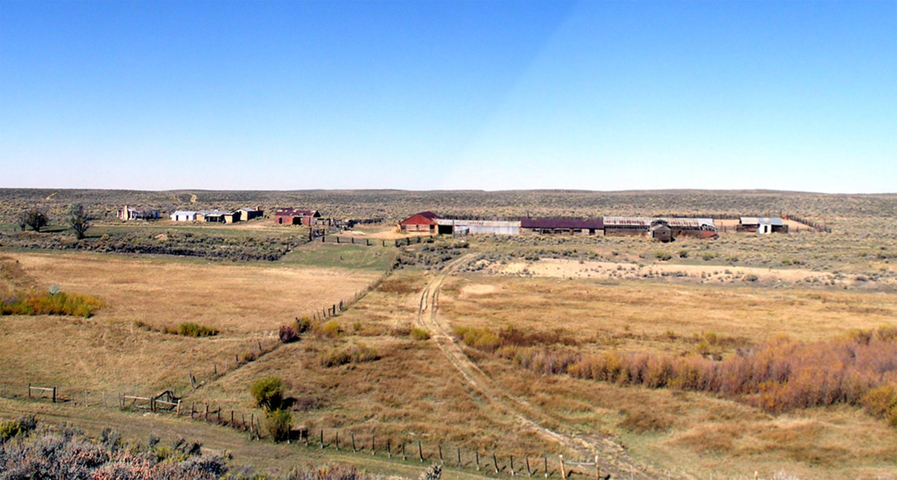
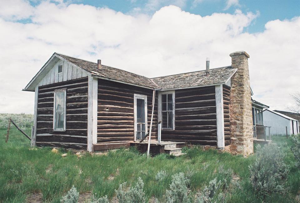
The Rawlins to Baggs Road did not develop formal stage stations like those found on the Oregon and Overland Trails. So-called road ranches fulfilled this need. Road ranches along the Wyoming section of the Rawlins to Baggs Road included, from north to south, the 16 Mile Station, the 20 Mile Station, Sulphur Springs, Willows Station, Perkins, and Muddy Bridge. At these stations, agriculture was the principal activity; support of freight and stage traffic was secondary. While not necessarily a road ranch, the J O Ranch was also a significant site on the wagon road.
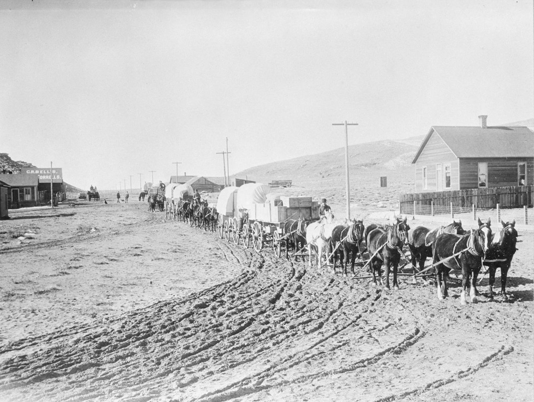
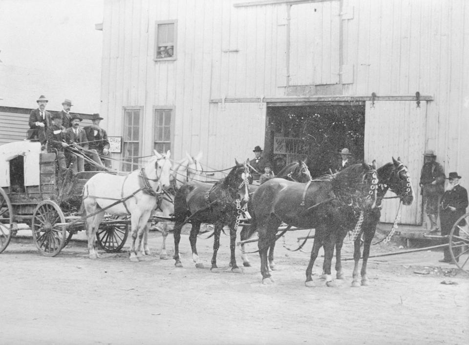
The J O Ranch was founded in 1885 by Joe Rankin, the scout who took word of the Milk Creek battle to Rawlins in September 1879—and returned with the Army relief column. In addition to ranching, Rankin and his brothers operated a livery stable in Rawlins, which was involved in freighting along the trail.
Freighters on the Rawlins to Baggs Road were a mix of professionals working for merchants like J. W. Hugus and local ranchers looking to supply their own needs or earn some extra income. Hugus owned a chain of stores in southern Wyoming, northern Colorado, and eastern Utah. His headquarters was first located at Fort Fred Steele and later in Rawlins from where he shipped goods to his other stores.
Lee Ratcliff, a Colorado rancher, described how freighters on the trail in the early twentieth century could haul moneymaking loads both directions. “On the way to Rawlins, there were way stations where food, lodging, and horse feed could be obtained for a price. One was the Davis ranch north of Craig; others were Baggs, and a place called the Willows. On this route, they would pick up a load of wool on the range and take it to Wamsutter [on the Union Pacific] where they received enough money for it to pay their entire expenses. This left what they were paid by J.W. Hugus for their freighting, clear profit. They often brought back as much as nine thousand pounds of freight for which they received a dollar a hundred [weight].”
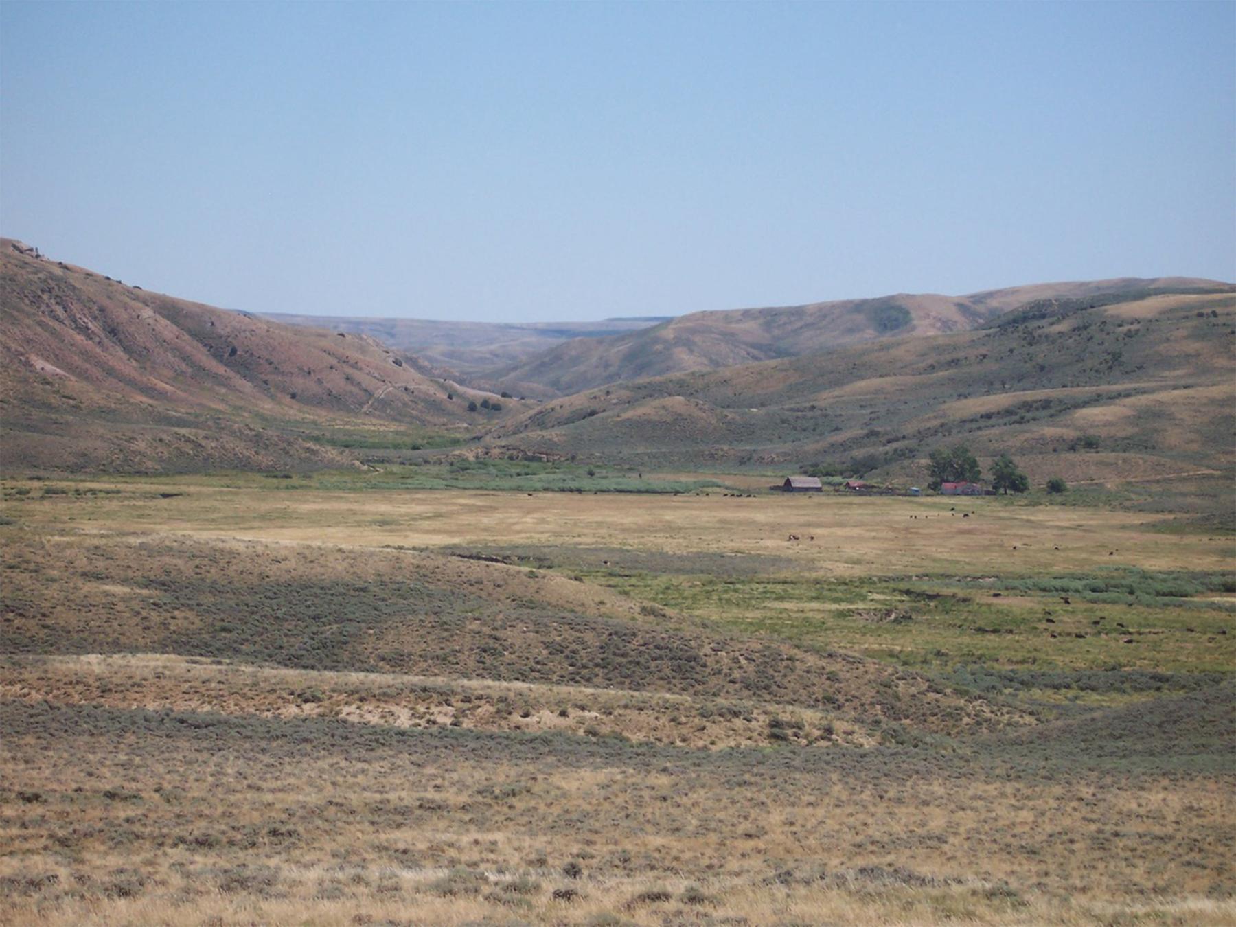
The arrival of the Denver and Salt Lake Railroad in Craig in 1913 began to lessen the need to freight goods and supplies from Rawlins, but this change did not occur immediately. The Colorado railroad used Rollins Pass at 11,660 ft to cross the Rockies. The pass was often blocked with snow in the winter. Cattle would frequently freeze in the railroad cattle cars. At the same time, the rural roads in Colorado were poorly built and maintained, resulting in bitter complaints by Moffat County residents, many of whom preferred to use the routes north to Rawlins and Rock Springs instead of the roads to Craig. Changes also occurred along the trail in Wyoming. Stagecoach operations ceased in 1909 and the road ranches returned to agriculture exclusively. Today, only the Sulphur Springs Ranch and the J O Ranch retain standing buildings. The J O Ranch is currently owned by the Bureau of Land Management and has been restored as a historic site. Sulphur Springs is still an active ranch. The other road ranches have been abandoned.
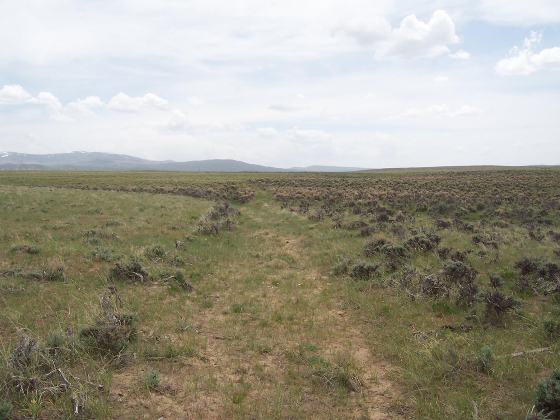
Portions of the Rawlins to Baggs Road began to be replaced by newer roads in the twentieth century. Between 1881 and 1910, the road described by Lee Ratcliff connected the Rawlins to Baggs Road with Wamsutter. This was a shorter and more direct route to the railroad but was used primarily as part of the seasonal movement of sheep and wool across the Red Desert. By 1935, the route of the Rawlins to Baggs Road was changed so that it intersected the Lincoln Highway, U.S. Route 30, at Creston Junction, 26 miles west of Rawlins. This route became modern State Highway 789. The Rawlins to Baggs Road has been largely abandoned or has been built over by the modern state highway.
[Editor’s note: Special thanks to Western Archeological Services, Inc., of Rock Springs, Wyoming, the author’s employer, and to the Wyoming Cultural Trust Fund, support from which in part made publication of this article possible.]
Resources
Sources
- Athearn, Frederic J. An Isolated Empire: A History of Northwest Colorado. Bureau of Land Management, Cultural Resource Series Number 2. Bureau of Land Management, Colorado State Office, Denver, 1981.
- Crofutt, George A. Crofutt’s Grip-Sack Guide of Colorado. The Overland Publishing Company, Omaha, Nebraska, 1885.
- Crofutt’s Transcontinental Tourist. George A Crofutt Publisher, 1874.
- Dirksen, Carolyn and A. Dudley Gardner eds. Oral History of Northwestern Colorado. Colorado Northwestern Community College, Craig Colorado, 1981.
- Erb, Louise Bruning, Ann Bruning Brown, and Gilberta Bruning Hughes. The Bridger Pass Overland Trail, 1862 – 1869. ERBGEM Publishing Company, Littleton Colorado, 1989.
- Fletcher, Jack E., and Patricia K. A. Fletcher. Cherokee Trail Diaries: Volume III, Emigrants, Gold Seekers, Cattle Drives, and Outlaws. The Fletcher Family Trust, Thomson-Shore Inc, Dexter Michigan. 2001
- Gardner, A. Dudley and David E. Johnson. Historic Overview of the Wagon Roads Located Along Section 1 of the Exxon Bairoil/Dakota CO2 Pipeline. Archaeological Services, Western Wyoming College, Rock Springs, Wyoming, 1987.
- Hafen, LeRoy R and Ann W. Hafen. To the Rockies and Oregon, 1839-1842. The Arthur H. Clark Company, Glendale California. 1955
- Hampton, Mrs. “Kansas to Oregon by Road and Rail,” in Covered Wagon Women: Diaries and Letters from the Western Trails, 1840-1890, Vol. XI, 1879-1903. pp 143-162. K. L. Holmes, ed., 1991.
- Johnson, David E. Class III Cultural Resource Inventory Report for the Anadarko Exploration and Production, Jolly Roger Delivery Pipeline, Carbon County, Wyoming. Western Archaeological Services, Rock Springs, Wyoming, 2005.
- Historical Assessment of the Cherokee Trail Segments Hangout Wash to Lower Powder Springs, Carbon and Sweetwater Counties, Wyoming. Western Archaeological Services, Rock Springs, Wyoming. 2011
- Class III Cultural Resource Inventory Report for the Dubois Telephone Down River Project Fiber Optic Line (Colorado) Moffat County, Colorado. Western Archaeological Services, Rock Springs, Wyoming, 2022.
- Johnson, David E. and Robert Rosenberg. Class III Cultural Resource Inventory for the Anadarko Exploration and Production Doty Mountain to Jolly Roger Lateral Pipeline, Carbon County, Wyoming. Western Archaeological Services, Rock Springs, Wyoming, 2005.
- Madsen, Brigham D. Exploring the Great Salt Lake: The Stansbury Expedition of 1849 to 1850. University of Utah Press, Salt Lake City. 1989
- Miller, Mark E. Hollow Victory: The White River Expedition of 1879 and the Battle of Milk Creek. University Press of Colorado, Boulder, 1997.
- Riddle, Mary. “Mary Riddle’s Diary, Coon Grove Iowa to Astoria, Oregon,” in Covered Wagon Women: Diaries and Letters from the Western Trails, 1840-1890, Vol. X, 1875-1883. pp 17-57. K. L. Holmes ed, 1991
- Rosenberg, Robert G. A Historical Assessment of the Rawlins to Baggs Wagon Road from Sulphur Springs Ranch to Baggs, Carbon County, Wyoming. Rosenberg Historical Consultants, Cheyenne, Wyoming.
- Springer, Viola. From Missouri to the Harney Valley, 1885. in Covered Wagon Women: Diaries and Letters from the Western Trails, 1840-1890, Vol. XI, 1879-1903. pp 73 - 139. K. L. Holmes ed, 1991
- Towell, Emily. Missouri to Idaho, 1881. in Covered Wagon Women: Diaries and Letters from the Western Trails, 1840-1890, Vol. X, 1875-1883. pp 197 - 219. K. L. Holmes ed, 1991
For further reading and research:
- Moulton, Candy. “BLM, volunteers work to preserve historic ranch.” Casper Star-Tribune, August 27, 2005, Accessed May 17, 2025 at https://trib.com/news/state-regional/blm-volunteers-work-to-preserve-historic-ranch/article_92179d5d-d8ac-5c30-b659-f250b0b26644.html.
- Van Pelt, Lori. “Joe Rankin,” in Dreamers & Schemers: Profiles from Carbon County, Wyoming’s Past. Glendo, Wyoming: High Plains Press, 1999, pp. 54-60.
Illustrations
- The photos in Rawlins of the Rankin livery stable and the freight wagons on Spruce Street are from the American Heritage Center at the University of Wyoming. Used with thanks.
- The two photos of the JO Ranch are from the Rawlins Field Office of the U.S. Bureau of Land Management. Used with thanks.
- The rest of the photos are from Western Archeological Services. Used with permission and thanks.