Crook County, Wyoming
The area that is now Crook County, Wyo. was once covered by a prehistoric ocean, as demonstrated by sea-plant imprints and shellfish and shark fossils found in the area. These fossils date back 110 million years to the Cretaceous Period. The water receded millions of years later, however, and just 13,000 years ago or so, people arrived—ancestors of today’s American Indians.
Petroglyphs dated from around 1,000 to 500 years ago show the presence of aboriginal people well before Europeans began settling in the area. Plains Indian tribes followed bison through the land and were largely unbothered by white settlers until 1811, when the Wilson Price Hunt Expedition passed through on a fur-trading venture bound for Oregon.
Long-simmering tensions between Indian tribes and white people erupted into war in the mid-1860s, when the U.S. Army built a string of forts to protect emigrants on the Bozeman Trail, bound from the Oregon Trail toward gold fields of Montana. This route came north through what soon became Wyoming Territory, east of where Crook County is now.
Cheyenne and Lakota Sioux warriors drove the Army away and burned the forts in what became known as Red Cloud’s War. The Treaty of Fort Laramie in 1868 set aside the area east of Dakota Territory and south of Montana—parts of the Black Hills and the Powder River Basin—as hunting grounds for the tribes.
The treaty prohibited white settlers from passing through the area without explicit permission from the tribes. In the 1870s, rumors of gold in the Black Hills began to spread. The government originally ordered the U.S. Army to keep prospectors out, but many slipped through. Those who were not caught and killed by Indians brought back stories, largely exaggerated, of huge gold deposits.
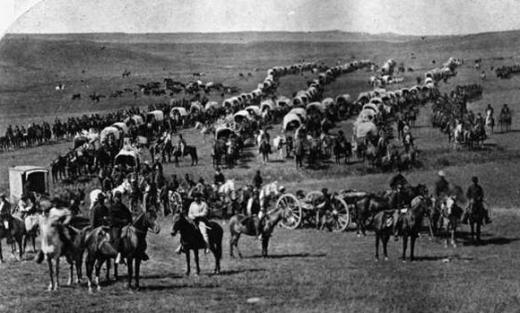
In 1874, the government sent a large military expedition under Lt. Col. George A. Custer to the Black Hills. He came back with reports that there was, in fact, gold there. A gold rush began, and pressure mounted on the tribes to sell their homelands.
Government officials met with Lakota Sioux chiefs in May and June 1875 to attempt to purchase the Black Hills, but the Indians balked. The land was holy ground for them, and they refused to part with it.
On Dec. 8, 1875, Wyoming’s territorial legislature created Pease (later Johnson) and Crook counties out of the northeast fourth of the territory. It was still Indian land, however. Just four days earlier, the Legislature showed its true intent in a memorial—that is, a message—to the U.S. Congress. The memorial referred to the Lakota Sioux as “the blood-seeking brave … and his filthy squaw,” and urged Congress to open the land “to settlement and improvement” so that Wyoming could “become what her natural resources entitle her to be … a great and prosperous state …”
The act only created the county on paper, however; it would be nearly 10 years before a county government was organized.
In early 1876, meanwhile, the government ordered the tribes out of the Powder River Basin and the Black Hills and onto reservations in Dakota Territory and Nebraska. The tribes, however, refused to go without a fight, and this led to the 1876 and 1877 campaign against the Sioux, including the fights on the Rosebud on June 17, 1876, Custer’s defeat on the Little Bighorn on June 25, 1876, and the attack on Dull Knife’s village of Cheyenne on the Red Fork of Powder River on Nov. 24, 1876. The war concluded with Indian surrender in 1877 and relocation to reservations. Brig. Gen. George Crook, the county’s namesake, directed these campaigns.
As early as late 1876, some brave settlers entered Crook County and began staking mining claims and launching small ranches. Cattle driven north from Texas began entering the area, and with them came more ranchers.
Beulah, now on Interstate 90 two miles east of the Wyoming-South Dakota line, is considered the first settlement in Crook County. First known as Sand Creek, the area drew gold prospectors in the late 1870s. The 1876 rush that began in Lead and Deadwood, Dakota Territory, extended west to Sand Creek, and while discoveries of the precious metal dwindled, the lush grass and plentiful water were enough to attract cattlemen to replace the gold-seekers who left.
Sundance, Wyo., was named after the adjacent Sundance Mountain, which was named in turn for the ritual ceremonies the Sioux performed on that sacred site. The town, founded in 1879, became the county seat when the county government was organized a few years later. A stage line connecting Spearfish, Dakota Territory and Sundance established a relay station at Beulah, and Beulah flourished, with a hotel, saloons and a dance hall.
By 1880, many large cattle operations were working the area and claimed all the land with direct access to Sand and Redwater creeks near Beulah. The 1880 census documented 239 residents in the on-paper Crook County, less than half of the 500 necessary to officially create a county.
Becoming a county
By mid-1884, the population had increased significantly. In October, the required 500 signatures appeared on a petition to organize a Crook County government. Territorial Gov. William Hale appointed W.F. Draper, J.S. Harper and W.H. Harlow as founding commissioners. They met in Sundance on Nov. 28, 1884, and set Dec. 9 as the date for the county’s voters to select a county seat and elect officers.
The commissioners met again on Jan. 22, 1885. Sundance was named the county seat. The county attorney and prosecutor, county clerk, probate judge, ex-officio justice of the peace and treasurer, sheriff, superintendent of schools, surveyor, assessor and coroner were administered oaths of office.
The second floor of a log building, rented for a monthly fee of $15 and moved to the center of town, was selected for the location of county offices. In its early years, the county’s commission work mostly involved roads, taxes and financial issues.
As the county grew, so did demand for better county offices. Early in 1886, the commissioners issued county bonds for $25,000 at 6 percent interest to pay for construction of a new courthouse and jail. They had no trouble raising the needed funds. In May, they accepted plans for the two new buildings. Construction began on Aug. 17, 1886. Winter weather and labor shortages delayed progress. Officers finally moved into the new building in December 1887.
Sundance made its way into the legends of the West after desperado Harry Longabaugh, then about 20, spent 18 months in the Sundance jail for horse theft beginning in 1887. Afterward, Longabaugh became known as the Sundance Kid. Longabaugh, his friend Robert Leroy Parker, a.k.a. Butch Cassidy and members of Cassidy’s Wild Bunch were responsible for a string of successful train and bank robberies between 1889 and 1901, when Longabaugh and Parker left the West for South America.
In 1890, the Wyoming Legislature created Weston County from the southern half of Crook County. Crook County was now bound by Johnson County on the west, South Dakota on the east, Montana on the north and Weston County on the south. In 1913, Campbell County was created, taking the western halves of Crook and Weston counties. Since then, the boundaries of Crook County have remained the same.
In 1906, Crook County won national attention when President Theodore Roosevelt declared Devils Tower, 25 miles northwest of Sundance, the nation’s first national monument.
Early industry
Crook County’s industrial past dates to the discovery in the 1870s of coal deposits about 20 miles northeast of Sundance, near what would become Aladdin, Wyo. Wagon teams originally transported coal 50 miles or more to gold smelters in Lead and Deadwood, Dakota Territory.
In 1895, the Black Hills Coal Company was founded and began mining coal in Crook County. Soon, the company needed a more efficient way than wagons to ship the coal. In 1898, the Black Hills Coal Company built the Wyoming and Missouri River Railroad to haul coal from the Aladdin area 18 miles to the east to the main Chicago and Northwestern Railroad line, at Belle Fourche, S.D. The new line also connected the mines to gold smelters in Lead and Deadwood, S.D.
The line between Aladdin and Belle Fourche operated from 1899 to 1927, but long before that the coal mines had begun to play out; coal transport was rare after 1910. Aladdin became a loading point for cattle bound for Omaha, Neb., markets.
After the turn of the last century, bentonite mining also became important in Weston and Crook counties. Demand for this clay mineral grew dramatically over the decades, as it came to be used in cement and plaster, cosmetics, insecticides and textiles.
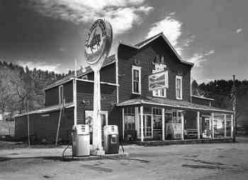
Colony, Wyoming’s northeasternmost community, was established April 7, 1908. There was never a town there – just a post office, store, telephone exchange and gas pump – but the Baroid Bentonite Plant was located in the area and later American Colloid Company (in the 1920s) and Archer-Daniels-Midland (in 1964) plants were built there.
Cattle, sheep and farming
Texas cattle had been coming into northeastern Wyoming since the late 1870s along the Texas Trail, which ran north along the eastern edge of the Territory and then turned northwest along a route followed in 1890 and 1891 by the Chicago, Burlington & Quincy Railroad. Once they reached the Wyoming end of the trail, some Texas cowboys from the trail herds stayed, settled in Crook County and went to work on large ranches; a few built thriving ranching operations of their own.
The Burlington crossed Crook and Weston counties through the new towns of Newcastle, Upton, and Moorcroft, a settlement 20 miles northwest of Upton. Moorcroft, in the southwest corner of what’s now Crook County, soon became a shipping hub for cattle. Before then, cattle in the northeastern ranges of the Territory were trailed to Rock Creek on the Union Pacific, in southern Wyoming, or after 1881 to Miles City, Montana for shipment to market. Now it was a much shorter trip for local herds to the Burlington Railroad at Moorcroft.
During the 1890s Moorcroft became the largest cattle-shipping point in the U.S., and remained an important shipping point until soon after the end of World War II.
Sheep followed the cattle industry to the area, and sheep significantly outnumbered cattle in Wyoming by the turn of the last century.
Over time, ranching and agriculture became the real successes for Crook County. With relatively mild winters and an average 24 inches of annual precipitation, the place was well suited for farming. Early day farmers cultivated wheat, oats, rye, corn, garden vegetables and small fruits for profit.
Current industry
Ranching and farming continue to be significant in the county economy. The oil and gas industry provides steady employment in Crook County, with Anadarko Petroleum Corporation, Merit Energy Company Co., Strata Energy Inc., Citation Oil and Gas Corp., T Roustabout, Flying J Oil & Gas, Rex A Brown Pumping Inc., Sterling Oil & Gas Company and True Oil LLC all operating here.
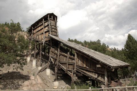
Coal mining has left its traces in Crook County, with abandoned mines in the area and some structures, like the remarkable coal tipple at Aladdin, remaining from the early days. Some county residents find employment in the coal mines near Gillette and Wright, Wyo., in Campbell County just to the west.
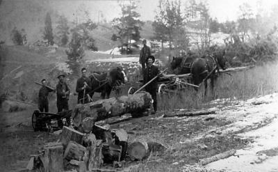
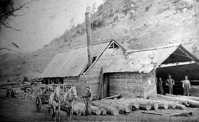
Logging has long been a big industry in Crook County. Neiman Sawmill Inc., founded in 1936 and using timber from U.S. Forest Service timber sales on the Black Hills National Forest, still operates in Hulett. In 2005, the county provided 58 percent of Wyoming’s timber, with more than 38,000,000 board feet produced.
Uranium was discovered in 1949, and the Homestake Mining Company opened north of Hulett to take advantage of this growing industry. The mine is still in operation.
County characteristics
Crook is Wyoming’s second smallest county in population.
The population soared between 1880, when 239 people were listed, and 1890, when there were 2,338. This dramatic increase was most likely caused by an influx of ranchers. The population continued to rise, but more slowly. By 1900, there were 3,137 people. By 1910, the number more than doubled and 6,492 residents were counted. Following that year, and for several decades, the population remained between 4,500 and 5,000 until 2000, when it jumped to 5,887, and 2010, growing to 7,083.
The lowest elevation in Wyoming, 3,125 feet above sea level, is located north of Aladdin where the Belle Fourche River flows into South Dakota.
Resources
- Bartlett, I.S. History of Wyoming. Chicago: The S.J. Clarke Publishing Company, 1918.
- Beard, Frances Birkhead. Wyoming, From Territorial Days to the Present, vol. 1. Chicago: American Historical Society Inc, 1933, 475-476, 544-546.
- Brandt, Jason P., Morgan, Todd A. and Thompson, Mike T. “Wyoming’s Forest Products Industry and Timber Harvest, 2005.” U.S. Department of Agriculture. Accessed July 23, 2012, at http://www.bber.umt.edu/pubs/forest/fidacs/WY2005.pdf.
- Crook County Historical Society. Pioneers of Crook County 1876-1920. Pierre, S.D.: State Publishing Company, 1981, 6-20, 39-40.
- Donahue, Jim, ed. Wyoming Blue Book. Vol. 5, part 1. “Administrative History of Crook County.” Cheyenne, Wyo.: Wyoming State Archives, 1991, 201-204.
- McFarland, Mel. “Wyoming’s First Coal Railroad.” Annals of Wyoming vol. 53 No. 1 (Spring 1981): 34-37. Accessed 10.3.12 at http://archive.org/stream/annalsofwyom53121981wyom#page/n35/mode/2up.
- “Texas Trail, 1866-1897.” UltimateWyoming.com, accessed Sept. 20, 2012 at http://www.ultimatewyoming.com/sectionpages/sec3/extras/texastrail.html.
- U.S. Bureau of the Census. “Historical Decennial Census Population for Wyoming Counties, Cities and Towns.” Accessed July 22, 2012, at http://eadiv.state.wy.us/demog_data/cntycity_hist.htm.
Illustrations
- The postcard of Sundance in 1902 is from the Crook County Museum and Art Gallery’s website. Used with thanks.
- William Illingworth’s photo of the 1874 Custer Expedition is from the National Archives, and is featured with many others from the same expedition on the website for the PBS production, The West.
- The photos of loggers and a sawmill near Hulett are from Wyoming Tales and Trails. Used with thanks.
- The 2005 photo of the Aladdin Tipple is by John Piepkorn, from Flickr. Used with thanks.
- The photo of the Aladdin store is from the Wyoming State Historic Preservation Office. Used with thanks.