The Lander Trail: National Road Building Comes to Wyoming
In 1857, with passage of the Pacific Wagon Road Act, Congress appropriated funds to survey and construct wagon roads. A segment of the first such national wagon road to be built in the West, now known as the Lander Trail, the Lander Road or Lander Cutoff, was named after the man in charge of its construction.
By the mid-nineteenth century, the U.S. government had a long history of helping create transportation infrastructure for the fledgling nation. However, the thousands of miles of emigrant trails that opened the vast expanses of the West had developed organically. The resulting spiderweb of cutoffs and supposed shortcuts created difficulties in the smooth flow of westward migration.
In 1846-1847, the ill-prepared Donner Party, for example, took bad advice from a commercially motivated, inaccurate guidebook and west of Fort Bridger in what’s now southwest Wyoming followed the Hastings Cutoff, named for the guidebook’s author. The result was starvation, death and cannibalism—an extreme example of the negative side of a transportation system based more on political and entrepreneurial whims than on sound engineering.
The military struggled to guard a road system that sprouted new routes as the author of the latest trail guide or some entrepreneur touted an easier, safer and shorter trip to given destinations. At the same time, each new route seemed likely to open new wounds with the original inhabitants of the plains, mountains and deserts, creating new difficulties for the government to manage. Something had to be done.
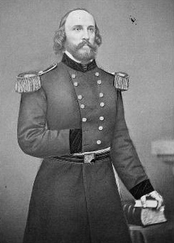
By 1857, Frederick William Lander was an accomplished railroad engineer and explorer. In those capacities, he had explored the foothills and passes of the Rocky Mountains, trailed the Souris River into Canada, trekked along the Columbia and Cowlitz rivers and mastered the passes of the Cascade Mountains. He was an able frontiersman and was reportedly rough on horses, with a hot temper and a reputation as a duelist.
Lander started as chief engineer on the proposed national wagon road, spending long days on horseback surveying potential routes. A few years earlier, he had scouted the South Pass of the Rockies in what’s now Wyoming as a potential railroad route. This experience made him an obvious choice to oversee construction of the new national road, with its planned route west of South Pass to City-of-Rocks in what’s now southeast Idaho.
He was not the first man to be selected as superintendent, however. That honor had gone to William Miller Finney Magraw. But in 1857, Magraw unexpectedly joined Albert Sidney Johnston’s expedition to re-establish federal authority in Utah Territory and to install federally appointed territorial officers. The move became known as the Utah War, and followed years of tension between the Mormons and the federal government over questions of sovereignty, polygamy, land rights, water rights and the authority of courts.
Lander was appointed in Magraw’s place in 1858. This replacement assured the national road was completed, because management of the project was transferred from a struggling drunkard to a highly competent and motivated captain. (Bad feeling continued between them, however. When the two superintendents met in Washington, D.C. in 1860, Magraw assaulted Lander with a blackjack, splitting open Lander’s head. Although severely injured, Lander beat Magraw nearly to death before being pulled away by several waiters.)
The national road, originally designated the Fort Kearney [sic], South Pass and Honey Lake Wagon Road, was designed to improve the extant California Trail system. Minor changes were made to the traditional California route on its eastern and western ends.
Significant modifications to the California Trail corridor were made starting in the South Pass area and going west to Fort Hall. The route between the trail’s final crossing of the Sweetwater River near South Pass and Fort Hall on the Snake River in what’s now southeastern Idaho, roughly 229 miles in length, is what came to be known as the Lander Trail. It was but a segment of a much longer road that stretched between Missouri and California.
Many believed that construction of the Lander Cutoff was intended to provide a route that avoided the Mormon settlements in Utah Territory. Following the ill-fated events at Mountain Meadows in September 1857, wherein California-bound emigrants of an Arkansas wagon train were murdered by Mormon militia, many travelers may have welcomed an alternate route.
However, many of the laborers Lander hired to build the new road were themselves Mormons from the Salt Lake Valley, making it seem unlikely the Army had any motives other than building a road that was safer because it was shorter.
Lander hired workers and laid out a route that made excellent use of terrain, available fodder, wood and water. His plan shortened the more traditional route from South Pass by way of Fort Bridger to Fort Hall by as much as 60 miles.
Lander’s road traversed some spectacular landscapes, with the snowcapped Wind River Mountains just to the north providing a stunning backdrop on the road’s eastern stretches. Despite Lander’s care in choosing the route, however, some emigrants noted difficult river crossings, such as the Buckskin Crossing of the Big Sandy. Lander’s route also ran through higher elevations for more of its length, thus making it more likely that travelers would encounter snow on the trail.
Most western wagon roads of the period were simply tracks worn into the ground by the passage of wagons and livestock. In contrast, much of the Lander Road was constructed. Lander’s workers moved roughly 62,000 cubic yards of earth and hewed trail through 11 miles of willow forests and 23 miles of pine forests. They built seven bridges, two corrals and, for safety, two blockhouses. Remarkably, the road was completed ahead of schedule and at a lower cost than expected. Lander also published, with government funds, an estimated 1,000 copies of a new trail guide advertising his route.
Before leaving his duties to return east, Lander assigned Charles Miller to supervise the new road from Gilbert’s Station at South Pass, but then withdrew the remainder of his men from the mountains. Miller did not survive the winter. He was murdered during an argument at the South Pass mail station.
Lander appointed Maj. Edmond Yates as Miller’s replacement. Yates persuaded large parties of emigrants to take the new road. Estimates of trail traffic are difficult to confirm, but the standard wisdom is that more than 100,000 people traveled on the Lander Trail. During peak years, such as 1859, the road may have been used by as many as 13,000 people, and during the Civil War, it became a favored option.
Overall, Lander’s placement of the road was well chosen. Always the perfectionist, Lander made slight modifications to avoid difficult segments of the trail, but found ways that allowed travelers to return to the planned route quickly. As with other wagon roads, Lander’s trail was altered by its users. They abandoned stretches that became unusable and created new variants.
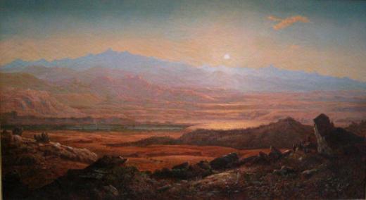
An unexpected benefit of the construction of the Lander Trail was Lander’s inclusion of artists Albert Bierstadt, Francis Seth Frost and Henry Hitchens on his team. These men produced works showing a romantic West that encouraged many to journey to the land where the sun sets.
Lander eventually became a national hero, seen by the public as an adventurer in the mold of John C. Fremont. When the Civil War broke out, he joined the Union Army. His artillery unit fired the first shots in the first land battle of the war, at Philippi in what’s now West Virginia.
In May 1861, the month after the war began, he reached the rank of brigadier general in the Army of the Potomac. The following October he was wounded in the leg, yet soon was given command of a full division on the upper Potomac. In February 1862, however, he succumbed to “congestive chills”—probably pneumonia—and, after two weeks during which his requests for relief went unheeded, died on March 2, 1862.
At the time of his death he was mourned by the nation; 40,000 people including President Abraham Lincoln, his cabinet, military brass, senators, congressmen, and the Supreme Court attended his funeral in Washington, D.C.
The Lander Trail is one of the few monuments to this remarkable man that survives today. Yet, perhaps his greatest contribution—the central route for the transcontinental railroad, which Lander had spent years scouting and championing and which became the route of the Union Pacific—does not bear his name.
Surviving portions of the Lander Trail are now designated by the National Park Service as part of the California National Historic Trail. Much of the trail and its variants are located on public land and are open to visitation. Markers have been placed to allow visitors to follow the trail route, although some segments are difficult to track. Where the original road passes through private and state lands, permission of the landowner or lessee is required before visitors can be allowed access.
Resources
- Cohen, Stan. The Civil War in West Virginia. Charleston: Quarrier Press, revised edition 1999.
- Ecelbarger, Gary L. Frederick W. Lander, The Great Natural American Soldier. Baton Rouge, La.: Louisiana State University Press, 2000.
- Franzwa, Gregory M. Maps of the California Trail. St. Louis, Mo.: Patrice Press, 1999, page numbers.
- Harstad, Peter, T. “The Lander Trail.” Idaho Yesterdays 12, no. 3 (Fall 1968): 14-28.
- Houston, Alan Fraser and Jourdan Moore Houston. “The 1859 Lander Expedition Revisited: ‘Worthy Relics’ Tell New Tales of a Wind River Wagon Road.” Montana: The Magazine of Western History 49, no. 2 (Summer 1999): 50-72.
For Further Reading
- Houston, Alan Fraser and Jourdan Moore Houston. The 1859 Lander Expedition Revisited: ‘Worthy Relics’ Tell New Tales of a Wind River Wagon Road. Montana The Magazine of Western History. Summer, 1999, 50-70, accessed 5/15/12. Good article that focuses extensively Lander’s patronage of and attitudes toward art and the painters Albert Bierstadt, Henry Hitchings and Francis Seth Frost, who accompanied the road-building expedition.
Illustrations
- The image of Frederick Lander is from Wikipedia.
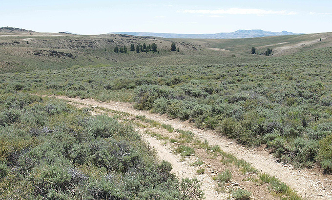
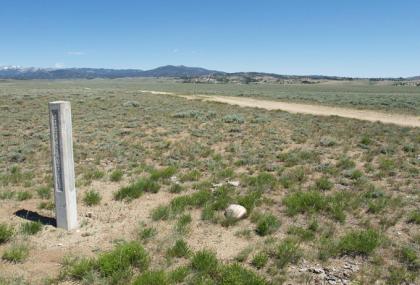
- The contemporary photos of the Lander Trail and the Lander Cutoff historical marker on Wyoming Highway 28 are by Will Bagley. Used with thanks.
- The brass caps mentioned in historical marker are no longer there. Collectors stole so many of the distinctive brass markers that the Bureau of Land Management pulled in the few remaining brass medallions from the concrete trail-marker posts in the first decade of the 21st century.
- Francis Seth Frost’s 1860 painting of South Pass and the Wind River Range is owned by the Smith College Museum of Art, accessed here through examiner.com and used with thanks.