Goshen County, Wyoming
Long before it was settled by white people, the territory in what’s now Goshen County, Wyo., was claimed by places as distant as Spain, France, Great Britain, Mexico and the Republic of Texas.
The Louisiana Purchase in 1803 established the claim of the United States to the area. Already by that time, fur trappers may have explored as far up the Platte and North Platte Rivers as Goshen County lies now. In 1813, Robert Stuart and a party of Astorians heading east to report back to American Fur Company owner John Jacob Astor were the first documented white men to camp in the area, near present-day Torrington, Wyo.
Early trails
In the 1820s, the route up the Platte and North Platte Rivers gradually became a thoroughfare for fur traders and trappers bound for the Rocky Mountains. In 1832, Capt. Benjamin Bonneville, on leave from the U.S. Army to try his hand at the fur business, brought a caravan of wagons through the valley. In the 1840s and 1850s the same route functioned as the road to Oregon, California and Utah, and by the late 1850s was the route of regularly scheduled stagecoaches carrying passengers and the U.S. mail.
The short-lived Pony Express, which carried mail from Missouri to California from April 1860 to November 1861, followed the same route, as did the transcontinental telegraph, completed in October 1861. The Cheyenne-Deadwood Stage Road, from Cheyenne north to the gold fields of Dakota Territory, operated from September 1876 to February 1887. Few people stayed very long—stopping only to rest a bit, wash clothes, and re-supply at Fort Laramie.
Travelers on all these trails left traces in Goshen County in the form of wagon ruts, place names and historic sites.
Fort Laramie
The first permanent settlement in the Goshen County area was Fort William, a trading post, built in 1834 near the junction of the Laramie and North Platte rivers. Fur traders Robert Campbell and William Sublette established and built the original wood stockade buildings, which became better known as the fort on the Laramie, or Fort Laramie.
After the original structures deteriorated, employees of the American Fur Company built a new adobe-walled post in 1841 and named it Fort John, though the post was still popularly called Fort Laramie. This fort was the major place for travelers heading west to replenish supplies, collect their mail and rest. In 1849, Fort Laramie was purchased by the United States government and operated as a military post through the peak years of the Indian wars on the northern plains. The fort was abandoned in 1890.
When Wyoming became a state in 1890, there were 12 counties, an increase from the original five, all of which had extended from the southern to the northern border of Wyoming Territory. The area that became Goshen County was originally part of Laramie County.
Goshen County was created officially when Gov. Joseph Carey signed the legislative act for its formation on Feb. 9, 1911, and the county’s government was organized in January 1913. Goshen County is a long rectangle, 72 miles long and 31 miles wide, with Laramie County on the south, Platte County on the west, and Niobrara County on the north. On the east, Goshen County borders the state of Nebraska. Torrington is the county seat.
What’s in a name?
There are several versions for the source of the name of Goshen. Some stories suggest that what’s now called Goshen Hole, a valley south of Torrington running northwest-southeast, parallel to the North Platte River, was originally named Goshé’s Hole after an early Indian warrior or French trapper.
Explorer John C. Fremont noted the place was named Goshen’s Hole when he camped there July 14, 1842. The fertile Land of Goshen, in Egypt, in the 45th chapter of Genesis in the Bible, has also been suggested as a possible source for the name. John Hunton, who was ranching in the area by the 1870s, was told by Seth Ward, post sutler at Fort Laramie, that the area was named for the biblical land. The name of Goshen Hole first appeared on a map years later, in 1888.
Early ranching
The same Seth Ward supposedly left a small herd of cattle out on the range during the winter of 1852-53, and, surprised they survived, continued the practice. At Fort Laramie, W. G. Bullock and B. B. Mills started the first permanent breeding herd and later moved south to Chugwater Creek.
After the Fort Laramie Treaty of 1868, the Sioux, Cheyenne and other tribes were restricted to hunting north of the North Platte River, and white people began moving cattle herds onto the plains north of Cheyenne and along Chugwater Creek and the Laramie River.
Pioneer ranchers in the area included John Hunton, Hiram B. Kelly, John Kessler, Charley Coffee and Philip J. Yoder. The Union Cattle Company and Swan Land and Cattle Company were the largest early ranches. While ranchers first settled mainly in what’s now the southern part of the county along Bear Creek, by the 1870s they had spread north of the North Platte River.
Goshen County continues to produce more cattle annually than any other Wyoming county. In 1997, Goshen County had 688 ranches and farms averaging 1,840 acres. By 2007 there were 665 farms in the county.
In 1900, the Burlington Railroad, building west up the North Platte River from Nebraska, entered Wyoming at Torrington and continued to Fort Laramie and Guernsey. Passenger service began in May. George King was the first station agent.
Torrington’s town site was surveyed April 21, 1900, and the land was sold to its residents for one dollar by the president of the Burlington’s land company. Torrington had been named by William G. Curtis for his Connecticut birthplace and his English ancestral home. He also established the first post office in his house in the new town.

Early irrigation
Developers of early irrigation projects hoped that the irrigation of dry land would draw settlers to the area. The first water right, dated 1881, was claimed from Rawhide Creek, north of the North Platte. Prior to this, however, settlers had already begun irrigating out of the North Platte River, Rawhide Creek and Horse Creek, which joins the North Platte near the Nebraska line.
The Reclamation Act of 1902 funded irrigation projects for the arid lands of 20 Western states. Revenue from sales of semi-arid public lands was to be used for the construction and maintenance of irrigation projects. The newly irrigated lands would then be sold and the revolving funds used to support more projects. In the Goshen County region, the North Platte River provided the water necessary for irrigation.
Two hundred fifty miles of the Interstate and Fort Laramie canals were constructed with about $10 million of Reclamation Service funding.
By 1947, the Fort Laramie canal, on the south side of the North Platte, provided water for the irrigation of 53,000 acres. People who used that canal formed the Goshen Irrigation District. Land on the north side of the North Platte River received water for 15,000 acres, and the Lingle Water Users Association and Hill Irrigation District operated this irrigation system. In the Hawk Springs area, the Horse Creek Conservation District drew water from that stream to irrigate 10,300 acres. Eventually, farmers and ranchers drilled wells for irrigation and to fill water tanks for livestock on the prairie pastures.
Towns and early settlers
The village of LaGrange on the banks of Horse Creek is the oldest in the county. Kale LaGrange was a driver for a stage route between Denver, Colorado Territory, and the Red Cloud and Spotted Tail Indian Agencies in northwestern Nebraska in 1867. In 1883, he claimed water rights from Horse Creek and is thought to have platted the town site in 1889. He also operated a mail route from Pine Bluffs, east of Cheyenne, to LaGrange.
Wyncote was established around 1900, as a section house on the Burlington line northwest of Torrington. Residents of the area were instrumental in building the Northside Ditch. But because the railroad was unable to obtain enough land there for a townsite, land to the east of Wyncote was donated instead for a new town. The Wyncote railroad section house was moved to the new site, and the town was named Lingle, for promoter and financier Hiram D. Lingle.
In the early 1920s, the Union Pacific railroad built a new line from Haig, Neb. to a point five miles west of Springer in Goshen Hole. The U.P. didn’t have a town site development company as the Burlington had, so towns along the line had to develop themselves. Railroads, irrigation canals and homesteading brought the towns of Huntley, Cottier, Yoder, Hawk Springs and Veteran into existence. The Burlington helped start Wyncote and then Lingle.
Goshen County grew fairly quickly in the 1920s, from 8,064 to 11,754, a growth of more than 45 percent, according to U.S. Census figures. Since then, the population has leveled off, growing slightly in some decades and shrinking in others, with its 2011 population estimated by the state of Wyoming at 13,536.
The depression years of the 1930s were possibly not as bad in Goshen County because its economy was stabilized by agriculture, and it lacked the boom-bust industries of mining and oil and gas that affected so much of the state.
The Jews of Huntley and Allen
The Jewish Agricultural Society, formed in 1900 by the Baron de Hirsch Fund to promote farming among Jews in the United States, sponsored about 50 families by establishing a new Zion community around what’s now Huntley, eight miles south of the North Platte and five miles east of the Nebraska line. The residents came from New York and Pennsylvania as well as from Europe.
On July 6, 1906, six men from the community filed claims for 160-acre homesteads located near present Huntley. They first built dugouts for dwellings. There were a number of challenges, however. The nearest water was about a half mile away in the Katzer Canal. Obtaining supplies was difficult as the closest general store was in Mitchell, Neb., about 15 miles east.
These settlers did not own horses, so they walked and carried flour, sugar, beans, rice and salt in knapsacks. They struggled at first, but after about a year, the Jewish Agricultural Society sent $500 to each family. With this money, horses, wagons, machinery, a cow and tools were purchased. Eventually, Huntley had a post office, church, grocery store and lumber yard.
In 1908, 40 or 45 more families, also supported by the Jewish Agriculture Society, moved to Wyoming and established a community called Allen, with a post office, a few miles northeast of Huntley.
A County seat
After the Legislature had authorized formation of Goshen County in 1911, citizens from both Torrington and Lingle began promoting their towns as the ideal county seat, with Lingle residents arguing that their town was more centrally located. Finally, Lincoln Land Company deeded a city block in Torrington over to the town for a courthouse site, and added a cash donation. Torrington citizens raised an additional $40,000, and the county commissioners awarded a construction contract.
On July 4, 1913, the three-story courthouse was dedicated and the cornerstone laid. Festivities included a parade, a county-wide picnic, an afternoon baseball game between teams from Torrington and Morrill, Neb., and in the evening, fireworks displays and two dances. Voters in 1980 passed a bond issue to expand the courthouse. The work was completed in 1984.
Jay Em
Jay Em’s beginning in the northern part of the county was also related to water. In the 1860s, Jim Moore claimed one of the last watering holes south of Lusk on the Texas Trail. He settled near the small drainage creek, and by 1869, Moore owned the second largest cattle ranch in Wyoming Territory. His brand, the J Rolling M, gave the name of Jay Em to the place. Moore died in 1875. Silas Harris and his three sons took over the ranch, calling it the Jay Em Cattle Company. One of the sons, Lake, filed a homestead claim on Rawhide Creek in 1912 and started the small town of Jay Em. During the 1920s and 1930s, the town was a center for commerce. There are a few residents in Jay Em today, and the town center is mostly vacant.

Yoder
Yoder was named for Jesse Yoder who headed the Goshen Townsite Development Company. He wanted to build a town beside the Union Pacific Railroad line, which passed several miles east of the Yoder ranch. His plan combined the two settlements of Springer and Lacy Corners. The town of Yoder soon boasted real estate offices and grocery, hardware and dry goods stores as well as a bakery and creamery. In 1922, a schoolhouse was added, and a newspaper started publishing weekly.
By 1925, more than 500 people lived in Yoder. By then, the town included three drugstores, two barber shops, a hotel, a bank, several churches, a doctor’s office, a community hall, a telephone office, rooming house and livery stable. Yoder, with its increasing commerce, seemed to be in competition with Torrington to become the business and trade center of the county. The growth spurt did not last, though. By 1970, the citizens numbered 101. The 2010 census placed the Yoder population at 151, with elementary, middle and high schools, a restaurant, bar and post office.
Veteran and Hawk Springs
After World War I, ex-servicemen were enticed to settle in the area by revisions of the homesteading laws. Each “veteran” and his family could qualify for an 80-acre irrigated farm to develop. The town of Veteran, established in 1920, earned its name from this program.
Hawk Springs, on Wyoming Highway 85 between Torrington and Cheyenne, was named because it was known as “the gentle spring where the falcon stood.” According to an article in The Torrington Telegram in 1946, Nelson H. “Nels” Sherard, one of the earliest settlers in the LaGrange area, said that the name came from a saloonkeeper at the springs now covered by Hawk Springs Reservoir whose name was “Black” Hawk.
Dry land farming continues today. Farmers grow wheat, dry beans, barley, corn, potatoes, hay, sunflowers and sugar beets. The Holly Sugar Company built a factory in Torrington, which began processing sugar beets on Oct. 10, 1926, one of five Holly sugar factories in the state. That year, the factory processed 21,000 tons of beets into sugar. In contrast, in 2012, the factory known as Western Sugar Cooperative, processed 745,000 tons of beets.

For decades, seasonal labor for thinning and topping the growing beets was done by migrant laborers. In the early years, many of the laborers were of Russian-German ethnic groups and, later, Mexicans and Mexican-Americans. These families came to the area in the early summer and left in late autumn when the work was finished. Today, the work is largely mechanized.
The dairy industry also helped Goshen County expand economically. Milk produced by local dairy cattle was used to make cheese, ice cream and butter.
By the early 1950s, Goshen County boasted thirteen grain and bean elevators, six potato docks, two creameries and five freezer-locker plants. Local farmers and ranchers produced more than $7.6 million in crops and livestock.
The Torrington Livestock Commission is the largest livestock auction barn in the area and continues to have regular Wednesday and Friday auctions. As of 2011, Goshen County ranks number one in Wyoming for its cattle inventory.

Today, most of Goshen County’s 13,000-plus people live in Torrington. Agriculture is still a predominant livelihood as are education and government occupations. There are three high schools: Torrington; Lingle-Fort Laramie in Lingle; and Southeast in Yoder.
Eastern Wyoming College, a two-year degree institution, is located in Torrington. Granger is home to the unaccredited Frontier Bible College, which offers three-year associates degrees in Bible studies.
Two groups—the Goshen County Economic Development Corporation and the Goshen Chamber of Commerce--promote economic development and community enhancement.
There are seven banks, 21 churches, and a number of civic clubs including Rotary International, the Elks Club, the Moose Family Center, the Lions Club, and an active 4-H organization. American Legion Travis Post No. 5 is also located in Torrington. Many citizens are also involved with the Goshen Community Theater.
The Torrington Senior Friendship Center with its branches offers meals and programs to entertain and enlighten senior citizens. The Banner Health System offers a hospital, clinic, and various therapies in the area.
For recreation there are municipal parks, visits to the historic trails and Fort Laramie National Historic Site, and water sports at Hawk Springs reservoir, Springer reservoir and on the North Platte River. The county hosts the Two-Shot Goose Hunt, which brings people to the popular hunt and art show every December.
Resources
Primary Sources
- Fremont, John C. Report of the Exploring Expedition to the Rocky Mountains in the Year 1842, and to Oregon and North California in the years 1843-'44. Washington: Gales and Seaton Printers, 1845, pp. 34-35. Accessed Dec. 31, 2012 at http://books.google.com/books?id=W8ICAAAAMAAJ&pg=PA9&source=gbs_toc_r&cad=4#v=onepage&q&f=false
Secondary Sources
- Department of Administration and Information. Equality State Almanac, 12th Edition, Cheyenne: 2008.
- Goshen County History Book Committee. Wind Pudding and Rabbit Tracks, Vol. 1. Torrington, Wyo.: Platte Valley Printers 1989.
- _________________________________. Wind Pudding and Rabbit Tracks, Vol. 2. Torrington, Wyo.: Platte Valley Printers, 1993.
- “Goshen Hole,” Wyoming Places website, accessed Jan. 30, 2013 at http://wyld.sdp.sirsi.net/maps/index.html?q=Goshen%20Hole
- Hamon, John, B. H. Trierweiler and George Knutson. Goshen County, Wyoming In the Famous Goshen Hole. Torrington, Wyoming: Board of Goshen County Commissioners, 1947.
- “The History of Goshen County.” Goshen County, One Part of the Wyoming GenWeb. Accessed Dec. 31, 2012 at http://www.hometownchronicles.com/wy/goshen/goshenhist.htm.
- Hodgson, Don. History of Goshen County. Eastern Wyoming College, Torrington, Wyo.: 1980.
- ____________. The Search for Community in Goshen Hole. Eastern Wyoming College, Torrington, Wyo.: 1982-1983.
- Johnson, Elizabeth Wilkinson, Editor. Trails, Rails and Travails. City of LaGrange, LaGrange, Wyo.: 1988.
- U.S. Census Bureau. “Historical Decennial Census Population for Wyoming Counties, Cities and Towns. Wyoming Division of Economic Analysis, accessed Jan. 31, 2013 at http://eadiv.state.wy.us/demog_data/cntycity_hist.htm.
- Wyoming 2011 Agricultural Statistics, United States Department of Agriculture, Todd Ballard, Director.
- Zimmer, Vickie. Goshen County. Charleston, S.C. : Arcadia Publishing, 2012.
Illustrations
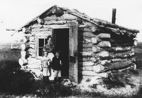
- The photo of the Powers family homestead is from the collections of the Homesteaders Museum in Torrington. Annie Chamberlain served as postmistress at Lingle. Her husband, Tom Powers, was the first state senator from Goshen County. Used with thanks.
- The photo of the men ditching an alfalfa field on Hiram Lingle’s Valley View Ranch near Lingle, 1912, negative 3387 at the Wyoming State Archives, is by the great Union Pacific photographer J.E. Stimson. Accessed here via a digital collection of Stimson photos prepared by the Wyoming State Historic Preservation Office. Used with thanks.
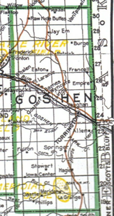
- The early map of Goshen County, around 1915, is from the Homesteaders Museum in Torrington. Used with thanks.
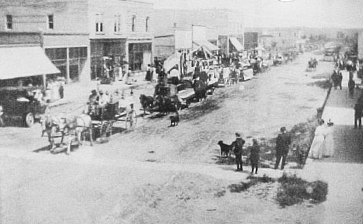
- The photo of the Goshen County fair parade, 1919, is from the Homesteaders Museum in Torrington. Used with thanks.
- The Torrington Telegram advertisement for the town of Yoder is from Wyoming Places. Used with thanks.
- The photo of the Holly Sugar factory in Torrington is from the Homesteaders Museum. The factory was built in 1926 and had its own Union Pacific Railroad spur. Used with thanks.
- The photo of Weimer and Maxene Denney with their load of beets from the Knowlton farm is from the Homesteaders Museum in Torrington. The beets were taken to a local beet dump for weighing, before being transferred to the Holly Sugar factory in Torrington. Used with thanks.