South Pass
Without South Pass, the entire history of the United States’ expansion west of the Mississippi would have been different. South Pass got its name to distinguish it from the tedious and difficult northern route through the Rocky Mountains taken in 1805 and 1806 by Lewis and Clark through the Bitterroot Mountains.
As any aficionado of the Corps of Discovery knows, the Bitterroots nearly destroyed the dreams of that expedition. By the time the Corps stumbled out of the mountains, they were frozen and near death from starvation. Even today, few roads cross the Bitterroots, and the country between the great Missouri River and the mighty Columbia remains as topographically complicated as it was when Lewis and Clark crossed it.
Thus, the discovery of a direct land route across the Continental Divide with a relatively easy grade was a godsend to those who hoped to see the United States of America stretch from the Atlantic to the Pacific. Without South Pass, it is almost certain that the Pacific Northwest would have been permanently claimed by the British and the southern part of the continent would have remained part of Mexico. South Pass, the isolated little saddle that straddles the Continental Divide in the midst of Wyoming, still the least populated state in the nation, truly provided the key to today's United States.
While the pass had been used by American Indians for millennia, the first known usage by white men occurred in 1812 when Robert Stuart and six companions crossed the mountains on their return to the East from Astoria at the mouth of the Columbia, on the Oregon coast. In 1832, Capt. Benjamin Bonneville and a caravan of 110 men and 20 wagons became the first group to take wagons over the pass.
Then, on July 3, 1836, missionary Marcus Whitman crossed the pass with his wife, Narcissa, and their missionary companions, Henry Spalding and Eliza Hart Spalding. Narcissa Whitman and Eliza Hart Spalding became the first white women to cross the Continental Divide at South Pass.
This tiny trickle of white people would become a stream in the 1840s and a river in the 1850s and 1860s. Between 1841, when the first Oregon-bound wagon train was organized, and 1869 when the transcontinental railroad was completed, somewhere between 350,000 and 500,000 emigrants crossed South Pass on the trails bound for Oregon, California or Utah’s valley of the Great Salt Lake. Their multiple routes converged to form a common trail corridor near Fort Kearny in what’s now central Nebraska before parting again beyond Dry Sandy, a short way west of South Pass.
As the years went by, commercial freight traffic, bound east as well as west, became steadily more common on the route across South Pass. The 1850s saw stagecoaches carrying passengers and mail offering first monthly, then weekly and finally daily service.
The Pony Express was established in the spring of 1860, and at its inception could carry a letter from St. Joseph, Missouri via South Pass to Sacramento, California in just two weeks. Construction of a transcontinental telegraph line began about the same time along the same route; by the fall of 1861 the line was finished and the Pony Express disbanded.
After 1862, much of the commercial traffic moved south to the Overland Trail, which crossed what’s now southern Wyoming by a more direct route, most of which later became the route of the Union Pacific Railroad and Interstate 80. The telegraph continued to follow the South Pass route until the late 1860s, when it was moved south to the railroad line.
For westbound travelers, the push to the South Pass crossing started at Independence Rock, where their slow, steady climb over the Continental Divide began. Many didn't even realize the backbone of the Rockies had been conquered until they reached Pacific Springs west of the pass, so gradual was the incline.
And the exact elevation of that backbone has been disputed throughout modern times. Today, it is fairly well established that the crest of South Pass is situated on the Continental Divide in Fremont County, Wyo., about 10 miles southwest of South Pass City, at 42 degrees 21 minutes north latitude and 108 degrees 53 minutes west longitude, at an elevation of 7,440 feet above sea level, or 2,267.712 meters.
Until recently, however, there was a surprising amount of confusion about the elevation. The noted historian, Dale L. Morgan, gave its elevation as 7,550 feet above sea level, a figure that has often been cited though it actually reflects the elevation of the Continental Divide to the north of the pass. The U.S. Geological Survey’s Pacific Springs 7.5 minute quadrangle gives the elevation as 7,412 feet, as do many other reference works.
During a June 2006 field survey, Colleen Sievers of the U.S. Bureau of Land Management’s Rock Springs office took a Global Positioning System reading at the Meeker and Whitman monuments, normally considered to be "the summit," that produced a reading of 7,440 feet above average mean sea level, with an error factor of plus or minus three feet.
Trail expert Paul Henderson wrote of the Meeker marker, "This monument stands twenty feet west of the actual culminating height of the Pass where the old trail crossed the divide line," but did not explain how he determined that location. According to another well-known trail expert, Gregory Franzwa, the U.S. Geological Survey engineers surveying the Continental Divide in 1946 determined that Ezra Meeker--the pioneer promoter of preserving Oregon Trail history— missed "the precise location of the divide . . . by less than fifty feet."
Today, most people view the pass from the BLM's roadside exhibit, situated just off state Route 28. From there, it is possible to follow the old trail ruts next to the exhibit parking area to the actual summit which you will know you have reached, even without a GPS unit, by the two markers you will find there.
In 2014, the Lander Field Office of the BLM issued its Resource Management Plan covering its part of South Pass. The RMP limits rights of way to designated corridors, oil and gas development, and mining. It closes the area to phosphate mining, wind energy development, and limits sand and gravel quarries to spots not visible from the trails. It protects the existing character of the landscape and will keep future impacts low.
At South Pass, visitors can still imagine themselves as fur trappers, trailblazers, missionaries or emigrants bound for Oregon, forty-niners eager for California gold or recently converted Mormons, just arrived from Scandinavia.
The West opens up for anyone who stands on South Pass.
Resources
Primary Sources
- Duffin, Dorothy B. “The Whitman-Spalding Marker at South Pass.” Overland Journal 18 no. 1 (Spring 2000):
- Franzwa, Gregory M. The Oregon Trail Revisited, 5th ed. St. Louis, Mo: The Patrice Press, 1997.
- ------. Maps of the Oregon Trail, 3rd ed. St. Louis, Mo: The Patrice Press, 1990.
- Guenther, Todd, Erin Hammer, and Fred Chaney. “The Women Who Carried the Star of Empire Westward: Eliza Spalding & Narcissa Whitman.” Overland Journal 20, no. 4 (Winter 2002): 130–51.
- Irving, Washington. The Rocky Mountains: or Scenes, Incidents, and Adventures in the Far West; digested from the Journal of Capt. B. L. E. Bonneville, of the Army of the United States, and illustrated from various sources. 2 vols. Philadelphia, Penn: Carey, Lea, & Blanchard, 1837. Reprinted as The Adventures of Captain Bonneville, U.S.A. Edited by Edgeley W. Todd. Norman, Okla.: University of Oklahoma Press, 1961. Republished as The Adventures of Captain Bonneville. Washington, d. c.: National Geographic Adventure Classics, 2003. Accessed Jan. 31, 2006, at http://www.xmission.com/~drudy/mtman/html/bville/bvilleint.html.
- Morgan, Dale L. Overland in 1846: Diaries and Letters of the California-Oregon Trail, 2 vols. Georgetown, Calif.: The Talisman Press, 1963, University of Nebraska Press, 1993.
- Spalding, Eliza Hart. “Diary of Mrs. H. H. Spalding.” In Memoirs of the West: The Spaldings. Edited by Eliza Spalding Warren. Portland Ore.: Press of the Marsh Printing Company, 1916. Republished in First White Women Over the Rockies: Diaries, Letters, and Biographical Sketches of the Six Women of the Oregon Mission Who Made the Overland Journey in 1836 and 1838. Edited by Clifford M. Drury. Glendale, Calif.: Arthur H. Clark Co., 1963, 1:173–233.
- Spalding, Henry H. “A Letter by Henry H. Spalding from the Rocky Mountains, 11 to 16 July 1836.” The New York Evangelist, Oct. 22, 1836. Reprinted in Oregon Historical Quarterly 51 (1950), 127–33. Accessed April 24, 2006, at http://www.xmission.com/~drudy/mtman/html/spalding.html.
- Stuart, Robert. The Discovery of the Oregon Trail: Robert Stuart’s Narratives of His Overland Trip Eastward from Astoria in 1812–13. From the original manuscripts in the collection of William Robertson Coe, esq., to which is added: An account of the Tonquin’s voyage and of events at Fort Astoria and Wilson Price Hunt’s diary of his overland trip westward to Astoria in 1811–12. Translated from Nouvelles annales des voyages, Paris, 1821. Ed. by Philip Ashton Rollins. New York, N.Y: Eberstadt & Sons, 1935. Paperback edition, Lincoln, Nebr: University of Nebraska Press, 1995.
Secondary Sources
- Rea, Tom. Devil’s Gate: Owning the Land, Owning the Story. Norman: University of Oklahoma Press, 2006, 102-103.
- Stuart, Robert. On the Oregon Trail: Robert Stuart’s Journey of Discovery. Edited by Kenneth A. Spaulding. Norman, Okla.: University of Oklahoma Press, 1953.
For Further Reading
- Wyoming State Historic Preservation Office. “South Pass National Historic Landmark,” accessed 5/21/20 at South Pass National Historic Landmark.
- Photographs of both the Meeker and Whitman markers at South Pass and a short article by Will Bagley about the history of the markers can be viewed online at the Alliance for Wyoming History website at http://www.historicwyoming.org/index.php?id=308.
Field Trips
For a free, handy guidebook to the trails across Wyoming, complete with historic background, modern color photos and a good, fold-out map, order a copy of “National Historic Trails Auto Tour Route Interpretive Guide Across Wyoming,” from the National Park Service, National Trails System—Intermountain Region, 324 South State Street, Suite 200, Box 30, Salt Lake City, Utah, 801-741-1012, email ntsl_interpretation@nps.gov. See also the Park Service’s websites for the Oregon, Pony Express, California and Mormon Pioneer trails at www.nps.gov/oreg, www.nps.gov/poex, www.nps.gov/cali and www.nps.gov/mopi.
For still more information on historic trails across Wyoming and the West, visit the websites of the Oregon-California Trails Association and the Alliance for Historic Wyoming.
Illustrations
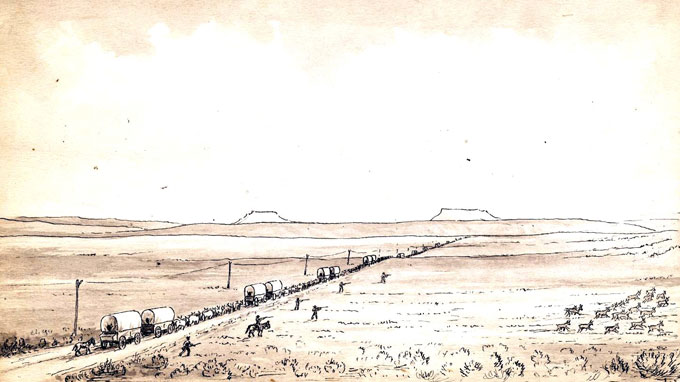
- Pioneer photographer William Henry Jackson based this sketch of wagons and the transcontinental telegraph line near South Pass, with the Oregon Buttes in the distance, on his experiences in 1866, when he first crossed the pass as bullwhacker for a freight outfit at the age of 23. The men to the right of the wagon train are shooting at the fleeing pronghorn antelope. From the William Henry Jackson Collection at Scotts Bluff National Monument. Used with thanks.
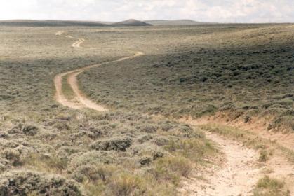
- The photo of the Oregon Trail between South Pass and Pacific Springs is by Terry Del Bene. Used with thanks.
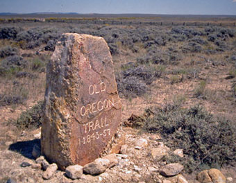
- The Oregon Trail monument at South Pass was erected in 1906 by early trail booster Ezra Meeker. Photo by Randy Wagner, used with thanks.
- In the photo gallery, the view across South Pass toward the Wind River Mountains from the top of Pacific Butte is by Barbara Dobos. Used with permission and thanks. The rest of the photos are by Tom Rea.
Author
WyoHistory.org thanks the Alliance for Historic Wyoming, which published an earlier version of this article.