Campbell County, Wyoming
Campbell County, in northeastern Wyoming, is part of the Powder River Basin, which stretches from the crest of the Bighorn Mountains to the western Black Hills. A perfect habitat for the North American bison and other large mammals, for generations the region was a valued hunting ground for American Indians, especially the Lakota Sioux.
The rectangle of present-day Campbell County, approximately 4,761 square miles, is mostly grassland over extensive sub-bituminous coal deposits dating from the Cretaceous and Tertiary Periods. Some of the coal deposits in the Powder River Basin are so close to the surface that early settlers could dig their own coal.
Campbell County’s coal is low in sulfur compared to coal mined in the eastern United States. Since 1990, when the Clean Air Act was amended to require electric utilities to reduce sulfur emissions from their coal-fired power plants, Campbell County’s low-sulfur coal has enjoyed distinct advantages in the national market—despite the long distances the coal is often shipped to utilities in the Midwest and South.
Campbell County is bordered on the south by the counties of Converse and Niobrara; on the east by Weston and Crook; on the west by Johnson and Sheridan; and on the north by the state of Montana. Although the Powder River flows through only the far northwest corner of Campbell County, the river’s south-to-north course roughly parallels the western border of the county, just across the Johnson and Sheridan County lines.
Ancient Times and Early Explorers
Ancient deposits of bison bone establishing the presence of Paleo-Indians have been found at various points in Campbell County. The Ruby Site near Pumpkin Buttes in the southwest corner of the county is one of the best known. It is a bison pound—an ingenious structure similar in design to a modern-day cattle corral, though likely much stronger. It was probably used by the Besant hunters around A.D. 100 or shortly afterward.
An older site from perhaps 10,000 years ago is the Carter/Kerr-McGee site north of Gillette, Wyo., excavated in 1975 before the opening of the Carter/Kerr-McGee coal mine. There, a bison butchering area was found and, nearby, an arroyo that probably formed a natural trap into which the animals could be driven. This site indicated the presence of the Goshen, Folsom, Agate Basin, Hell Gap, and Alberta-Cody cultures. Prehistoric cultures are generally named for the places where artifacts identifying them were first found.
The first American explorer-trapper to travel through the area that is now Campbell County was probably Francois-Antoine Larocque in 1805, trading with the Crow Indians on behalf of the Montreal-based North West Company. John Colter visited the area in 1807-1808, followed in 1811 by Wilson Price Hunt and a party of men sent by fur-trade tycoon John Jacob Astor. This group, the "overland Astorians," crossed the basin on their way to the Columbia River drainage.
Then, in 1828, Robert Campbell and a party of men from the Rocky Mountain Fur Company traveled through, trapping for beaver along Powder River. The peripatetic missionary Father Pierre-Jean DeSmet passed by the Pumpkin Buttes in 1851, and referred to them in a diary entry as the "Gourd Buttes."
The Bozeman Trail, a route from the Oregon Trail along the North Platte River to newly discovered gold fields in Montana Territory, passed through the southwest corner of what’s now Campbell County. It was traveled by prospectors and settlers starting in 1864. Attacks by the Cheyenne, Lakota Sioux and Arapaho were common, earning the trail its nickname, the Bloody Bozeman.
To protect the white travelers, the U.S. Army was ordered to patrol the trail, and for four years there were many fights and skirmishes in what came to be called Red Cloud’s War. In the Fort Laramie Treaty of 1868, the Powder River Basin was relegated to the Sioux, Cheyenne and Arapaho. Only eight years later, on Jan. 31, 1876, the U.S. government proclaimed that all the Indians must move to reservations. More warfare followed. By 1878, the area was open to white people.
Early settlement and cattle ranching
The earliest cattle drive from Texas to Montana passed through northeast Wyoming in 1866. In the late 1870s, cattle ranches began to be established, and with the end of the Indian threats, white settlement began in earnest. Although the winter of 1886-1887 destroyed many large herds and ended the open range era, some cattle ranching continued. Ranchers began to grow their own hay for cattle feed or sometimes shipped herds to out-of-state winter feeding locations.
County boundaries and organization
The area that would eventually become Campbell County began as part of Albany County, Wyoming Territory in 1869. In 1875, the territorial legislature created Crook County out of the northern halves of Albany and Laramie Counties; Crook County took up the entire northeast corner of the territory. Future Campbell County would occupy the western half of this area. First, however, in 1890, Weston County was created from the southern half of Crook County, with a boundary stretching from the Nebraska state line to Johnson County.
Finally, with the creation of Campbell County by an act of the state legislature on Feb. 13, 1911, and the organization of its government on Jan. 6, 1913, the western halves of Crook and Weston counties were sliced by a north-south line running from the Montana state line to the Converse County border. (Converse County had been formed in 1888 out of other parts of the original Albany and Laramie counties.)
There is some dispute about who the county was named for--either Robert Campbell, the early fur trader mentioned above, or John A. Campbell, the first territorial governor of Wyoming. According to the Wyoming Blue Book, some sources "probably trying to make peace, claim Campbell County was named for both men."
The railroad and small towns
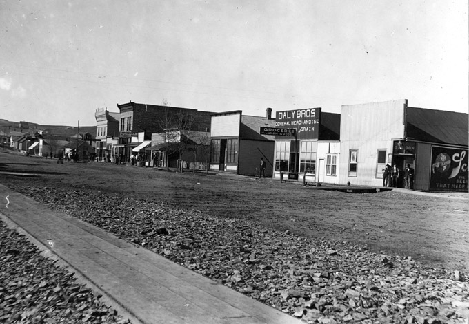
In August 1891, the Chicago, Burlington and Quincy Railroad's subsidiary, the Burlington and Missouri River Railroad, reached Gillette, creating a more convenient shipping point for cattle ranchers in the area. Prior to that time, herds had to be trailed hundreds of miles to be shipped to market.
For approximately one year, Gillette was the terminus, and with the presence of the railroad commissary, this created a small, short-lived boom that ended when the tracks reached Sheridan in November 1892. Still, the railroad brought an influx of settlers—farmers, ranchers and townspeople.
Gillette was incorporated that same year. After the railroad terminus moved on, Gillette settled into a typical small-town rural economy with livery barns, stables, blacksmiths, hotels, cafes, bars and brothels.
The earliest surviving edition of the Gillette News, which began publication in 1891, is dated Jan. 14, 1892, showing J.S. Taylor as editor. Page two of this issue featured advertisements for the Hotel Empire, Windsor Hotel and the Miller House. The latter boasted, "Excellent Accommodations for Transient Patronage." The Stafford Restaurant claimed that fresh oysters were always on hand.
The first school had been built in 1891, but the first bank, the Bank of Gillette, was not opened until 1902. A full telephone exchange was established in 1910. Five years later, electricity was supplied. When Campbell County’s government was organized in 1913, Gillette became the county seat.
On May 4, 1934, Camp Miller, a Civilian Conservation Corps camp, was established near Gillette. The primary work for these 100 or so men was to fight the underground coal fires that had been destroying veins for some years. Some of these fires weakened the surface above them, creating unseen dangers for people and animals. In 1941, with the start of World War II, the camp was abandoned.
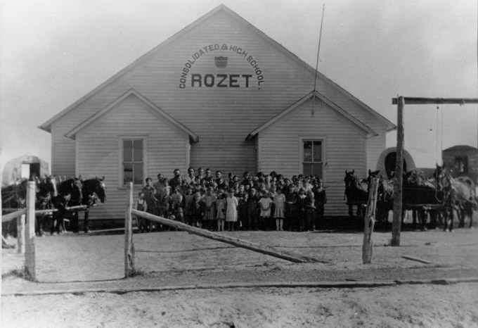
Campbell County’s population, meanwhile, had reached 6,720 residents in the 1930 census. At least 23 small towns had appeared in the county in the decades after the railroad arrived. A handful of these remain, mostly hamlets: Spotted Horse, Recluse, Rockypoint, Weston and Savageton. Rozet, on I-90 13 miles east of Gillette, is slightly larger. The Great Depression and dust bowl years caused a decrease in total county population to 4,839 by 1950.
Coal and the Wyodak Mine
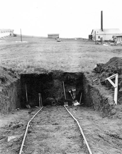
As early as 1909, coal was already being mined underground. By 1918, underground mines included the operations of the Peerless Mine east of Gillette. With the use of fresnos—earth scrapers drawn by two- or four-horse teams—Peerless operated from approximately 1918 to 1925, producing 20,464 tons of coal in all.
In 1923, near the Peerless Mine, the Wyodak Company began developing surface operations in the same coal seam. In 1925, Wyodak produced 33,579 tons of coal. Wyodak, purchased by the Black Hills Corporation on Nov. 1, 1956, is considered to be the oldest continually operated coal mine in the United States, according to the Wyodak company website.
Sources repeatedly assert that Wyodak was also for many years the largest surface coal mine in the world. According to Robert Henning, Registrar of the Campbell County Rockpile Museum, this claim probably refers to acreage and possibly depth, rather than to production. In 2011 Wyodak produced 5.7 million tons, with an estimated reserve of 256.2 million tons.
Oil and a growing population
The first commercial discovery of oil in Campbell County was in 1948. Later oil strikes at the Dead Horse Field on the Johnson-Campbell county line in the 1950s, at Belle Creek north of Gillette in 1955, and at Hi-Lite in 1967 created a long-term economic boom.
Between 1960 and 1970, the county's population more than doubled, from 5,861 to 12,957. Most of this growth occurred in or near Gillette from 1965 to 1970. Demographics also changed, with 11 percent of the population employed in mineral extraction in 1960 and 27.5 percent 10 years later. In 1970, the county's unemployment rate was 2.6 percent, one of the lowest in Wyoming.
Coal, oil and the boom of the 1970s
Coal and oil development in Campbell County nearly doubled its population again between 1970 and 1980, from 12,957 to 24,367. This growth was reflected in Gillette, with 7,194 in 1970 and 12,134 in 1980, a 69 percent increase.
By 1980 the proliferation of subdivisions and trailer courts just outside the Gillette city limits forced the department of Planning and Development to create a study zone, the Gillette Planning Area. According to Rumblings in Razor City, an oral history of Gillette compiled by Steve Gardiner, an additional 5,743 people were by 1980 living in the planning area, nearly half the population of the incorporated city. The total of citizens in Gillette plus the study zone was 17,877.
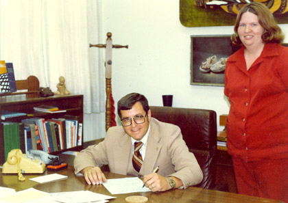
In the early 1980s, the average age in Gillette was approximately 28. Brought on by the influx of young adults to fill jobs in coal mining and oil drilling, this change pervaded many and diverse sectors. Mike Enzi, now a U.S. Senator, was 30 when he was elected Mayor of Gillette in 1974. He served until 1982. At the time of Enzi's election, the city attorney was 24. Kevin Doll, Managing Editor of the Gillette News-Record, was 29.
Phil Roberts, in his New History of Wyoming, Chapter 19, "Boom and Bust Again: Wyoming in the 1970s," describes boom-town conditions in much of the state that must have characterized Gillette as well. "Older residents, living off of Social Security or other fixed income, watched property prices spiral upward…with…rising assessments… Small business operators, accustomed to hire employees at the minimum wage, suddenly faced competition for laborers from the much better paying mines. … Town councils were overwhelmed with demands for water and sewer taps for housing developments."
In his 1974 paper, "Social Consequences of Boom Growth in Wyoming," University of Wyoming Sociologist ElDean V. Kohrs coined the term “Gillette syndrome," to refer to the myriad pressures felt by so many residents—and use of the term spread widely.
The stresses, as reported by Kohrs, included a higher rate of school drop-outs, more people on probation, and more arrests than in more heavily populated counties. For example, in 1970 there were 1,025 arrests in Campbell County (population 12,957), as compared with 674 in Sweetwater County (population 18,391) and 616 in Sheridan County (population 17,852).
Along with the stress on infrastructure, social institutions and individuals in Campbell County, however, came more opportunities than in many other parts of the state. Opportunities, as we have seen with Mike Enzi and other young people in Gillette, are not limited to the public sector. Carol Ullrich, a heavy-equipment operator, noted in her Rumblings From Razor City interview, "I can keep my job probably as long as I will want to work…If I had not come to Gillette, I would never have bought my apartments or this house."
Ironically, some students dropped out of school in boom times to take jobs in the mines at $30 to $50 per hour. Teachers sometimes followed suit or became land developers because their salaries did not grow at the boom-town rate of rents, grocery prices or property valuations. Phil Roberts best summed up these effects of energy development: "Many Wyomingites became prosperous during [boom] years, but there were contradictions of 'prosperity.'"
Thus, the economy and development of Gillette and its environs have been profoundly affected by energy production resulting from coal mining and oil drilling. Thirteen of the top 20 coal producers in Wyoming in 2011 operated in Campbell County, and these 13 produced a combined total of more than 426 million tons and employed 6,098 workers.
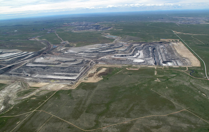
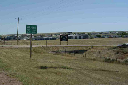
Wright and the Black Thunder Mine
Wright, Wyo., in southern Campbell County, is a company town created in the 1970s to deal with boom-time pressures resulting from coal development. The growth and planning of Wright was more orderly than in Gillette during its boom years, probably because issues of city planning, including housing, zoning, water and sewer, and recreation were extensively studied by the Atlantic Richfield Company (ARCO) before the opening of the Black Thunder Coal Mine and the resulting influx of workers.
The town’s name dates further back than the opening of the Black Thunder Mine. From approximately 1887-1953, in southern Campbell County, a total of 12 small post offices served the area. Usually located at a homestead or some other private residence, these post offices were open for as short a time as 10 months or as long as 33 years. The first Wright post office, recognized in April 1906, predated Campbell County in what was then Weston County. This office was located 45 miles southwest of Gillette at the home of Richard A. Wright, who served as the first postmaster. The Wright Post Office continued in two other locations until closing in 1942.
In 1976, Atlantic Richfield began to create the town of Wright for its employees, near Reno Junction at the intersection of Wyoming Highways 387 and 59. Before 1976, there were only two buildings at the junction: the Three-Way Stretch gas station and the Long Branch Saloon.
ARCO's first housing effort for its construction workers at the Black Thunder Mine was the Cottonwood Mobile Home Park with 108 units. By fall of the same year, there were 203 more units, plus an elementary school housed in a portable classroom.
From the beginning, and despite starting with mobile homes, ARCO officials displayed a vision beyond the early 20th-century, company-town model of company-store scrip and rows of identical houses for workers. This improvement was part of a larger social trend, explained by historian Robert W. Righter in The Making of a Town: Wright, Wyoming.
Near the middle of the 20th century, companies such as Richfield Oil, operating in the Cuyama Valley of California; the American Potash and Chemical Corporation in Trona, Calif.; and the Kennecott Copper Corporation in the southwestern U.S. improved existing company towns, primarily by building subdivisions, including water and sewer, and garbage removal. Indices such as employee turnover, accident rates and labor grievances improved.
Thus, when ARCO began to evaluate the feasibility of building an entire town, company officials had reason to believe this was a good investment. In 1975, consultants and developers were hired to study the problems inherent in providing housing and community services such as schools and medical care. The planning team also considered the addition of parks and a community center. The final proposal for housing included 1,381 houses and 500 mobile homes, at an estimated cost to ARCO of more than $14 million.
Yet ARCO's housing goals proved difficult to realize due to the inevitable delays of planning, surveying, permitting, construction and financing. By the early 1980s, the Cottonwood Mobile Home Park had grown to approximately 311 units, with a 75-space addition in progress. By Jan. 1982, just 150 houses had been built, with town houses and apartment buildings under construction or in place.
Progress in general community services was more noticeable. ARCO subsidized the Latigo Hills Shopping Mall, completed in October 1978. Unlike many malls in larger cities, Latigo Hills had a small medical clinic, a branch of the Campbell County Public Library, the Wright Post Office, and a 200-seat auditorium. Also in 1978, construction began on the Wright Community Recreation Center. This structure included meeting rooms, spaces for exercise classes and games and an Olympic-sized swimming pool. Later, Kerr-McGee assumed half the financial interest in the recreation center, that half amounting to $212,242. This was a gesture of sheer public relations, since Kerr-McGee had no financial interest in the Black Thunder Mine.
Wright was incorporated in 1985, making it Campbell County's second incorporated town. The population was then approximately 1,100. Wright is now served by its own newspaper, the High Plains Sentinel, and an outreach center for the Northern Wyoming Community College District is located in City Hall.
On June 1, 1998, the Black Thunder Mine was acquired by Arch Western Resources, LLC, as part of a larger purchase of ARCO's U.S. coal operations. In 2010, Black Thunder produced 116.2 million tons of coal, making it the top producer in the U.S.
The Future of Coal in the Powder River Basin
Currently for Campbell County, the 2013 Wyoming Business Directory lists nine different coal mining companies, mostly in Gillette. Among these are Alpha Coal West, Arch Coal Inc., Cloud Peak Energy, Foundation Coal West and Powder River Coal. Eighteen oil and gas producers are listed, including two in Rozet and one in Recluse. Some of the Gillette producers are Big Basin Petroleum, Callaway Oil and Gas, Marathon Oil and Skinner Oil and Gas.
And coal mining in the area may be on the wane. The Casper Star-Tribune, in a Jan. 28, 2013 article, "Wyoming coal production, jobs cut in 2012," reported that three percent of all Wyoming coal workers lost their jobs in 2012, a result of an eight percent decline in production. Reporter Adam Voge noted that "the vast majority of the job cuts came from mines in the Powder River Basin."
The Wyodak Mine cut more than 40 percent of its work force, from 116 in 2011 to 67 in fourth quarter 2012. A Jan. 25, 2013 Star-Tribune editorial noted that natural gas, cheaper than coal, is undercutting U.S. markets for coal, and that access to international markets, especially in Asia, is currently hobbled by the limited capacity of west coast ports and "political opposition and bureaucratic red tape."
Despite these downturns, in 2012 Campbell County was the richest county in Wyo., according to the Department of Revenue assessed valuations, at $5.8 billion; more than a billion ahead of Sublette County at $4.4 billion. Thus energy development, dominating this coal-and-oil rich area for nearly three quarters of a century, has ensured a strong economy for Campbell County.
Resources
Primary Sources
- Wyoming Newspaper Project. Gillette News, Jan. 14, 1892. Accessed Dec. 29, 2012, at http://www.wyonewspapers.org.
Secondary Sources
- ”Book of Lists 13”. Wyoming Business Report, 6 (Aug. 16-13, 2012), 33.
- Campbell County Historical Society. Campbell County: The Treasured Years. Marceline, Mo.: Walsworth Publishing Co., 1991, 5, 16.
- Campbell County Rockpile Museum. Accessed Jan. 7, 2013, at http://www.ccgov.net/departments/museum/.
- ________________________________________. “Campbell County History.” Accessed Jan. 7, 2013, at
- http://www.ccgov.net/departments/museum/history/campbell_county_history/index.html.
- ________________________________________. “Gillette History.” Accessed Jan. 7, 2013, at
- http://www.ccgov.net/departments/museum/history/gillette_history/index.html
- Center for Media and Democracy. “Sulfur Dioxide and Coal.” Sourcewatch.org, accessed Feb. 14, 2013 at http://www.sourcewatch.org/index.php/Sulfur_dioxide_and_coal.
- "Coal decline hits fuel's Western stronghold." Editorial, Casper Star-Tribune, Jan. 25, 2013, accessed Jan. 30, 2013 at http://trib.com/news/state-and-regional/coal-decline-hits-fuel-s-western-stronghold/article_1c023fb9-8af2-5150-88a5-402ae3eba9f5.html.
- Donahue, James, ed. Wyoming Blue Book: Guide to the County Archives of Wyoming. Vol. 5, Part 1, Centennial Edition. Cheyenne, Wyo.: Wyoming State Archives, Department of Commerce, 1991, 132-135.
- Gardiner, Steve. Rumblings From Razor City: The Oral History of Gillette, Wyoming, An Energy Boom Town. Self-published, 1985, 3-9, 33-51, 80-81.
- Henning, Robert. Personal email to the author, Feb. 6, 2013.
- Johnson, Emily, Financial/Statistical Technician, Wyoming Department of Administration and Information, Economic Analysis Division. Personal email to the author, Feb. 12, 2013.
- Kelley, Mary. Images of America: Gillette. Charleston, S.C.: Arcadia Publishing, 2010, 8, 61, 68.
- Kohrs, ElDean V. "Social Consequences of Boom Growth in Wyoming." Paper presented at the Rocky Mountain Association of the Advancement of Science meeting, April 24-26, 1974; Laramie, Wyo. Accessed Jan. 30, 2013 at http://www.sublettewyo.com/archives/42/Social_Consequences_of_Boom_Growt....
- Kornfeld, Marcel, George C. Frison and Mary Lou Larson. Prehistoric Hunter-Gatherers of the High Plains and Rockies. 3rd. ed. Walnut Creek, Calif.: Left Coast Press, Inc., 2010, 78, 260.
- Righter, Robert W. The Making of a Town: Wright, Wyoming. Boulder, Colo.: Roberts Rinehart, Inc., 1985, 62-63, 58-59, 86, 90.
- Roberts, Phil. A New History of Wyoming. Chapter 19, Boom and Bust Again: Wyoming in the 1970s. Accessed Jan. 30, 2013 at http://uwacadweb.uwyo.edu/robertshistory/New_History_of_Wyoming_chapter_19.htm.
- Voge, Adam. "Wyoming coal production, jobs cut in 2012." Casper Star-Tribune, Jan. 28, 2013, accessed Jan. 30, 2013 at http://trib.com/business/energy/wyoming-coal-production-jobs-cut-in/article_85eedeb6-ed92-594b-95f8-756299244b88.html.
- Wright Centennial Museum. From Belle Fourche to Antelope: History of Southern Campbell County. Gillette, Wyo.: Action Printing, 1991, 176, 184-185.
- Wyodak Resources. “History of the Mine,” accessed Feb. 17, 2013 at http://www.wyodak.com/history.html.
- Wyoming 2013 Business Directory. Papillion, Neb.: Reference USA, 2012, 182, 242-43.
- Wyoming Environmental Institute. Social Impact Analysis of Campbell County, Wyoming, Audie L. Blevins, Jr., and James G. Thompson. Laramie, Wyo.: Atlantic Richfield Company, 1974, 8-9.
Illustrations
- All but two of the photos are from the collections of the Campbell County Rockpile Museum in Gillette, and used with permission and thanks.
- The photo of Wright is from city-data.com. Used with thanks.
- The aerial photo of the Black Thunder Mine is from Ecoflight. Used with thanks.