Fossils found in the Weston County region date back 110 million years to the Cretaceous Period. The land was largely submerged, supporting thriving sea life—plants, shellfish and sharks, among others. A variety of prehistoric marine reptiles, including the sharklike ichthyosaurs and the long-necked plesiosaurs, as well as plant imprints and sharks’ teeth, have been discovered in the area.
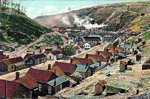
The coal-mning town of Cambria, 1908. Weston County was named for John Weston, who discovered coal there in 1887. Wyoming Tales and Trails
The sea receded many millions of years ago, however, and the land is now categorized as a Plains Grassland ecosystem, or Great Plains. Weston County is divided into four dominant land categories. The Pierre Shale Plains and Badlands, characterized by clay soil and gently rolling divides and hills around creeks and river valleys, make up about a quarter of the county. The Black Hills and Black Hills foothills, with steep-sided ridges, rocky hills and plateaus make up another quarter. The remaining half of the county is known as the Northern Rolling High Plains, flat lands with sandy soils.
Elevations range from 3,600-6,500 feet. Wind is fairly constant at an average 8 mph, with gusts up to 75 mph. The county receives just 10-19 inches of precipitation each year and has a 120-day growing season between freezes in mid-May and mid-September.
The county’s 1.5 million acres have various uses, with by far the largest amount—more than 1.2 million —used as range. Other uses include forest, pasture and crops. Ownership is predominantly private, with some industry, county, state and Bureau of Land Management and U.S. Forest Service land.
Early history
Weston County is located in the northeast corner of Wyoming, just south of Crook County and with its eastern border the South Dakota state line. The earliest inhabitants of the area were American Indians: the Black Hills feature prominently in folklore and stories of the Kiowa, Crow, Cheyenne and Lakota tribes, the last of whom were pushing the Crow further west by the early 1800s.
The first whites in the area may have been Louis and Francois de la Verendrye, Canadian French fur traders who in 1742 and 1743 explored west from the Big Bend of the Missouri River at least as far as the Black Hills. The land came under nominal United States control in 1803, when representatives of President Thomas Jefferson negotiated purchase of the Louisiana Territory from France. Indians still controlled it, however, and continued to do so for three-fourths of a century.
In June 1834, Congress designated all non-state or non-territory land west and east of the Mississippi River as Indian Country. What’s now Weston County officially became part of the new Nebraska Territory in May 1854. Later it was part of Dakota Territory, then, briefly Idaho Territory, then Dakota Territory again and finally, on July 25, 1868, was included as part of the brand-new Territory of Wyoming. Even then, however, any white people who passed through what’s now northeastern Wyoming kept on going.
Early industry
Indians knew of gold in the area but, hoping to preserve their land and lifeways, kept the location of this treasure a secret. Their efforts worked for some time. Westbound settlers and miners flooded the Oregon/California/Mormon Trail across what’s now central Wyoming in the 1840s, 1850s and 1860s, but other than soldiers, few white people came to the new Wyoming Territory to stay until after the completion of the Union Pacific Railroad in 1869.
Northeastern Wyoming remained in tribal hands the longest of any part of the territory. Cheyenne and Lakota Indians fought wars in the 1860s to keep it that way. In 1874, Colonel George Custer led a 1,000-man expedition into the Black Hills, discovered gold, and soon, miners and settlers were pressuring the government to persuade the tribes to cede their lands. The military campaigns of 1876, which ended in Custer’s defeat and death, finally drove all the tribes out of northeastern Wyoming Territory and onto reservations in what are now Montana, the Dakotas and Oklahoma the following year.
Beginning in 1877, herds of cattle were trailed to Wyoming from Texas, and cattle raising soon became a central part of the economy of Crook County, half of which later became Weston County. Many businessmen from the East and from Britain purchased cattle and hired cowboys to care for their stock as the industry grew. A devastating winter in 1886-1887 decimated the herds, and many investors went broke. But some cowboys and their wealthy backers were determined, and some large herds remained.
The cattle industry could be lucrative but was notoriously expensive to break into. New homesteaders in the area began bringing in sheep, which required a lower initial investment than cattle. These people in the late 1880s created Irontown, which is now Upton, Wyo. Historians believe the town began as a place where cowboys, ranchers, homesteaders and especially sheep men could obtain supplies.
Newcastle, Wyo., was founded around the same time by the Chicago, Burlington and Quincy Railroad, then building across Wyoming’s northeast corner from Nebraska to Montana on a route planned to take advantage of ready coal supplies to fuel its locomotives.
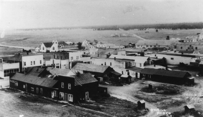
This bird’s-eye view of early Upton shows houses and buildings that sprang up around the Burlington tracks. Alice Schuette Collection, Weston County Historical Society.
In 1887, John Weston and Frank W. Mondell found coal deposits in what would soon become Cambria, a coal settlement. By 1890, the mine employed 750 people, and the camp’s population was 1,500, with 23 nationalities represented. Newcastle, meanwhile, was founded in 1889 and the Burlington tracks arrived soon afterward.
Weston County was eventually named for John Weston. Mondell, a businessman with many interests, was Newcastle’s first mayor. He was elected to the state Legislature in 1893, and to the U.S. House of Representatives s in 1894, where he served one term. He was elected again in 1898, and after serving 12 terms, ran for the Senate in 1922—but lost to the popular Democratic incumbent, John B. Kendrick.
County formation
The final Wyoming Territorial Legislative Assembly created Weston County on March 12, 1890, and named it for John Weston to honor his discovery of the coal deposits. Crook County was split in half, and the southern half was designated Weston County.
Soon after, Territorial Governor Francis E. Warren appointed George H. Purmort, Harry C. Hensel and Ralph A. Weston to the board of organizing commissioners for the county. In early April, voters selected Newcastle as county seat. Officers such as commissioners, county clerk, attorney, treasurer, sheriff, school superintendent, justices of the peace and constables were elected May 14, 1890.
Early economic troubles
After being split from Crook County, Weston County remained liable for part of Crook County’s debt under the territorial law. Weston County’s portion was $14,500, and despite levying the maximum allowable tax, debt problems stuck doggedly to the new county for several years. In October 1890, the county issued bonds in the amount of $20,000. Residents were uninterested in buying them, however, and the debt continued to climb. The county again issued $20,000 in bonds in February 1891, and on April 8 the bonds were bought by the Bank of Newcastle.
Finances were still tight the following November, however, and the cash-strapped county commissioners voted, as a stopgap measure, to cut the jobs of deputy county officers—deputy sheriff, deputy county clerk, etc.—that they had added to the county payroll just the year before.
Things went from bad to worse when the nation was swept by the Panic of 1893, starting a depression that lingered most of the decade. Tax revenues declined, and the county was still unable to pay its bills. Three banks sued Weston County in September 1893 for nonpayment of more than $10,000 in county warrants. To compensate, commissioners issued more bonds, nearly doubling the debt to a total of nearly $40,000.
In April 1896, the Grand Island and Northern Wyoming Railroad, a Burlington subsidiary, refused to pay taxes to Weston and Crook counties, citing debts both counties owed the company. Weston and Crook county cooperated to file a lawsuit to collect the taxes, and the counties ultimately received their tax money.
Still, hard times persisted and the county was sued again in March 1897 for failure to pay for a variety of contracts and services rendered. Although officials fully acknowledged the debt, county coffers lacked enough funds to pay what was owed. Finally, in 1899, the economy began to improve, and county finances with it. On Feb. 16, 1901, Weston County commissioners approved the purchase of real estate in Newcastle for expanded county offices, a sign they had money to spare at last.
Oil industry
The first oil wells in Weston County were drilled between 1890 and 1901. The largest oil companies, Mike Henry Oil Company, Illuminator Oil Company and M.J. Coyle, contributed to this boom. Demand for crude oil during World War I helped make the industry profitable throughout the United States.
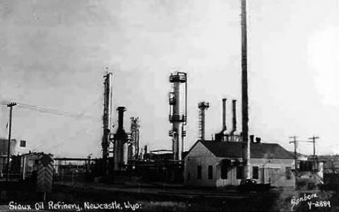
The oil business has dominated Weston County's economy since the 1920s. The Sioux Refinery in Newcastle, 1953. Wyoming Tales and Trails.
In March 1920, the discovery of a gusher near Osage, Wyo., halfway between Newcastle and Upton, heralded the beginning of a new and continuing era of prosperity for Weston County. The oil well produced between 1,500 and 2,500 barrels of oil per day.
People from throughout the nation, lured by the promise of work and wealth, began arriving in Weston County—mostly workers and a few families. A second significant well was discovered in July of the same year, and more companies from around the country set up drilling rigs. Refineries were built in Osage, Newcastle, Four Corners, Red Butte, Thornton and other small towns. Land prices skyrocketed to $1,000 per acre in Weston County, and with the throng of workers came increased violence, petty crimes, oil disputes and con artists.
As demand for oil increased, interest in bentonite grew. Weston County is rich in bentonite, a fine clay used primarily in oil drilling to flush cuttings out of the hole as the well is being drilled, though it has many other uses as well. Several bentonite-refining plants were constructed, with the first at Clay Spur near Osage and later plants in Newcastle.
After World War I, falling demand for oil slowed the industry, and the boomtown of Osage went bust. Also after the war, steeply falling agriculture prices hit farmers and ranchers hard, and their difficulty paying their debts in turn was hard on the small-town banks that lent them money. Industrial workers left the county, looking for the next opportunity, and Weston County towns became quiet, sleepy family areas with little sustainable industry.
By the mid-1920s, Weston County, like much of the rest of Wyoming, was in a depression well before the stock market crash of 1929, which signaled the start of the Great Depression nationwide.
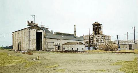
Weston County's first bentonite plant at Clay Spur, near Osage, opened in the 1920s and was abandoned by the time this photo was taken in 1989. The industry is still important in the area. Wyoming Tales and Trails
Bentonite was the first industry in Weston County to start coming out of the slump. Demand had increased as more and more uses –cement and plaster, cosmetics, insecticides, herbicides and textiles—were found for the product. In October 1935, the bentonite refineries in Weston County began working 24-hour shifts to fill all the new orders. By the end of 1939, Weston County bentonite was being shipped all over the United States and to Canada and South America. By that time, war had begun again in Europe.
As another global conflict approached, demand for oil and bentonite increased, and agricultural prices rose. So-called “World War II industries” in the county included beef cattle, dairy cattle, brood sows and egg production. Workers from Arizona and New Mexico—people of Indian and Mexican heritage—came to Weston County to work as sheepherders, lambing hands, sugar-beet harvesters and general farm workers.
There had been small sawmills before in Weston County, but the Berman Sawmill, opened by local businessman Dan Berman in 1950, was the first to operate on an industrial scale. It created 20 jobs, and soon was producing 250,000 board feet of lumber per month, primarily from timber cut in the Black Hills. The sawmill finally closed in 2000.
Additional oil wells were discovered during the war years and immediately afterward, and another boom-bust cycle began. This oil boom peaked in the mid-1950s. Workers again rushed to the county, and the population jumped from a pre-war total of 4,958 in 1940 to 7,929 in 1960. The industry slowed by the late 1950s, but the continuing operations of the sawmill softened the economic impact of the decline of oil.
Weston County today
Of Wyoming’s 23 counties, Weston County ranks 18th in size at about 2,400 square miles, and 20th in population as of the 2010 census count of 7,208. It includes two towns, Upton and the county seat of Newcastle as well as the unincorporated communities of Hill View Heights, Osage and Four Corners.
The boom-bust cycle continued throughout several decades, with a boom in the 1960s bolstered by the national oil embargo in the 1970s. When prices began to fall in 1980, another bust set in. As of early 2012, prices again are high, and while most oil drilling now takes place outside the county’s borders, the industry is still an active part of the area’s economy. Newcastle’s oil refinery, long owned by the Wyoming Refinery Company, was bought by Black Elk LLC, of Houston, in 2011, with plans to upgrade pollution protections and increase output.
On Aug. 24, 1969, the Burlington Railroad suspended passenger train service in Weston County. The railroad continues as a major employer because of coal transport from two mines, Arch Coal Company’s Black Thunder Mine and Rio Tinto Energy America’s Jacobs Ranch Mine, outside the county near Wright, Wyo.
Many residents own cattle and sheep ranches. Weston County Health Services in Newcastle provides employment for medical and social workers and others. The Northern Wyoming Mental Health Association, also in Newcastle, was established in April 1961 to provide care for community members, specifically war veterans, and the 41-bed Weston County Manor opened in 1969 to assist elderly members of Weston County. Both facilities continue to serve the community today. The Wyoming Department of Corrections operates the Wyoming Honor Conservation Camp & Wyoming Boot Camp, which is located just north of Newcastle and provides work experience for prisoners who have met good behavior standards.
Resources
Donahue, Jim. Wyoming Blue Book. Administrative History of Weston County, Vol. V, Part I, Department of Commerce. Cheyenne: Wyoming State Archives, 1991, 832-838.
“Historical Decennial Census Population for Wyoming Counties, Cities and Towns.” U.S. Census Bureau figures. Accessed 3/28/12 at http://eadiv.state.wy.us/demog_data/cntycity_hist.htmhttp://eadiv.state.wy.us/demog_data/cntycity_hist.htm
The Weston County Heritage Group. Weston County, Wyoming: The First 100 Years. Dallas: Curtis Media Corporation, 1988, 1-75.
U. S. Department of Agriculture. Vegetation and Environmental Features of Forest and Range Ecosystems, Agriculture handbook No. 475. , July 1977, pp. 52-54
The color postcard of Cambria in 1908, the photo of the Sioux Refinery in Newcastle and the photo of the abandoned bentonite plant at Clay Spur are all from Wyoming Tales and Trails. Used with thanks.
The bird’s-eye view of Upton is from the Alice Schuette Collection, Weston County Historical Society. Used with permission and thanks.