Stand on South Pass: Wallace Stegner, the Wind and the West
WyoHistory.org opinion
(Editor’s note: Will Bagley delivered this essay at the Wallace Stegner Centennial Summit at Western Wyoming Community College in Rock Springs, Wyo. Sept. 25, 2009)
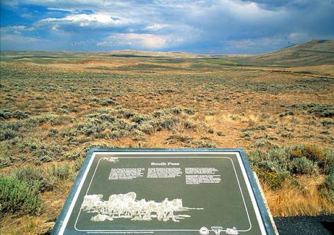
Stand on South Pass now and you will find it as still and peaceful as if no clamor of empire had ever surged through it. Antelope will drift close to see what you are up to. No smoke stains the dark blue sky. The riotous rendezvous of the fur hunters, held nearby for a dozen years after 1825, have left neither echo nor mark, not even a tepee ring. The wheels that between 1836 and 1869 rocked and creaked and squealed up the Sweetwater and down past the westward-falling trickle of Pacific Creek have left ruts that are still visible among the sage and bunchgrass if you look hard, but modern travel does not go this way. Both Interstate 80 and the Union Pacific Railroad cross the Continental Divide west of Rawlins, and again west of Red Desert, Wyo. All that crosses South Pass now is state Highway 28, a secondary road. And here is a lesson, not only in history, but in the fallibility of prophecy based on false premises.[1]
For the last year, thanks to the generosity and public spirit of his former employers at Aramco, now the Chevron Corp. I have helped commemorate the 100th birthday of Wallace Stegner, the great writer whose long career made him the voice of the American West. For four decades, Stegner’s work has profoundly influenced how we as Westerners see our native land. Like everyone else who hopes to write intelligently about the place, I am deeply touched by his work as I wrestle with the most important issues confronting the West. Again and again I find new insights and meaning in his essays, histories, and novels.

Time has deepened my appreciation of Stegner’s eloquent defense of the land we love. His 1960 Wilderness Letter helped persuade Congress to pass the Wilderness Act in 1964 and inspired a generation of environmentalists, but as a hardheaded realist, he was no friend of “blind preservationism in all circumstances.” He knew well that people had to make a living in this hardscrabble arid landscape, and he strove to find a middle ground between the toadstool worshippers and land-grabbing sagebrush rebels. Last month, I was fortunate to make a presentation on Stegner’s “Legacy of Red Rock and Eloquence” at Moab, Utah’s public library: An older gentleman commented he’d never had much truck with environmentalists, but Stegner’s approach to managing Western lands responsibly sounded like common sense. It was and is. Wallace Stegner’s vision points the way to a balanced resolution to the long and bitter war over the fate of the American West.
The staggering beauty of Utah’s mountains and the Colorado canyon country captured Stegner’s heart, but he was clear-eyed enough to see the region as “rootless, culturally half-baked.” His best work evokes the conflicts and contradictions that still haunt the American West. Beyond the Hundredth Meridian, his epic biography of John Wesley Powell, challenged the dream West of inexhaustible resources and rugged individualism so dear to the popular imagination. “It was as though someone had thrown a rock through the window,” Bruce Babbitt, later secretary of the Interior in the Clinton administration, said upon first reading it. The book gave him a “new way of thinking about the American West.” Stegner reminds us that aridity is our region’s defining characteristic and makes us appreciate the “dry clarity and sharpness in the air,” and the horizons “that either lifted into jagged ranges or rimmed the geometrical circle of the flat world.”[2]
Stegner’s appreciation of the importance of place rings particularly true for one place that speaks, not only to me as a historian and writer, but to our entire nation’s past and future: South Pass. For the last decade, thanks to the seriousness with which the National Park Service and the Bureau of Land Management administer the public lands that belong to us all, I have investigated the role America’s overland wagon roads played in the creation of the land we call home.
Five years ago I contracted to provide both agencies “with guidance in the management, protection, treatment, and interpretation of trails-related historic properties and landscapes in the South Pass area of Wyoming,” to assist in establishing the “region’s historical significance and setting priorities for treatment of and project funding for Federally managed historic properties within” South Pass. Specifically, I was to “identify and justify appropriate boundaries for a South Pass Rural Historic District nomination to the National Register of Historic Places, and prepare a nomination package.” As the task order noted, “A portion of the area is already nationally recognized as the South Pass National Historic Landmark, but the boundaries of the Landmark have not yet been finalized.”[3]
Thereby hangs a tale. The 1935 Historic Sites Act “declared that it is a national policy to preserve for public use historic sites, buildings, and objects of national significance for the inspiration and benefit of the people of the United States.”[4] By 1959, the government had assembled extensive reports and “a classified list of sites and buildings of exceptional value” that was kept secret. “Much invaluable material has languished in Government files, unused,” National Parks Service Director Conrad Wirth complained to Secretary of the Interior Frederick Seaton. Wirth proposed creating a “category of Registered National Historic Landmarks.”
The administration announced the program in October 1960, and South Pass was among the first sites Seaton nominated that December.[5] Shortly before leaving office on Jan. 20, 1961, President Dwight Eisenhower designated South Pass and 50 other properties as National Historic Landmarks. Secretary Seaton called South Pass “one of the great landmarks on the Trail.” South Pass was among the first sites listed on the National Register of Historic Places after it was authorized by the National Historic Preservation Act in 1966, but as was standard practice at the time, no one defined boundaries for the landmark, nor have they been drawn since, although the process for defining NHL boundaries was defined in 1974.[6]
This is a telling anecdote, first because it harkens back to a different age, when a retiring conservationist Republican president’s last act would be to help preserve our nation’s past, and when a new Democratic administration could hire our nation’s leading environmentalist to advise the Department of the Interior. In his short stint with the Kennedy administration, Wallace Stegner never developed a case of Potomac fever or acquired a taste for Washingtonian bureaucracy, but his service made him a founding father of the progressive age that bequeathed us the Wilderness Act and four new national parks for Utah.
As Page Stegner observed, his father “always talked about himself as a reluctant environmentalist.”[7] It was his friendship with historian and critic Bernard DeVoto that made an activist out of Stegner: From his Harper’s easy chair, DeVoto pretty much invented today’s environmental movement. After his sudden death in 1955, DeVoto’s mantle as a voice for conservation and the protection of public lands fell on Stegner’s shoulders. The way Stegner edited Alfred Knopf’s passionate contribution to This Is Dinosaur, “the first real fighting book the Sierra Club published,” exemplifies his ambivalence about activism, even in defense of a cause he loved, and the deeply conservative principles that influenced everything he did. Stegner deleted, altered and rewrote Knopf’s angrier passages and personal attacks. “We are trying to sound objective, good-tempered, and without personal rancor (though we burn inside),” Stegner explained.[8]
Stegner and his mentor shared both an appreciation and love for “the historic portal, South Pass,” which DeVoto called “the gate through which the United States would reach its empire.”[9] “Here for forty years of exploration, trade, and emigration westering Americans felt . . . that they had reached the West.” From South Pass, DeVoto later said, “the architecture of the West is visible, and the leverage of its waters.”[10] Stegner’s biography of his old friend inspired one of the best descriptions of the place ever composed:
Off the main road now, and not often visited, South Pass is one of the most deceptive and impressive places in the West. Stop there and watch the cloud shadows go over, and see the white rumps of antelope move among the sage, and study the deep, braiding ruts that the wagons made as they fanned out and came down the long, even slope from Pacific Spring, on the western slope at last— stop there off the road [state Highway 28], with your motor shut off, and listen to the wind, which breathes history through dry grass and stiff sage, and smell dust and distance, and look eastward over the gentle rise to where you know the Sweetwater and Devil’s Gate and Independence Rock and the last crossing of the Platte recede on backward toward the United States. Then turn and look west, down the long, easy slope toward the Green, and you can believe you understand something about the spirit of the Völkerwanderung that moved America westward. It was DeVoto’s major theme, and he wanted South Pass to speak to him.[11]
In his great chronicle of Mormon westering, The Gathering of Zion, Stegner captured how:
Wyoming 28 follows the old route over South Pass only approximately, but for the ordinary pilgrim approximation is close enough. That high flat saddle is still as it always was, pushing up against the sky, with the Oregon Buttes southward and the Wind Rivers whitening the north, and that too is a good place to sit on a rock and feel history. Short of South Pass City the road curves off north to Lander, and then comes back southeastward again until it picks up the Sweetwater at the corner of the Rattlesnake Range, near Split Rock and Ice Spring. At Martin’s Cove, just above Devil’s Gate, the pilgrim may stop and try to imagine how that cliff-backed river-bottom might have looked to a shivering, exhausted, starving handcart emigrant in November 1856.[12]
Silence is the most striking feature of South Pass. You can almost always hear the wind either howl or whisper, and you might hear the groan of a semi laboring up the grade a mile to the west. But the spot is always quiet, very quiet, with a silence that is almost sacred. Some say the Shoshones called South Pass ”the place where God ran out of mountains.”
Between Marias Pass near the Canadian border and Guadalupe Pass not far from Mexico, South Pass is the only easy way to cross the massive cordillera of the Rocky Mountains. More than 500,000 Americans crossed the Continental Divide at South Pass between 1840 and 1870 on their way to new homes in the West—the largest peaceful migration in human history.
Beyond a simple high spot in the topography, you can start a good argument about where South Pass begins and ends—and an even better one about what it means. The Shoshones, whose homeland surrounds the pass in all five directions (the fifth is up) and 36 compass points, never debated the point.
South Pass is inevitably bound to the Sweetwater River, and conceptually, the “Gateway to the West” began where the old wagon road to Oregon met the stream at Independence Rock, the great granite turtle lying on the plain not far from Devil’s Gate, where the Sweetwater slices through the Rattlesnake Mountains.
Here between 1824 and 1912 almost a million westbound home-seekers began their 99-mile walk up the Sweetwater to the Continental Divide and their private El Dorados in the promised lands of Oregon, Washington, Utah, California, Nevada, Idaho and Montana. South Pass ends where the trails west crossed the Big Sandy River and entered the kingdom of sage and rabbitbrush, grouse and greasewood, coyote and cactus, jackrabbit and juniper.
To people who had grown up in a landscape enclosed in well-watered woods and greenery, the vast horizons of the arid lands looked like hell incarnate: To their descendants who ended up here, it looks like home. “Whenever I return to the Rocky Mountain states, where I am most at home,” Stegner wrote, “. . . the smell of distance excites me, the largeness and the clarity take the scales from my eyes, and I respond as unthinkingly as a salmon that swims past a river mouth and tastes the waters of its birth.”[13]
The transformation of how many Westerners see and understand their native land may be Stegner’s most lasting legacy. He knew firsthand the human cost of the West’s boom-and-bust treasures and how tough and essential it was for ranchers, farmers and miners to wring a living out of such unforgiving country. Out west, as Mark Twain might have said, “Whiskey is for drinking; water is for fighting over,” but it rings true at the dawn of this thirsty century. Stegner showed us both the possibilities and perils of our “terrible and beautiful wasteland” and exposed the futility of trying to build Xanadu on the Salt Flats.
Not long before Stegner died, journalist Brian Meehan asked how he now felt about the “geography of hope” he once found in the American West. “I was describing a psychological condition, not necessarily an economic probability,” Stegner said. He didn’t know if that hope endured: “We’re trying to make [the West] more populous than it can be,” he said. “That’s a problem, but it will revert. That’s the way the country teaches you lessons.”
If the drought that hit California in the late 1980s “had gone on eight years instead of six, you would have seen a lot more exodus out of California. I think you already do because of crowding and city conditions in those places where there isn’t enough water, and we all go up and Californicate Oregon, Washington, Idaho, Montana.”[14] When asked in 2008 how he thought his father would look at the current state of the environment, Page Stegner said, “I think he would be pretty hopeless. I think it would be the geography of hopelessness.”[15]
When it comes to the landscape of South Pass, it would be nice if Billy Wilder’s immortal words, “The situation is hopeless, but not serious,” applied. South Pass’s future may be seriously hopeless. The Green Revolution dreamworld has increased rather than diminished threats to the integrity of its landscape. Due to the proposed Altamont pipeline, the National Trust for Historic Places included South Pass on its list of eleven most endangered sites in 1995, noting the “need to document the South Pass Historic Landscape and nominate the entire 100,000 acre area to the National Register of Historic Places.”[16]
Market conditions led Altamont to delay the project, however, and ultimately the BLM rejected it. “To protect the visual and historical integrity of the historic trails,” the Rock Springs, Wyo., BLM Field Office in 1997 designated 53,780 acres of BLM-administered public lands in the South Pass Historic Landscape as an area of critical environmental concern (ACEC) in its Green River Resource Management Plan.
The plan protected the landscape of 16.42 miles of trail within a six-mile wide corridor along the Oregon, Mormon Pioneer, and California National Historic Trails, with a two-mile wide corridor along the Lander Cutoff. The ACEC prohibited future rights of way across public lands for “utilities, transmission lines, communication sites, roads and highways” that would adversely affect the historic landscape and closed some 33,700 acres to development that could adversely affect the view. It left about 20,080 acres that are not visible from the trail open to operations that were “subordinate to the landform and not visible from the historic trails, and provided that environmental analysis indicates that the visual integrity of the area can be maintained.””[17]
At the same time the Lander Field Office in early 2012 proposed much more substantial protection for the 100 or so miles of historic trail from Independence Rock to Burnt Ranch near South Pass. These provisions prohibit most industrial development, including wind turbines, within five miles on either side of the trail, effectively establishing a 10-mile-wide buffer. The plan has met resistance from industry groups, the Fremont County Commissioners and the office of Wyoming Gov. Matt Mead, however. A final ruling is likely sometime late in 2012.
South Pass has always been a hard place to get rich—and a terrible place to get rich quick. A handful of speculators—the fur-trade barons who traded supplies for pelts at a dime on the dollar and the Mormon ferry owners who started the 1867 gold rush—did get rich promoting South Pass, but for every person who hit the big jackpot, a hundred went bust, lost everything they owned and loved on earth or died young. The toughest of the homesteaders who proved up their 160acre claims along the Sweetwater coaxed enough cattle through the brutal winters to buy out their less resilient neighbors and build viable ranches. These incredible families created and protected the landscape that makes South Pass so remarkable today.
South Pass has escaped many of the disasters that have ravaged the rest of the West: The sweeping view from its summit is little changed since 1850. Two miles below the Continental Divide, the green oasis of Pacific Springs still boils up “through the sod as cold as ice itself,” just as it did in 1852 for emigrant diarist Parthenia Blank. In 2006, an estimated 7,487 visitors left the pavement and crossed three miles of gravel road to the see the trace of the Oregon, California, Mormon and Pony Express National Historic Trails—all one trail at this point.
America’s past has an almost magical ability to disappear: A sprawling metropolis surrounds the Alamo and Interstate 80 runs right over one of the Donner Party’s cabins. But beneath the looming majesty of Pacific Butte, South Pass endures. “Recovering the Lost Trail has a deeper meaning than merely gratifying a whim or satisfying a feeling of curiosity,” trail-history booster Ezra Meeker said in 1915, and it is still true.
The only quick fortunes to be made at South Pass are still founded on economic principles as noble as the derivatives and subprime mortgages that fabricated enough toxic assets to make a few scoundrels fabulously wealthy and drown the rest of us. If wind turbines ever do materialize at South Pass, they will be based on the same American free-market gospels embraced by P. T. Barnum and Mel Brooks: Barnum realized there’s a sucker born every minute, and Brooks showed the path to great wealth is seldom straight and narrow.
In Brook’s movie (and later Broadway musical) The Producers, two speculators conspire to get rich producing a bomb: when it fails, they plan to pocket the 25,000% of the show’s costs that they’ve raised from investors—see Barnum’s “suckers.” Instead, Springtime for Hitler becomes a hit: A fate that, according to gas-patch lore, overtook a Texas oilman not far west of South Pass. He and his fellow crooks oversold shares in a Pinedale, Wyo., gas field, banking on not finding any gas. When they hit a gas gusher, they supposedly solved the problem by pouring concrete down the problematic prospect hole.
The latest get-rich-quick South Pass scam is built of nothing more than air—moving air—wind. A place as windy and remote as South Pass must be an ideal spot for a wind farm, right? Wrong: These are actually industrial wind power plants, deceptively called “farms,” which they are not. The impractical wind schemes being pitched for South Pass would require backup coal-fired plants to take over when the wind stopped or roared. Most of the electrical juice generated in Wyoming would disappear on its way to California. The scam only makes economic sense as part of carbon credit shell game that would actually promote burning more coal. The Secretary of the Interior recently proposed building some 186,000 wind turbines, which would cover as much land as West Virginia and require 19,000 new miles of high-voltage transmission lines.
“Is the federal government showing any concern about this massive intrusion into the natural landscape?” U. S. Sen. Lamar Alexander of Tennessee asked recently. “Not at all. I fear we are going to destroy the environment in the name of saving the environment.” Renewable energy, the senator pointed out, “is not a free lunch. It is an unprecedented assault on the American landscape.”[18]
Bernard DeVoto wrote, “The wind in the Pass is usually moderate and silent,” but “it is an avalanche down the eastern gulches of the range.” Generating power profitably from moving air requires constant and steady zephyrs, not the temperamental winds ranging from gusts to gales that whisper or roar over South Pass. The arctic hurricanes that blast through the great gap every winter might make it less than an ideal location to maintain a stand of ungainly wind turbines—but if you bet your bottom-dollar that a few hardy entrepreneurs already have schemes to get in on the ground floor of Wyoming’s wind boom, you’d win. They have yet to contact the Shoshone Nation, which never extinguished its right to the powers that dwell in the fifth direction, up.
Today, “the Oregon Trail is in the way of a gold rush that will demolish part of our history and leave us poorer,” writes my friend Stafford Hazelett of the Portland, Ore. Tribune wrote in 2009. “If windmills were about generating electricity instead of cash, we could protect the Oregon Trail and have wind energy.”[19]Recently, many corporations have filed multiple applications for MET—that is, meteorological—towers to test the Shoshone tribe’s winds blowing over the old wagon roads that the Rock Springs, Casper, and Lander BLM field offices administer. Applications “cover lands along pretty much the whole trail corridor,” one BLM staff member at Lander notes.”[20]
One company--Pathfinder Wind--responsible for most of those applications, seems to have turned its sights instead on wind development in southeastern Wyoming. And the U.S. Senate’s refusal in March 2012 to extend substantial federal tax breaks for wind-power developers beyond the end of 2012 has introduced a new level of uncertainty into the market for wind-generated electricity. Some developers and politicians claimed at the time of the vote that the wind-power industry will flounder and fail without the tax credits.[21]
All these things could change, of course. But South Pass, its history and vistas may be safer now, more or less, than they have been in recent years. We’ll see what happens.
“South Pass is one of the few places where you can stand in 2006 and 1846 at the same time,” observed historian and longtime former BLM archeologist Terry Del Bene. “That’s pretty special. We’re running out of places like that.” As early as 1869, historian J. Ross Browne predicted that Americans would make pilgrimages to South Pass.
Not many years ago, Wyoming native Tom Bell, whose great-great-grandmother crossed South Pass during in the 1850s noted, “I can stand on South Pass and close my eyes, and hear the hoofbeats of the Pony Express riders, the cracking of ox-team drivers’ whips, the creak of wagon wheels, the voices of women and children.” For those who value its living connection with history, South Pass represents a national treasure that we can either squander or save for future generations.
“In the silence and solitude of this mountain retreat, with great peaks whose snow-white crests were hidden from view by clouds,” wrote Jacob Pindell Prickett after crossing South Pass in 1854, “it seemed that this was not the world—the busy, teeming world of commerce, and trade, and civilization—that I had been a part of but a few short months before, but a new world which had remained as it came from the Creator’s hand—a world of solitude, grandeur, and peace.”
This remote spot is not a grand spectacle like Yellowstone Falls or the Grand Canyon, but it has a haunting, quiet beauty all its own that has escaped the ravages of progress. South Pass is one of the few places where my daughter and granddaughter can stand today and see what their ancestors saw in 1850 and 1854 and 1864—the view that overwhelmed Edwin Bryant in 1846 with its “sublime and solemn solitude and desolation.” As Wyoming native Joe Greig says, “My grandfather and father both mined gold in the South Pass-Atlantic City areas, [but] the gold rush is over for this country. It’s time to mine the historical and inspirational gold this area holds.”[22]
For those of us who treasure the past and find both comfort and trouble in its study, South Pass is a history-haunted place. The ghosts of South Pass and the creaking and screeching of their wagons carried in the wind may be imaginary, but to us they are as real the 10,000 graves that mark their passage.
Thanks to generations of ranchers who preserved and protected this remote, historic and hardscrabble place, it looks much like the terrain that a dozen of my ancestors crossed 150 years ago. It is a living part of our heritage, an American treasure. All of this—the silence this very special place keeps, the imaginings it sparks, the memories and heritage it holds, the stories it tells— must be preserved, so that our grandchildren and their children too can see and feel South Pass’s magnificent legacy. The example of Wallace Stegner’s life cries out that we must take a stand on South Pass: We simply cannot afford to squander or waste this majestic and timeless place.
In 2014, the Lander Field Office of the Bureau of Land Management issued its Resource Management Plan covering its part of South Pass. The RMP limits rights of way to designated corridors, oil and gas development, and mining. It closes the area to phosphate mining, wind energy development, and limits sand and gravel quarries to spots not visible from the trails. It protects the existing character of the landscape and will keep future impacts low.
Resources
Illustrations
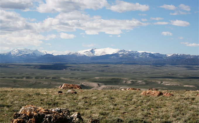
- The photo of South Pass is by Barbara Dobos. Used with thanks.
- The photo of Wallace Stegner is from Google Images.
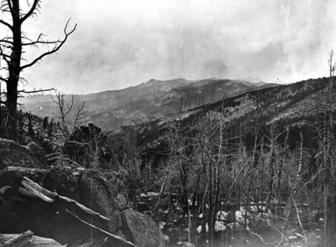
- The photo of the Wind River Mountains north of South Pass is by William Henry Jackson, 1870. USGS photo, used with thanks.
[1] Wallace Stegner, Marking the Sparrow’s Fall, 242–43.
[2] Wallace Stegner, Where the Bluebird Sings to the Lemonade Springs, 17.
[3] Task Order for Modified Cooperative Agreement between Prairie Dog Press and the National Park Service, in Collaboration with the Bureau of Land Management, for Preparation of an Historic Context and National Register Nomination for the South Pass Segment of the Oregon and California National Historic Trails, 29 August 2004, copy in author’s possession.
[4] U.S. Congress, Historic Sites Act of 1935, 16 U.S.C. sec. 461-467.
[5] Wirth to Seaton, 30 June 1959, in Mackintosh, “The Historic Sites Survey,” 46–47, 135–38.
[6] USDI, BLM, Environmental Assessment for Dickie Springs Placer Gold Exploration, 8-70.
[7] Page Stegner Interview, KUER Wallace Stegner Documentary, 15. www.kued.org/productions/wallacestegner/transcripts/pageStegner.pdf
[8] Fradkin, Wallace Stegner and the American West, 188.
[9] Bernard DeVoto, Across the Wide Missouri (New York: Houghton-Mifflin Co., 1947), 53–54.
[10] Bernard DeVoto, The Western Paradox: A Conservation Reader. Edited by Douglas Brinkley and Patricia Nelson Limerick. Foreword by Arthur M. Schlesinger, Jr. (New Haven: Yale University Press, 2000), 204-05.
[11] Wallace Stegner, The Uneasy Chair: A Biography of Bernard DeVoto (Garden City, New York: Doubleday & Co., 1974), 292–93.
[12] Wallace Stegner, Gathering of Zion, 306.
[13] Wallace Stegner, Where the Bluebird Sings to the Lemonade Springs, Preface.
[14] Brian Meehan. “Wallace Stegner: The Heart of the West.” The Portland Oregonian, April 18, 1993. Digital copy at http://blog.oregonlive.com/oregonianextra/2007/07/wallace_stegner_the_heart_of_t.html [30 March 2009].
[15] Page Stegner Interview, KUER Wallace Stegner Documentary, 15. www.kued.org/productions/wallacestegner/transcripts/pageStegner.pdf
[17] Bureau of Land Management, Green River Resource Management Plan.
[18] Lamar Alexander, “Energy ‘Sprawl’ and the Green Economy,” 17 September 2009, Wall Street Journal, A21.
[19] Stafford Hazelett, “Wind-energy Rush Threatens Historic Sites: Public Funds Being Used to destroy Historic Treasures.” Portland Tribune, 10 September 2009. Digital copy at http://www.theoutlookonline.com/sustainable/story.php?story_id=125201796695922700.
[20] BLM.gov email in author’s possession Re: Press Kit for Wallace Stegner Centennial Summit, Sept 24-25, Rock Springs, WY, 1 September 2009.
[21] Fugleberg, Jeremy. “Senate dumps wind energy tax break renewal,” Casper Star-Tribune, March 14, 2012. Accessed 4/23/12 at http://trib.com/news/state-and-regional/senate-dumps-wind-energy-tax-break-renewal/article_487262dd-511b-546f-a59d-546f0cbf0503.html.
“Wind Energy Tax Break Fails in Senate,” Huffington Post, March 14, 2012. Accessed 4/23/12 at www.huffingtonpost.com/2012/03/14/wind-energy-tax-break-senate_n_1344596....
[22] USDI, BLM, Environmental Assessment for Dickie Springs Placer Gold Exploration, 8-4.