Platte County, Wyoming
Platte County, in southeastern Wyoming, lies along the east slope of the Laramie Range, part of the front range of the Rocky Mountains. The county is a rectangle, 65 miles long north to south and 30 miles wide, with the North Platte River running through its northeastern corner.
Most of the county is dominated by the blue cone of Laramie Peak on its western horizon, and a north-south travel route along the mountain front, used by people since prehistoric times, dominates its economy as today’s Interstate 25. Water has been diverted from the river and its tributaries since the 1880s, and remains important to Platte County agriculture and to a large, coal-fired power plant today.

Tribes and trappers
Among Platte County’s early residents were the Shoshone and a tribe that Lewis and Clark called the Saitan, forerunners of the Cheyenne. In the early 1700s, the Comanche took over the area, joined by the Arapaho around 1795 and the Cheyenne a few years later. The Crow entered the area around 1800. The Platte River tribes—Lakota Sioux, Cheyenne and Arapaho--eventually edged the Shoshone west of the continental divide and the Crow to the north, and controlled areas along the river.
During the fur trade era, from the early 1820s through about 1840, trappers and traders made their way west along the North Platte River en route to the annual rendezvous trade fairs on the upper Green River. The American Fur Company built Fort William, later renamed Fort Laramie, in what is now Goshen County, Wyo., and in the mid-1830s, missionaries began joining fur company employees on the journey to the mountains.
In the 1840s, with little regard to Indian claims to the land, white settlers began traveling through the region on what later became the Oregon, Mormon and California trails, all more or less a single route at this point along the North Platte River. After the California gold rush began in 1849, the trails were used much more heavily.
Transport and ranching
In 1867, the Union Pacific Railroad reached Cheyenne and the U.S. Army opened a supply depot at Fort D.A. Russell nearby. A freight road was opened from there to Fort Laramie. A telegraph line paralleled the road as well, and along the way roadhouses and stage stops sprang up, many in the future Platte County.
Through the mid-1800s, the region that would become Wyoming provided open range for profitable sheep and cattle ranching. The Swan Land and Cattle Company, founded by brothers Alexander and Thomas Swan in the 1870s and headquartered in Chugwater, grew into a vast operation. At its peak, the brothers claimed to own 100,000 head of cattle that ranged from Ogallala, Neb., to Rawlins, Wyo., a stomping ground of several million acres.
After gold was discovered in the mid-1870s in the Black Hills of Dakota Territory, the Cheyenne-Fort Laramie freight road was extended north to the gold camps. The entire route became known as the Cheyenne-Deadwood Stage Road, running through eastern Wyoming Territory and parts of the future Platte County. It became busy with freight and passenger traffic, famous for its use by such colorful travelers as Wild Bill Hickok, Calamity Jane, Buffalo Bill and Wyatt Earp, and notorious for the outlaws and road agents who preyed on the gold shipments.
Hartville, Sunrise and Guernsey
Late in the 1870s, prospectors from Fort Laramie found copper about 15 miles away, in the hills north of the North Platte River in what’s now northeastern Platte County. In 1884, the miners’ camp was incorporated and named Hartville, for Col. Verling K. Hart, an officer from Fort Laramie and owner of one of the earliest mining claims.
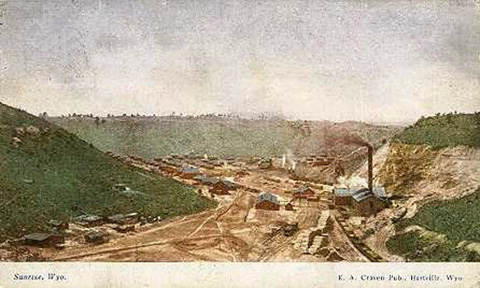
Just east of Hartville, copper deposits were discovered and the Sunrise Mine was established around the same time—and named for the good view the spot offered out to the east and the rising sun.
By the late 1880s the copper prospects were dwindling, and miners turned to iron ore, which would prove far more lucrative. In 1898, the Colorado Fuel and Iron Company, part of the widespread iron and steel interests of John D. Rockefeller, acquired the Sunrise Mine as an iron-ore prospect, and began building a company town there in 1899.
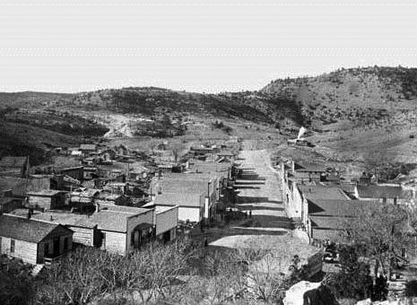
The company owned everything in the town—the store, the miners’ four-room houses, a boarding house and a social hall. Nearby Hartville was not owned by the company and remained a rougher place, as it offered saloons to the people of Sunrise. Miners and their families from Greece, Italy, England, Japan, Lebanon, the Scandinavian countries and many more settled in Hartville and Sunrise. Some started businesses in Hartville and stayed to become established members of the communities.
At its peak of operations, the Sunrise Mine employed 700 workers and extracted thousands of tons of ore per year. The mine closed in 1980, and the town was abandoned. Many foundations and some of the buildings remain.
In 1900, meanwhile, the Burlington Railroad, building west up the North Platte River from Nebraska, entered Wyoming. In 1902, the railroad’s land company established the town of Guernsey, on the river five miles south of Hartville, near a pair of famous landmarks on the old Oregon Trail—Register Cliff and the Oregon Trail Ruts. Guernsey quickly prospered as a shipping point, where the rail spur to the mines joined the Burlington line.
Platte County named for the river
Growing populations in Wheatland and the Guernsey-Hartville-Sunrise area led the Legislature to create a new county out of the northwestern parts of Laramie County in 1911. Gov. Joseph M. Carey signed the bill establishing the county on Feb. 9, 1911. Organizing commissioners Chris Hauf of Glendo, T.J. Carrol of Wheatland and Robert Grand Jr. of Chugwater first met on March 8, local voters approved the idea in November 1912 and the county government was finally organized on Jan. 7, 1913.
Platte County is bordered on the northeast by Niobrara County; on the east by Goshen County; on the south by Laramie County; on the west by Albany County; and on the northwest by Converse County. Platte County includes five towns: Chugwater, Glendo, Guernsey, Hartville and Wheatland. Smaller, census-designated places are Chugcreek, Lakeview North, Slater, Westview Circle, Y-O Ranch, Whiting and Sunrise.
The county was named for the North Platte River. In the 1790s, French fur traders and trappers named the river “Platte,” from the French for “flat” or “shallow.” The river to this day is the lifeblood of the area, providing water to more than 335,000 acres in Wyoming and Nebraska, enabling the semi-arid plains to produce alfalfa, corn, potatoes, sugar beets and dry beans.
Irrigation and dams
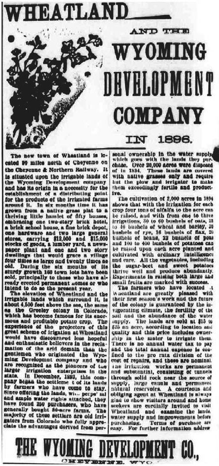
Local lore credits Cheyenne-based politician and Judge Joseph M. Carey, later Wyoming’s U.S. senator and governor, businessman Andrew Gilchrist and poet Johnny Gordon with turning cactus-covered prairie into a valuable irrigation district. In 1878, Carey and Gordon brainstormed about an irrigation project to divert water from the Laramie River to Blue Grass and Sybille creeks and onto the Wheatland Flats and planned canals to take water to specific farmlands.
Wheatland Flats, around present-day Wheatland, Wyo., covers about 20 miles between the Laramie Mountains on the west and Chugwater Creek on the east and extends about 22 miles from the Laramie River on north to the Richeau Hills to south.
Carey organized a committee for the project and finalized plans in the winter of 1882. Work began a few months later. In 1883, the Wyoming Development Company was formed to oversee construction and officials of the company also allocated water rights. Other investors included Francis E. Warren, later governor and U.S. senator, and ranchers William Irvine and Horace Plunkett. In 1884, farmers began settling on lands in this irrigation district. The Cheyenne and Northern Railway, building north from Cheyenne, reached the Wheatland Flats area in 1887. By 1897, water stored in reservoirs in north-central Albany County and then piped to the Flats provided added irrigation.
The development caused an upsurge of settlement. Lots were sold in the new town of Wheatland in 1894, and it was finally incorporated in 1905. When Platte County was formed in 1911, Wheatland was chosen as county seat. As Wyoming water law continued to evolve, the Wyoming Development Company eventually became the Wheatland Irrigation District, a public board still administering irrigation projects in Platte County.
As Platte County moved into the 20th century, the need for more irrigation water led to construction of two important dams on the North Platte River at the northern end of the county.
In 1902, President Theodore Roosevelt signed the Reclamation Act to fund irrigation on federal lands in the American West. Pathfinder Dam, on the North Platte 100 miles upstream from Platte County, was completed in 1909.
That same year, the U.S. Senate Committee on Irrigation and Reclamation came to Wyoming on a fact-finding mission. State Sen. Charles Guernsey, for whom the town of Guernsey was named, advocated for a site on the North Platte River for its capacity for water storage and its potential for production of electric power. He successfully persuaded committee members to look at his Guernsey site. Their enthusiasm eventually led to congressional authorization for the project, which became known as the Guernsey Dam.
Construction on the dam finally began in the summer of 1925 and was finished by 1927. The dam’s purpose was to better control storage water released from Pathfinder and to stanch excess flow of North Platte tributaries that entered the river below Pathfinder.
The reservoir had a storage capacity of 74,264 acre-feet of water, and the power plant contained two 3,000-kilowatt generators. Stilting, by which sediment dropped by a slowing river gradually fills a reservoir, steadily decreased the storage capacity, but the power-producing capacity of the dam has greatly increased over time.
Lake Guernsey State Park around the reservoir was a joint endeavor by the Bureau of Reclamation, National Park Service and Civilian Conservation Corps. Members of the CCC, a work program for men aged 18-25, established camps around Guernsey Dam in May 1934. They built roads, a scenic overlook, bridges, picnic shelters, water fountains, trails and a museum. The park, designated a National Historic Landmark in 1997, has become well known as a prototype for recreation areas around Western reservoirs.
Early disputes over water rights to rivers illustrated how valuable the flowing waters were. Wyoming and its downstream neighbor, Nebraska, both claimed water in the North Platte River. After considerable legal wrangling occurred, the U.S. Supreme Court ruled in 1945 that Nebraska was entitled to 75 percent of the river's water and Wyoming 25 percent.
The Guernsey Reservoir's loss of capacity due to stilting gave rise to the need for another holding site to be built, and in 1944, investigations began into a site near Glendo, 25 miles upstream from Guernsey Reservoir. Legal decrees and agreements flowed and mixed like the water they were regulating, and a decade passed before construction began.
Construction on Glendo Dam began late in 1954, and Glendo Reservoir was designated as an 800,000 acre-foot holding site. Within that capacity, 100,000 acre-feet were to be used for irrigation; 115,000 acre-feet for sediment control; 275,000 acre-feet for flood control; and 310,000 acre-feet for power production. An acre-foot is the volume of water sufficient to cover an acre of land to the depth of one foot.
Meanwhile, Congress amended its earlier action involving Wyoming and Nebraska's water rights. In the amendment, annual water usage of the stored 100,000 acre-feet was divided into 15,000 acre-feet for Wyoming and 25,000 for Nebraska. The increased output of hydroelectric power would continue to serve both states as well as Colorado.
Construction was competed in the fall of 1957. The project included a 2,100-foot long earthen dam, a storage reservoir with a capacity of 798,440 acre-feet and a 24,000-kilowatt capacity power plant. Glendo State Park, similar to Lake Guernsey State Park before it, was developed in the 1960s and has become a popular recreation area.
The final development involving Platte County’s water supply was the Laramie River Station of the Missouri Basin Power Project, which was built just east of Wheatland on the Laramie River. Construction of the power plant began in 1974 and by July 1, 1980, the first coal-fired unit was finished and producing electric power. The station’s three coal-fired units were completed by1982.
The same project also involved construction of the Grayrocks Dam, 11 miles east of the Laramie River Power Station. Conservation groups protested at the time, arguing construction would harm wildlife along the river, especially the whooping crane population downstream from the dam. In December 1978, the Department of the Interior determined that the crane population and the reservoir construction could coexist, and the company and the conservationists negotiated a settlement whereby the company set up a $7.5 million trust fund for habitat improvement in Wyoming and Nebraska.
The eight-mile-long Grayrocks Reservoir behind the dam now provides several species of game fish for anglers—and water for the power plant. There are also recreational facilities and a visitor overlook near the reservoir.
Platte County today
Still important to the economy of northern Platte County is the Wyoming National Guard training camp at Guernsey, established near the town in 1939, shortly before the outbreak of World War II.
Camp Guernsey has grown substantially in recent decades and now covers more than 77,000 acres east, south and west of the town. Guard and other army units train there regularly. The camp can house up to 1,500 soldiers at a time. Its rocky landscapes and arid climate make it useful for training troops headed for deployments in the Middle East. The camp also allows grazing, hiking, hunting and recreational activities on its land.
Today, ranching and farming remain vital to the area, as do recreation, tourism, electric power production, and management and control, throughout Platte County, of the tributaries of the North Platte River, and of the river itself.
Resources
- Basin Electric Power Cooperative. "Laramie River Station." Accessed Jan. 15, 2013, at http://www.basinelectric.com/Electricity/Generation/Laramie_River_Statio....
- “Camp Guernsey, Wyoming: A Premier Joint Training Center.” Wyoming Military Department, accessed March 6, 2013 at https://www.wy.ngb.army.mil/guernsey/Default.asp.
- “Cheyenne Indian History,” from Handbook of American Indians North of Mexico, Frederick Webb Hodge, 1906, Bureau of Ethnology, Government Printing Office. Accessed Feb. 19, 2013 at http://www.accessgenealogy.com/native/tribes/cheyenne/cheyennehist.htm.
- Donahue, Jim, ed. "Administrative History of Platte County." In Wyoming Blue Book. Vol. 5, pt. 1. Cheyenne, Wyo.: Wyoming State Archives, 1991, 600-606.
- Fuglelberg, Jeremy. "Camp Guernsey in Wyoming helps serve military's training needs in post-Sept. 11 world." Casper Star-Tribune, Sept. 9, 2011, accessed Feb. 27, 2013, at http://trib.com/special-section/sept11/camp-guernsey-in-wyoming-helps-serve-military-s-training-needs/article_01a54353-6aab-51e1-8288-a7a8d2e3dcd7.html.
- “The Grayrocks Dam Conflict.” Learning from Experience, a website of natural resource collaboration and partnership case studies and lessons, University of Michigan case study # 8, accessed March 1, 2013 at http://www.snre.umich.edu/ecomgt/cases/pubs/acus/The_Grayrocks_Dam_Conflict.pdf.
- National Park Service. "Glendo Dam, Wyoming." Accessed Jan. 15, 2013, at http://www.cr.nps.gov/nr/travel/ReclamationDamsAndWaterProjects/Glendo_D....
- __________________. "Guernsey Dam, Wyoming.”Accessed Jan. 15, 2013, at http://www.cr.nps.gov/nr/travel/ReclamationDamsAndWaterProjects/Guernsey....
- Platte County Extension Homemakers Council. Wyoming Platte County Heritage. Marceline, Mo.: Walsworth Publishing, 1981, 1-37.
- “Sunrise Mine Historic District.” National Register of Historic Places registration form, accessed Feb. 24, 2013 at http://pdfhost.focus.nps.gov/docs/NRHP/Text/05000925.pdf.
- Talbott, Starley. Images of America: Platte County. Mount Pleasant, S.C.: Arcadia Publishing, 2009, 1-8, 34-35, 62, 71, 76, 98-107, 125.
For Further Reading
- For much more on Guernsey State Park and the Civilian Conservation Corps work there, including architects’ plans and photos of camp life and construction, visit the Wyoming State Historical Preservation Office’s website on the subject.
Illustrations
- The photo of the lightning storm is by Chance Kaka, from Panoramio. Used with thanks.
- The ad for Wheatland from the July 14, 1896 Wyoming Tribune is from Wyoming Places. Used with thanks.
- The 1909 postcard of Sunrise is from Wyoming Tales and Trails. Used with thanks.
- The 1902 photo of Hartville is from the Wyoming State Archives, via Wyoming Places. Used with thanks.
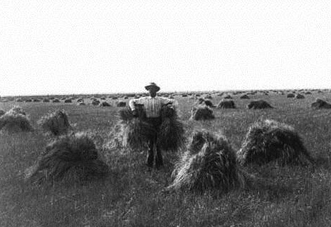
- The L.E. Stimson photo of wheat stacks on the Braden Farm near Wheatland in 1909 is from the Wyoming State Archives, by way of Wyoming Places. Used with thanks.
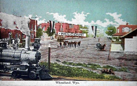
- The 1910 color postcard of downtown Wheatland is from Wyoming Tales and Trails. Used with thanks.
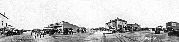
- The 1922 panorama of downtown Glendo is from the Wyoming State Archives, by way of Wyoming Places. Used with thanks.
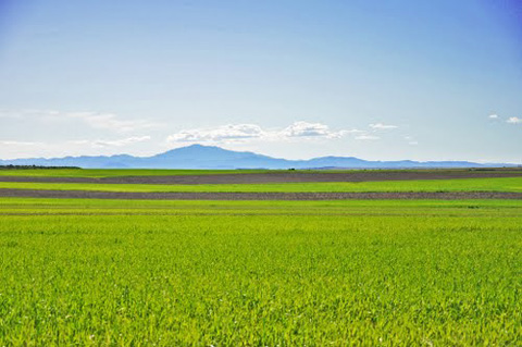
- The photo looking west at Laramie Peak, with green fields in the foreground is by Chance Kaka, from Panoramio. Used with thanks.