Uinta County, Wyoming
Uinta County lies in the southwestern corner of Wyoming. Formed in 1869 as one of the five counties of Wyoming Territory, Uinta County originally stretched from Utah to Montana. In 1911, it was reduced to its present size, when Lincoln County was carved from Uinta County’s northern reaches.
Geographically, Uinta County encompasses two separate watersheds: the Bear River and the Black's Fork of the Green River. They are separated by a series of low mountain ranges known throughout the state as the Three Sisters; their local name is simply the Divide.
Evanston, the county seat, along with the Town of Bear River, lie in the Bear River Valley. The communities of Fort Bridger, Mountain View and Lyman are the major population centers in the eastern part of the county, in the drainage of the Black’s Fork of the Green River, which is known as the Bridger Valley.
The county was named for the Uinta Mountains to the south. The name itself is said to mean pine tree or pine forest. The American Indians who made this part of Wyoming their seasonal home were primarily Eastern Shoshone, along bands of the with Ute and Bannock tribes. Some families in the county still tell stories of their grandparents and great-grandparents seeing Indian encampments on the hills west of Evanston during the annual migrations of the Shoshone through the area.
Trappers
The first whites to enter the area of present-day Uinta County were fur trappers in the first decades of the 19th century. Henry's Fork and the Black's Fork of the Green River-- both major streams in the eastern part of the county--were named for Andrew Henry, William Ashley's partner in the Rocky Mountain Fur Company, and Daniel Black, another member of the organization. The first Rocky Mountain fur trade rendezvous, created by Ashley, was held in June 1825 beside Henry's Fork in what’s now the far southeastern corner of the county.
Other fur trappers, including John Robertson and Jim Bridger, became permanent residents of the county. Robertson, known locally as Jack Robinson or Uncle Jack, built a cabin on the Black's Fork in 1834. The small community of Robertson in the Bridger Valley still bears his name.
From the mid-19th century to the present, the history of Uinta County has been shaped by four major economic forces: trails, rails, ranches and resources.
Trails
The great American overland migration of the mid-19th century created a braid of trails across Wyoming—the Oregon, California and Mormon trails. In the early 1860s, another more southerly route was established, used by stage companies along with emigrant wagon trains. Eventually, the transcontinental railroad, the Lincoln Highway and, ultimately, Interstate 80 followed this southerly route. All of these trails and routes passed through what’s now Uinta County.
The Oregon Trail originally traversed the Black's Fork Valley before heading north toward Fort Hall, Idaho. In 1843, fur trapper Jim Bridger set up a trading post on the Black's Fork to serve travelers on the Oregon Trail and later the Mormon, California, Cherokee Trails. At Bridger’s Fort, travelers could trade their weakened animals for rested ones and obtain needed food and other supplies. In 1855, Bridger and his partner, Louis Vasquez, sold Bridger's Fort to the Mormons who were operating Fort Supply a few miles to the south to serve emigrants on the Mormon Trail. In 1857, Mormon militia burned Bridger’s Fort to prevent its capture by the U.S. Army in the so-called Utah War. In 1858, the Army took possession of the post and renamed it Fort Bridger. The fort remained an army post until 1890 when it was abandoned.
By the early 1860s, conflicts between emigrants on the Oregon-Mormon-California Trails and native tribes led the government to establish a new trail through Colorado and Wyoming known as the Overland Trail. The Overland Trail, which had been mapped by Howard Stansbury of the U.S. Corps of Topographical Engineers in 1851, ran through southern Wyoming. Ben Holladay, who carried the U.S. mail on his Overland Stage Company, began using this route in July 1861. The western portion of the Overland Trail through Wyoming passed through Fort Bridger.
Rails
In 1868, the Union Pacific Railroad entered Uinta County along the route of the Overland Trail, laying tracks that passed a few miles north of Fort Bridger, then south, crossing the Aspen Hill summit before turning north along the Bear River.
As elsewhere during railroad construction, temporary camps and end-of-the-tracks towns sprang up in Uinta County. The most notorious was Bear River City, also known as Beartown. In November 1868, it was the site of a violent vigilante riot, during which the shantytown was burned and the printing press of the Frontier Index, the newspaper chronicling the construction of the railroad, was destroyed.
Another end-of-tracks town, Piedmont, was a site of a labor strike in early May 1869. Workers held up the special train carrying UP Vice President Thomas Durant, traveling to the golden spike ceremony to mark completion of the transcontinental railroad in Utah Territory, and demanded payment of back wages. A hastily composed telegram produced the results the workers wanted, and a day and a half later, they allowed the train to pass through.
Of the temporary camps, Carter, Piedmont and Evanston evolved into permanent settlements. Carter, named for Judge William Carter who served for many years as sutler at Fort Bridger, became a major shipping point on the railroad for sheep and cattle in the Bridger Valley. Piedmont was a service point for locomotives on the long grade between Carter and Evanston until the completion of the Aspen Tunnel in 1901 allowed the tracks to bypass it.
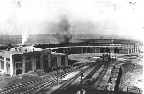
Evanston was established in November 1868, and named after James A. Evans, the UP surveyor who surveyed the eastern half of the line through what’s now Wyoming. The town’s streets were platted by UP chief engineer, Grenville Dodge. Dodge, ever the railroad man, laid the streets out parallel with the tracks rather than on a north-south orientation. The stone roundhouse, built in 1871, was replaced in 1912 with a 28-stall brick roundhouse. That structure, the last surviving full roundhouse on the original UP-Central Pacific line between Omaha and Sacramento, is now a National Landmark and is being renovated for community use.
The county seat, Evanston became a division point on the railroad between Ogden, Utah, and Green River in 1870 and the largest community in the county.
In the first decade of the 20th century, yet another transcontinental route passed through Uinta County as automobilists attempted to cross the continent by car. In March 1908, the Great Automobile Race from New York to Paris brought six automobiles through the county. By 1913, the Lincoln Highway, a route comprising existing roads and trails between New York City and San Francisco, became the nation's first transcontinental automobile route. Like the 19th century trails, it traversed Uinta County. The route became the basis for U.S. Highway 30 and, eventually, I-80 through this part of Wyoming.
Ranches
John Myers established the first ranch in the Bear River drainage in 1858 and filed the first water right in what became Wyoming Territory. The Myers ranch, still operated by family members, is located where the Mormon Trail crossed the Bear River south of present-day Evanston.
After the railroad was completed in 1869, cattle and sheep ranching developed quickly throughout the county. Stock grazed in the high meadows of the Uinta Mountains in the summer and fed on locally grown hay in the winter. While many of the railroad section camps throughout the county had small corrals, the largest shipping point for livestock in the Bridger Valley developed at Carter. Ranchers in the Bridger Valley also raised hay and some grain crops. Beginning in the 1890s, extensive irrigation canals and ditches were built to aid their efforts.
Between 1880 and 1900, the population of the county grew quickly. The 1880 census showed 28 farms in Uinta County. A post office was established at Mountain View in the Bridger Valley 1891. In 1899, Lyman was founded nearby as a Mormon agricultural colony. Other, smaller communities sprang up where ranchers took up homesteads along the Henry's Fork and Smith's Fork Rivers.
By 1900, the number of farms had grown to 940, with the census showing 13,600 horses, 125,000 cattle and 914,000 sheep--the largest number in any Wyoming county. In 1915, the University of Wyoming established a 200-acre experimental farm in the Bridger Valley just east of Lyman. The most recent agricultural census in 2007 counted 344 farms in Uinta County, listing 44,500 cattle and 41,200 sheep. Livestock ranching continues to be an important part of the county's economy.
Natural Resources
One of the inducements for the Union Pacific to build its tracks through what’s now Wyoming was the presence of large tracts of coal along its right of way. By the late 1860s, coal was being extracted from a series of mines dug into a ridge above the Bear River north of Evanston. The community that sprang up around these mines was called Almy. In addition to the white miners, many others were Chinese, brought to the area by labor contractors for the Union Pacific Coal Company. After a series of disastrous mine explosions in the 1880s and 1890s in which dozens of white and Chinese miners were killed, the Almy mines were permanently closed by 1900.
A smaller coal camp was established southeast of Evanston in Spring Valley about the same time as the Almy mines were closing. But in 1904, the focus at that camp shifted quickly when a well being drilled to provide water produced oil instead. The Spring Valley oil boom lasted just a few years before the shallow wells played out.
In the early 1970s, high oil prices resulting from an oil embargo and national gasoline shortages spurred more exploration for oil. The result was a boom in oil and natural gas drilling in Uinta County along the Overthrust Belt along the western side of the county in the late 1970s and early 1980s.
The boom brought thousands of people—mainly young, unmarried construction and oilfield workers—into the county. Between 1970 and 1980 the county’s population nearly doubled from 7,100 to more than 13,000. New housing developments and trailer parks sprang up like mushrooms. Law enforcement and health care resources were stretched beyond their limits.
One of Wyoming's most notorious and complex criminal cases epitomizes the wild atmosphere in Uinta County during the boom. Mark Hopkinson, a Bridger Valley resident, became embroiled in a dispute that involved Evanston attorney Vincent Vehar. Hopkinson hired a friend of his to bomb the Vehar home in August 1977. The explosion killed Vehar and two members of his family. Eventually, Hopkinson was convicted of murdering the Vehars and for ordering the murders of two other people, and was executed at the state prison at Rawlins, Wyo. in January 1992.
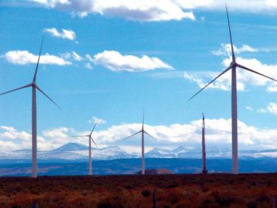
Residents still shudder at the violence of that period, but the oil boom had positive effects as well. The boom generated millions of dollars in severance tax and other revenues, which county officials invested in infrastructure and public facilities such as schools and hospitals. By 1990, the population had reached 18,700. Even though the boom was well over by that time, the county's population continued to increase, reaching 21,000 in the 2010 census. As oil and gas production declined somewhat in the 2000s, groups of large wind turbines were established on the Divide and on Bridger Butte, tapping into yet another abundant energy resource.
Clarence D. Clark
At least one Uinta County resident achieved fame beyond far the county line. Clarence Don Clark, a Union Pacific Railroad lawyer, was elected the first U.S. congressional representative from the new state of Wyoming in 1890. Clark later served four terms as U.S. Senator from Wyoming.
Continuity
Aside from economic booms and busts, the history of Uinta County reveals more subtle continuity than abrupt change. One constant has been the presence of the Wyoming State Hospital. Originally the Wyoming Insane Asylum, the hospital was established in 1887 by the Territorial Legislature on a 100-acre plot of land just south of downtown Evanston. The hospital, which opened in 1891, continues to serve the entire state, and has offered a steady source of employment for local residents. At present, the Hospital employs around 250 people and serves more than 100 patients.
The schools in the county also provide a sense of continuity and community identity, as well as a significant source of employment within the county. Currently there are three school districts in Uinta County headquartered in Evanston, Lyman and Mountain View.
Another constant has been the Union Pacific Railroad Company, consistently a major employer in the county since the 1870s.
Finally, historic preservation efforts--both public and private -- have transformed decaying downtown buildings into vital commercial space and abandoned railroad properties into community events centers, ensuring that the past continues to serve a useful purpose in the present.
Resources
- Bogart, Barbara Allen and the Uinta County Museum. Images of America: Evanston. Charleston, S.C.: Arcadia Publishing Co., 2009.
- Donahue, Jim, ed., Wyoming Blue Book. Cheyenne: Wyoming State Archives, Department of Commerce, 1991, vol. V, part I. “Administrative History of Uinta County,” pp. 749-758.
- Ellison, Robert Spurrier. Fort Bridger, Wyoming: A Brief History, 2nd printing, revised and enlarged. Cheyenne: Historic Landmark Commission of Wyoming, 1938.
- Evanston Historic Preservation Commission. Evanston's Railroad Complex. Park City, UT: Main Frame, 1998. Videocassette.
- Evanston Historic Preservation Commission. The Chinese in Evanston, Wyoming. Evanston, Wyo., 1995 (?).
- Gardner, A. Dudley and Verla R. Flores. Forgotten Frontier: A History of Wyoming Coal Mining. Boulder: Westview Press, 1989.
- Hamblin, Kathaleen K. Bridger Valley: A Guide to the Past. Mountain View, Wyo.: K. K. Hamblin, 1993.
- Huseas, Marion McMillan. Legacy of Fear: Mark Hopkinson and the Bridger Valley Murders. Cheyenne: Merrimac Publishing Company, 2006.
- Jones, Walter. Derricks and Determination: Oil Exploration in a Portion of Southwestern Wyoming, 1847-1982. Casper: Mountain Lithography Company, 2005.
- Lester, Margaret M. From Rags to Riches: A History of Hilliard and Bear River, 1890-1990. Evanston, Wyo.: First Impressions, 1992.
- Rufi, Sharon Fearn and the Almy Centennial Committee. Almy Centennial History Book. Privately published, 1990.
- Stone, Elizabeth Arnold. Uinta County, Its Place in History. Laramie, Wyo.: Laramie Printing Company, 1924.
- Tippets, Susan T. Piedmont, Uinta County, Wyoming, A Ghost Town. Privately published, 1995.
- Union Pacific Coal Company. History of the Union Pacific Coal Mines, 1868 to 1940. Omaha, Neb.: Colonial Press, 1940.
- Union Pacific Railroad Company. Plat Map of Evanston, Wyoming. June 30, 1970. As of 2012, the original hangs in the office of Evanston’s city engineer.
Illustrations
- The recent photo of a restored portion of the Union Pacific roundhouse, with the machine shop in the background, is from the Evanston Chamber of Commerce. Used with permission and thanks.
- The black-and-white aerial photo of the UP roundhouse dates to about 1920 and is from the collection of the Uinta County Museum. Used with permission and thanks.
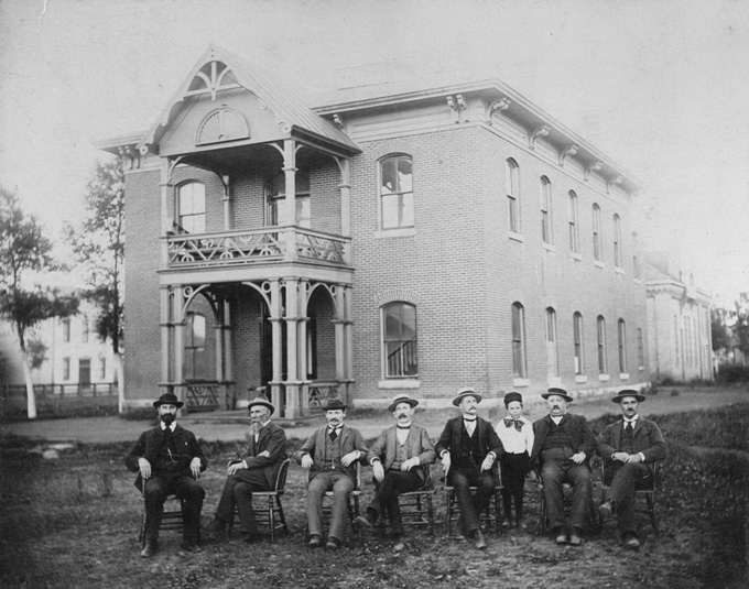
- The photo of the Uinta County Courthouse shows a group called locally “the Ring Superior,” but only James Edward Burdett at far left is identified. The courthouse was built in 1874 and is the oldest functioning courthouse in the state. Joseph E. Stimson photo, about 1900. Wyoming State Archives, via the Uinta County Museum. Used with thanks
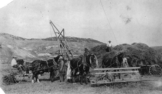
- The undated photo of the haying operation near Almy shows, left to right, Abe Salmela, his brother-in-law Oscar Huhtala, Eino Salmela, Hihla Salmela (wife of Eino), Bill Salmela (head just visible behind the horse). Another man, unidentified, is also behind the horse and Oscar Piirainen is on the haystack. Uinta County Museum, used with permission and thanks.
- The photo of the wind turbines on Bridger Butte, with the Uinta Mountains in the background, is by Jeff Gearino, from the Casper Star-Tribune May 13, 2008. Used with thanks.