Natrona County, Wyoming
Natrona County lies at the intersection of the basins, mountains and great plains of Wyoming that remain after billions of years of geological change. Here, water and wind have exposed rock layers, creating a dramatic landscape. Red outcroppings of sandstone vie with white limestone and variegated granites. Distinctive land features include Casper Mountain, Independence Rock, the Red Buttes, Devil’s Gate and Teapot Rock.
Much of the county holds buried treasures of oil and natural gas. More visible are outcrops of coal, remains of primordial swamps. Early-day prospectors also exploited deposits of copper, trona and asbestos.
This is an arid environment averaging ten inches of moisture per year, but few years are average. The mountains, such as Casper Mountain, receive considerably more moisture, usually in late winter snow storms. Run-off in the early summer can lead to flooding of the North Platte and Sweetwater rivers as well as smaller tributaries. Only man-made reservoirs prevent wholesale damage downstream.
Ancient nomads traveled through and lived in the area that would later become the county between 12,000 and 9,000 years ago. These people traveled during the warmer seasons and then settled in sheltered areas for the winter. They hunted big game like bison antiquus aaaaaand columbian and woolly mammoths, as well as smaller animals, and gathered edible plant materials such as berries and seeds.
Archaeologists have excavated a number of areas in Natrona County, mostly bison kill and butchering sites. A dig conducted in 2006 by local archeo-geologist John Albanese at Hell’s Half Acre, west of Casper, Wyo. found spear points and other materials that dated from 3,000 to 1,200 years ago. In 1971, Wyoming State Archaeologist George Frison excavated a bison kill site west of Casper, on the north bank of the North Platte River. The site dated from 10,000 to 9,500 years ago.
More recent Indian groups, including the Lakota, Northern Cheyenne, Arapaho, Crow and Shoshone tribes migrated through and occasionally wintered in the county, beginning in the 1700s. Their lives came under increasing pressure after the arrival of Euro Americans. By the late 1800s, the U.S. government required most tribes to settle on reservations. Even so, bands of Lakota and Shoshone traveled through the county into the 1890s.
Many early European explorers came through Wyoming, among them Robert Stuart and his companions, who traveled east from Fort Astoria on the Pacific coast in 1812. History credits Stuart with recording the first European travel west to east on what became known as the Oregon Trail. A later explorer and mapmaker, John C. Frémont, nicknamed ”The Pathfinder,” gave the North Platte’s modern-day Pathfinder Dam and Reservoir their name. Photographer William Henry Jackson, who traveled with mapmaker Ferdinand Hayden, documented his travels through present‑day Natrona County in photographs and paintings.
In the mid-19th century, the North Platte and Sweetwater rivers became the route for numerous travelers moving to Oregon, California or the valley of the Great Salt Lake. The Oregon/California/Mormon Trail followed the river upstream from Nebraska, allowing emigrants to follow a clear path west.
Dangerous river crossings prompted entrepreneurs to construct ferries and bridges from what is now Douglas, Wyoming west into the Sweetwater country. The Archambault brothers and Charles Lajeunesse ran the Sweetwater bridges in the 1850s. First the Mormons ran a ferry just west of Casper, near present-day Mills, and then Louis Guinard established a bridge nearby. John Richard operated a series of bridges, the most notable being the one at what’s now Evansville,Wyo., east of Casper.
Beginning in the 1850s, the U.S. Army posted troops along the river to protect travelers at the crossings and later to defend the new telegraph line connecting the eastern states and California. In 1865, two famous battles between Indians and soldiers occurred in what is now Natrona County near an army post built at Guinard’s bridge. During the Battle of Platte Bridge Station on July 25, 1865, Cheyenne and Lakota warriors killed numerous soldiers including Lieutenant Caspar Collins. On the same day, more Indians attacked Sergeant Amos Custard and his small supply train a few miles to the west. In honor of Collins, the Army designated the post as Fort Casper, misspelling his name in the process. In 1888, the town of Casper, soon to be the county seat of Natrona County, also took Collins’s misspelled name.
Some of the earliest businesses in the county were cattle and sheep operations. Joseph Carey and his brother controlled much of the west side of the county including parts of what later became Casper. Joseph Carey later became a U.S. senator and Wyoming governor. Bryant B. Brooks, another land baron who invested in cattle and sheep, was also elected Wyoming governor. Texas rancher Gilbert Searight established the Goose Egg Ranch near Bessemer, west of Casper. The Goose Egg ranch house was a hotel, restaurant and possibly used as the setting for part of Owen Wister’s novel, The Virginian. Searight sold out to the Carey Brothers in time to avoid the horrible winter of 1886-1887.
Out in the Sweetwater country the biggest ranchers were Tom Sun, Bonaparte “Boney” Earnest, Albert and John Bothwell, and Tom and John Durbin. Perhaps the most notorious incident in that part of the county was the hanging of James Averell and Ellen Watson on July 20, 1889, by vigilantes Tom Sun, John Durbin, Albert Bothwell, Robert Conner, Robert Galbraith and Ernest McLean. A grand jury failed to bring charges against the men. Publicity, almost certainly engineered by the vigilantes, branded Watson as Cattle Kate, a notorious rustler, tarring her reputation until new research turned up the real story, clearing her name, in the 1990s.
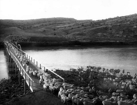
In addition to the owners of large parcels of land were numerous smaller ranchers; some raised cattle and somer raised sheep. Sheep began appearing on the ranges mostly in the northern and western parts of the county in the 1880s, but sheep ranching was not a big part of the economy until the 1890s. Many of the sheepmen were Irish immigrants and some of them, too, eventually controlled large acreages of land.
But as sheep numbers rose in the 1890s, and numbers of cattle gradually declined, tensions between cattlemen and sheep ranchers led to violence over who would get to use the open range. Particularly in northern Wyoming, some cattlemen tried to eliminate their competition, killing entire bands of sheep and sometimes sheepherders. In 1909, the peak year for sheep, there were around 6 million in Wyoming, and only about a seventh as many cattle. Cattle-sheep ratios were probably similar in Natrona County. In the early 1910s, tensions between cattle and sheep raisers finally began to decrease.
As towns sprang up in the late 1880s, residents began seeking a county government with the infant town of Casper at the center of this effort. In 1890, Territorial Governor Francis E. Warren signed legislation splitting Carbon County in two with the north half becoming Natrona County. Casper and Bessemer, ten miles farther up the North Platte, vied for the plum title of county seat. Bessemer got more votes, but the number was so much larger than the hamlet’s actual population that election officials declared the returns fraudulent, and Casper won the election, ensuring its survival and leading to Bessemer’s demise.
Casper in 1890 was hardly an upscale community. Most buildings were wood, but the addition of new government buildings constructed of sturdy brick led to reconstruction and expansion of business blocks in brick and stone. The Fremont, Elkhorn and Missouri Valley Railroad and later the Burlington Northern made the town into a supply and distribution hub. Other towns began to grow as ranching and oil discoveries drew people to the far reaches of the county.
Along with government and business infrastructure, houses, schools and churches made the towns good places to live and raise families. Newspapers competed aggressively for readers while detailing all of the comings and goings of residents and businessmen. Alfred Mokler, who arrived in 1897 to run the Natrona County Tribune, became an influential local opinion-maker. When he wrote his opinionated, but mostly factual History of Natrona County, Wyoming, 1888-1922 in 1923, he also became the official chronicler of the county’s past.
Little did people realize the immense changes that were coming their way when Cyrus Iba filed for the first oil lease in the county in the early 1880s. Beginning in the 1890s, scores of investors began to converge on Casper and by the turn of the century, test wells were common in the area. Mark Shannon created the Pennsylvania Oil and Gas Company in 1888 to exploit possible oil properties in the Wyoming fields.
Transportation problems and the need for a local refinery hampered early efforts, but soon Pennsylvania Oil and Gas built a refinery in Casper. French and Belgian investors also set up operations, but it was the Midwest Oil Company in 1910 that began the first really big development. John D. Rockefeller’s Standard Oil was a latecomer. By the end of the 1920s, he had bought out most of the competition.
Around the same time, federal funds first came to the county in a substantial way with the construction of Pathfinder Dam on the North Platte River in Fremont Canyon, near the southern border of Natrona County. The U.S. Reclamation Service built the dam to store water for irriagation. Freight and supplies were shipped 50 miles out from Casper by mule train. The dam was completed in 1911.
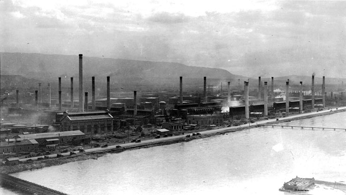
In the 1910s and 1920s, the Salt Creek oil patch at the northern end of Natrona County was the largest production field in the world. This drew thousands of workers and their families, most of the men veterans of World War I, to Casper and the small towns that cropped up in the oil district. Salt Creek (later renamed Midwest), Edgerton, Lavoye and Snyder were just a few of the towns that arose almost over night. Edgerton and Midwest were the only towns to survive.
The Great Depression arrived in most of the nation after the stock-market crash of 1929. But economic difficulties hit Wyoming’s oil industry years earlier, in 1926. As prices and demand dropped, Natrona County experienced its first energy bust, and many people left.
After President Franklin Roosevelt took office in 1933, New Deal programs brought much- needed money and jobs into the county. Civilian Conservation Corps workers helped build roads and ski slopes on Casper Mountain. Works Project Administration and Public Works Administration money contributed to the construction of a replica of Fort Casper on its original site, a new post office and federal building downtown and provided funds for Alcova Dam, a U.S. Bureau of Reclamation project 30 miles upstream on the North Platte.
World War II, which began for the United States on December 7, 1941, finally brought the country out of the Depression and took hundreds of thousands of young men and women off to war. The war also brought the Casper Army Air Base to what is now the Natrona County International Airport. The base provided jobs for locals and introduced flyers-in-training to Wyoming hospitality.
After the war, many veterans returned to the state. They started families, found jobs and readjusted to their postwar lives. Natrona County’s population grew by more than 30 percent, from 23,858 to 31,437, between 1940 and 1950. In the following decade, population increased another 57 percent, reaching 49,623.

This was the time of television, and growing families and towns. Casper College opened for its first students in 1945, and a decade later was building a modern campus south of town on “C” Hill. This two-year college offered returning veterans an opportunity to begin their college educations paid for by the G.I. Bill.
From 1945 into the early 1970s was an era of optimism. Modern oilmen Dave True, Neil McMurry, Fred Goodstein, Tom Stroock and John Wold all began or expanded their operations during this time. The economic boom allowed these men and others to make fortunes in oil, real estate, construction and ranching. Casper was also a center in these years for the uranium business with offices of companies operating mines in nearby Carbon and Fremont counties. In spite of the prosperity, the population grew slowly in the 1960s. The census of 1970 recorded an additional 1,641 people, bringing the total up just 3.3 percent to 51,264.
Casper continued as the region’s hub, offering retail, medical and other services. In Casper and other communities, town leaders used tax revenues to pave streets, build sewer systems and provide a good water supply. Veterans Administration loans assisted veterans in buying many new houses.
Recreation and entertainment added to the quality of life. Casper had a symphony, movie theaters and beginning in 1957, the Casper Troopers, a drum and bugle corps that competed nationally. Ski enthusiasts enjoyed fresh powder on a few small ski slopes on Casper Mountain. The largest was Hogadon Basin Ski Area, which opened in 1959, and is still in use today, operated by the City of Casper. Many people also took advantage of the recreational opportunities at Alcova and Pathfinder Reservoirs.
Some of the luster ended when an economic bust in 1973 marked the end of the age of refineries and big oil production in Natrona County. Increasingly, oil came from other parts of the world but new types of oil drilling as well as an emphasis on natural gas eventually revived the county’s economy. Producers started shipping petroleum out by pipeline. The 1980 census showed 20,592 more residents than in 1970, a 40 percent increase that brought the total population to 71,856.
The most recent era of Natrona County’s history, between 1980 and 2011, showed some significant changes. Another energy bust in the 1980s led many of the larger oil companies to close their Casper offices, and forced local producers to diversify. Population fell. In addition to drilling, supplying equipment and workers kept companies afloat. The drilling supply business picked up again in the 1990s, with a boom in coal-bed methane production in the Powder River Basin to the north and east.
Cultural organizations continued to evolve. The Nicolaysen Art Museum opened in the restored Mountain States Power or Casper Lumber building in 1987. The museum and the expanded Natrona County Library anchored the eastern end of the historic downtown.
Casper remained a regional service center as large retailers came to town, and the Natrona County Memorial Hospital became the Wyoming Medical Center, providing increasingly complex and professional medical care. Casper College established a partnership with the University of Wyoming to offer four-year degrees in Casper. Government, service and medical jobs formed the core of the county economy.
The Texaco Refinery shut down in 1982 and the Amoco Refinery in 1991. After Amoco was absorbed by British Petroleum, that company cooperated with Natrona County and the City of Casper to clean up the refinery site and develop a golf course, river walk and business park on the property, which opened in 2004.
After a population loss during the bust of the 1980s, the area numbers were again climbing in the beginning of the 21st century. As the county turned 120 years old in 2010, there was a sense of optimism in Natrona County. The population was up again, to 75,450. A diverse economy, a second hospital, other new medical businesses and many cultural amenities boded well for the county’s future. The resilience of the people showed through all the years of boom and bust. From early days, Natrona County was not appreciated by everyone, but those hardy enough to stay during tough times held it dear.
Resources
- Anderson, Kevin. Spirit of the Thunderbird: The Growth of Casper College. Casper: Casper College, 1995.
- Bille, Ed. Early Days at Salt Creek and Teapot Dome. Casper: Mountain States Lithographing, 1978.
- Cronin, Vaughn, Casper. Casper: Endeavor Books, 2009.
- Evenson, Betty. Fifty Years at the Bright Spot, 4th ed. Casper: Mountain States Lithographing, 1990, 1996.
- Garbutt, Irving. History of Casper and Natrona County, Wyoming, 1889-1989. Vol. 1. , Dallas: Irving Media, 1990.
- ____________. I Was There: Recollections of Ten Decades. Casper: Casper Journal, 2003.
- Glass, Jefferson. “The Founder of Evansville: Casper Builder W.T. Evans,” Annals of Wyoming 70, no. 4(1998): 20-21.
- Hunt, Rebecca. Wyoming Medical Center: A Centennial History. Virginia Beach, Va.: Donning Press, 2011.
- ____________. Natrona County: People, Place and Time, Virginia Beach, Va.: Donning Press, 2011.
- Kukura, Edna Gorrell and Susan NiethammerTrue. Casper: A Pictorial History. Virginia
Beach, Va.: The Donning Company, 1986. - Johnson, Robert. A Look Backward, A Step Forward: The Quiet Impact of Fifty Years,
- City of Casper-Natrona County Health Department, 1954-2004. Casper: Mountain States Lithography, 2004.
- Jones, Walter. History of the Sand Bar (1888-1977). Casper: BASO, Inc., 1981.
- ___________. A Window to the World: the First 100 Years of the Natrona County Public Library. Casper: Mountain States Lithographing, 2010.
- Junge, Mark. A View from Center Street: Tom Carrigen's Casper. Casper: McMurry Foundation, 2003.
- Lageson, David and Darwin Spearing. Roadside Geology of Wyoming, rev. ed.
- Missoula, Mont.: Mountain Press, 2009.
- Larson, Taft Alfred. History of Wyoming. Lincoln: University of Nebraska Press, 1965.
- ________________. Wyoming: A History, A Bicentennial History. New York: W.W. Norton and Co., 1977.
- ________________. Wyoming War Years. Palo Alto, Calif.: Stanford University Press, 1954.
- Mead, Jean. Casper Country: Wyoming’s Heartland. Boulder, Colo.: Pruett Publishing, 1987.
- _________. Wyoming in Profile. Boulder, Colo.: Pruett Press, 1982.
- McDermott, John D. Frontier Crossroads: The History of Fort Caspar and the Upper Platte Crossing. Casper: The City of Casper, 1997.
- Mokler, Alfred J. History of Natrona County, Wyoming, 1888-1922. Chicago: Lakeside
Press, 1923; Casper: Mountain States Lithography, 1989. - Monnett, John H. Where A Hundred Soldiers Were Killed: The Struggle for the Powder River Country in 1866 and the Making of the Fetterman Myth. Albuquerque: University of New Mexico Press, 2008.
- Rea, Tom. Devil’s Gate: Owning the Land, Owning the Story. Norman, Okla.: University of Oklahoma Press, 2006.
- ________. “Mathew Campfield, Barber and Pioneer Survivor,” accessed 10/5/11 at http://www.tomrea.net/Mathew%20Campfield.html
- Scott, John David. Wyoming Wildcatter. Palm Beach, Fla.: Private Profile Publishers, 1985.
- Schulte, Brigid. “End of The Trail,” The Washington Post, 19 May 2002, sec. W10, accessed 10/5/11 at http://www.casperirish.com/lastrndup.htm
- Shallenberger, Percy H. Letters from Lost Cabin: A Candid Glimpse of Wyoming a Century Ago, ed. Doug Cooper., Casper: Mountain States Lithographing, 2006.
- Trenholm, Virginia Cole, ed. Wyoming Blue Book. Vol. III. Department of Commerce, Wyoming State Archives and Historical Department, 1974. Cheyenne. “Cattle and Sheep,” pp. 266-267.
- Urbanek, Mae. Wyoming Place Names. Boulder, Colo.: Johnson Publishing, 1967.
- Wall, Tom. Life in the Shannon and Salt Creek Oil Fields. Philadelphia: Dorrance and Company, 1973.
- Ward, Henry. The Story of Casper’s Irish. Plainfield, Ill.: Bantry Publications, n.d.. http://www.casperirish.com.
- Wyoming: A Guide to Historic Sites. Wyoming Recreation Commission, Basin, WY: Big Horn Press, 1976.
- Wyoming, A Guide to Its History, Highways and People. Federal Writers’ Project, 1941, rev. ed. Lincoln: Bison Books, 1981.
Illustrations
- The photo of the sheep is by J.E. Stimson, negative 792 in the Wyoming State Archives, used with thanks.
- The photo of the Midwest Oil Refinery is from the Blackmore Collection and the photo of the Casper Army Airbase is from the Chuck Morrison Collection, both at the Casper College Western History Center, used with thanks.
- The photo of Natrona County in September is by Tom Rea.