The Warm Spring Canyon Tie Flume
Finally, the Warm Spring Canyon tie flume was complete. After months of hard labor in the steep canyon, workers of the Wyoming Tie and Timber Company and some 250 guests celebrated in November 1928 at a banquet-dance in the DuNoir tie camp, high in the Wind River Mountains. At five o’clock dinner was served in the large mess hall. “Long tables the full length of the room fairly groaned under their heavy load of fried chicken, veal, salads, oyster dressing, biscuits, sauces, and many more good things to eat,” the local Courier Dubois reported.
Paddy’s Jazz Kings of Riverton took the stage after the tables were cleared, and the dancing began. After a midnight lunch, couples danced until the sun came up. Flapjacks and country sausage were served for breakfast and the guests found their weary ways to bed.
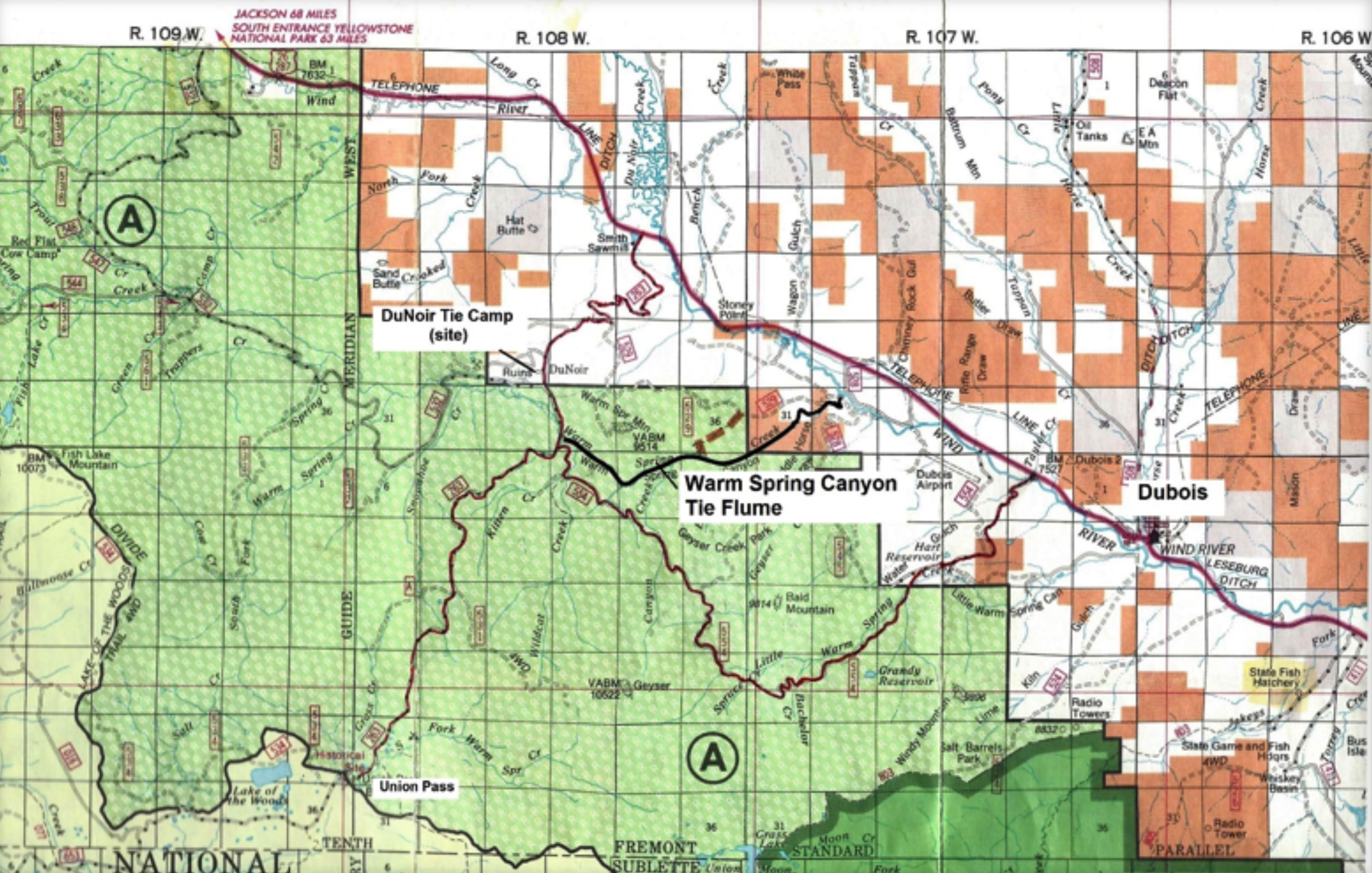
Built to carry railroad ties from camps high in the Wind River Mountains to the tie plant in Riverton, the flume still clings to the steep walls of Warm Spring Canyon, a rugged and isolated cleft in the mountains about four miles west of Dubois in northwest Wyoming. Remains of the flume can still be viewed by those willing to maneuver the rocky bed and cliffs of Warm Spring Creek.
The five-mile V-shaped wooden flume begins southeast of the Union Pass Road in the Shoshone National Forest and ends a short distance west of the Wind River on the old Harrison/Wagon Box Ranch. Though rock slides and tree falls have breached short segments of the flume, remnants can be traced along its entire length. Its overall physical integrity is remarkable, considering the erosive forces at work since 1942, when the flume was finally abandoned.
From lodgepole to railroad tie
From the 1860s until the early 1940s, hand-hewn crossties were the basis of the railroad tie industry. Some 2800 ties were needed for each mile of track, so a large and inexpensive supply was critical. Lodgepole pine grew in abundance in all the major mountain ranges of Wyoming -- straight and tall with gradual taper and a trunk relatively clear of knots. A sixteen-inch diameter lodgepole could yield up to six crossties.
An efficient method of tie production evolved. Lumbermen who hewed railroad ties were known as tie hacks; many had honed forestry skills in their native Scandinavia. Each tie hack was allotted his own strip of timber, about 150-200 feet wide and up to one-half mile long. First, he felled a suitable tree with a one-man crosscut saw, then limbed it with a double-bitted ax, which was also used to score the surfaces to be hewn—making two flat sides on opposite sides of the tie. A seven-pound broadax with a ten-to-twelve-inch blade was used to hew the wood to the final dimensions. A finished surface hewn by a skilled hack appeared to have been planed. The bark was then removed with a “spud” or “spud peeler,” a long wooden-handled tool with a curved blade on one end.
The tie hack dragged the finished ties to a strip road with a pickaroon, an ax-like tool with a metal point on one end, and stacked them along the road five high, with at least 25 ties to a stack. A competent hack could hew 25 ties per day; some were known to hew 50 or more. (Over time, virgin stands of timber became scarcer, challenging that level of efficiency.)
Enter the tie haulers. With a team of horses and a 16-foot sled called a “go-devil,” they could carry fifty ties per trip. They worked the strip roads, interconnected with main roads throughout the cutting area, moving the ties to landing banks to await the spring thaw and tie drive.
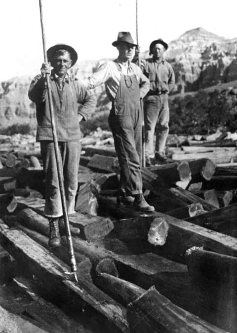
Tie drives–floating the ties on fast-flowing streams—were the climax of the season. So-called splash dams were built near the headwaters of the smaller streams in late spring. As the snow began to melt, the dams were closed at night, storing water to be released the next day and flushing the ties downstream. Jams were broken up with pike poles and pickaroons. Most tie-cutting areas were laid out around a major central stream or river, where the ties from various tributaries were gathered and driven downstream to major shipping points, such as railroad crossings or railroad towns like Riverton, where tie-treating plants were located.
Men called river rats waded ice-cold water, moving the ties steadily downstream and steering them clear of rocks, islands, or other obstructions. Lead gangs preceded the main drive in order to keep ties from floating into side channels, sloughs, and low spots. The drive cook and his flunkies provided huge meals and set up the night camp, where tepee tents sheltered two men each. Wagons (and later, trucks) hauled food and supplies, keeping pace with the drive downriver. Meals and fresh bread were baked in Dutch ovens placed in hot coals; on occasion, the men were treated to T-bone steaks.
Ties from the Upper Wind River
During the late 1800s, the Chicago and North Western Railroad expanded westward across the Great Plains. Tracks were laid through long stretches of generally unsettled land, luring emigrants and creating towns along the line. The C&NW reached Wyoming Territory in late June 1886 and extended west along the North Platte River Valley, reaching Casper by 1888 and the Shoshone-Riverton area by 1905. The Wind River Indian Reservation had just opened 1.4 million acres to homesteading; a large irrigation project and the extension of the railroad led to the creation of the town of Riverton, where the railroad crossed the Wind River.
The C&NW maintained nearly 700 miles of track between Lander, Wyoming, and Blunt, South Dakota. The Wind River Timber Company of Riverton was established to supply this section with 500,000 crossties per year. The company planned to cut ties from the forests about 100 miles upstream from Riverton and float them to a tie-treating plant to be constructed by the railroad.
Late in the fall of 1913, a crew of twenty workers headed to the timber northwest of Dubois. They built a base camp and began cutting ties in February 1914, first along Sheridan Creek and later DuNoir Creek on the north side of the Wind River. By March, forty-five tie cutters were at work; river crews prepared for the first tie drive, cutting and placing logs along the Wind River to hold the ties in the main channel. Three gangs of men worked with teams of horses below Dubois, dynamiting boulders out of the river bed to create a clear channel.
Early that summer, workers drove 35,000 ties downstream to Riverton. The local newspaper described the first drive: “This drive was more of an experiment than anything else and it removes all doubt of the complete success of the undertaking. The next thing in order will be the building of the pickling [preservative] plant, which probably will not be done until next spring.” The treatment plant was laid out in the southern part of Riverton along the Wind River; it was completed in 1915 and began full production the next year. By then, the Wind River Timber Company had been bought by the Wyoming Tie and Timber Company.
“A big job is underway”
In 1919, the company planned to cut ties in the Warm Spring Creek area near the Union Pass Road on the south side of Wind River. Martin Olson, the woods boss, guided Ricker VanMetre, later president of the company, over the region and convinced him that the ties could be successfully transported from this rugged, isolated location.
Long before the flume was built, locals knew the steep and dangerous nature of Warm Spring Canyon. In the early 1900s, settler Olney O. “Ollie” Green was caught in a storm while riding home from the high country near Union Pass. In the thick fog, he turned his horse down Warm Spring Canyon, not realizing his mistake until he could no longer turn back.
He managed to ride and lead his horse most of the way down to the area of two natural bridges formed by Warm Spring Creek, near the end of the treacherous canyon. Near dark, he tied his horse to a tree and hiked out. The next day he returned with some ranch hands and rescued his horse from the canyon bottom with slings and block and tackle.
During the 1920s, the challenges of the terrain became evident. Floating the ties from the cutting area to the Wind River below would necessitate building a flume down Warm Spring Canyon, considered a nearly impossible feat.
To access the cutting area, Martin Olson laid out a steep switchback road up from the Wind River valley, completed in 1925. Finally, in 1928, headquarters for the tie cutting operation were established in a meadow along upper Warm Spring Creek; it was known as the second DuNoir. The Courier Dubois announced on May 19, 1928 that work building the new tie camp would start soon, “as will also the construction of the gigantic flume which will carry the ties over the natural bridge.”
Headquarters camp consisted of a company store, company office, post office, schoolhouse, blacksmith shop, hay barns, storehouses, and housing for a dozen families, who paid $14 per month. Tie hacks lived in outlying camps near the cutting sites. Total cost of the headquarters camp, auxiliary camps, roads, and the flume was estimated at $125,000.
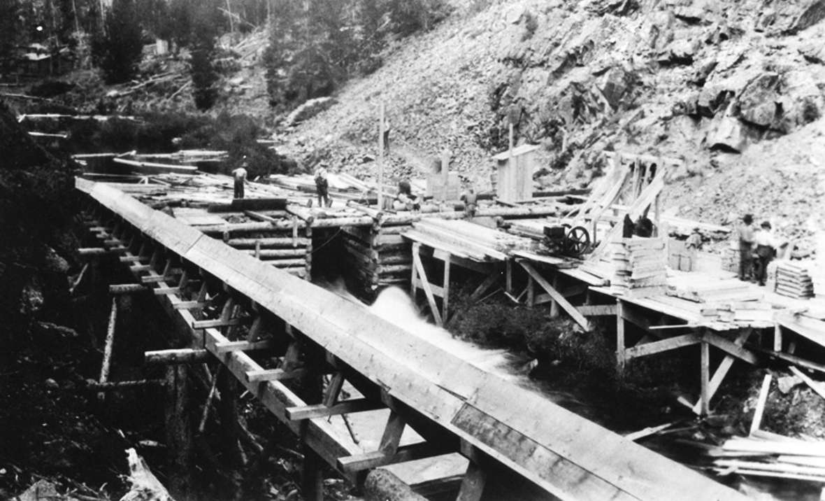
Martin Olson designed the proposed flume, and it was built in the summer and fall of 1928 by an engineering firm from Spokane, Washington, one section at a time from the top of the canyon down. Materials were floated down each completed segment for use in the next section.
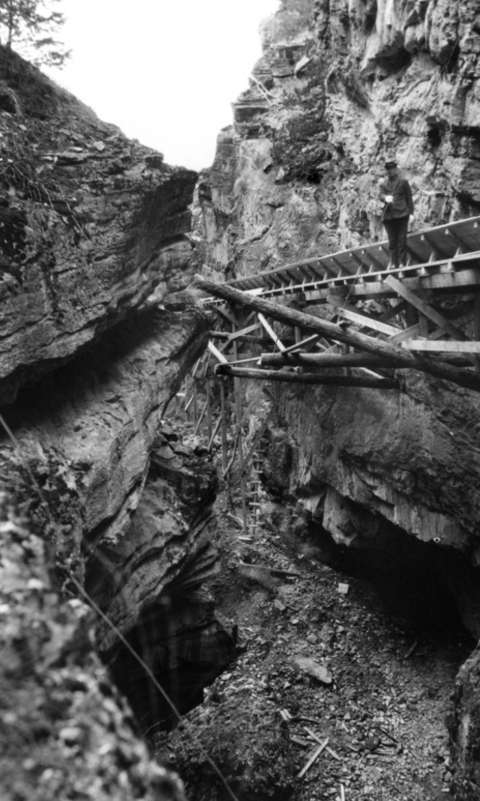
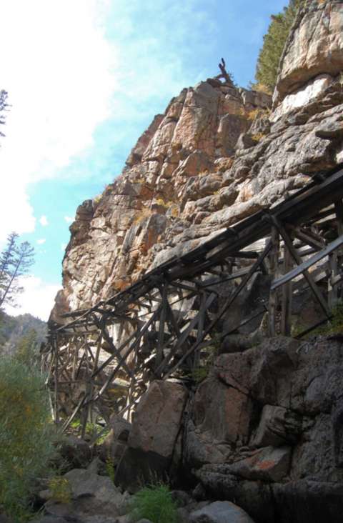
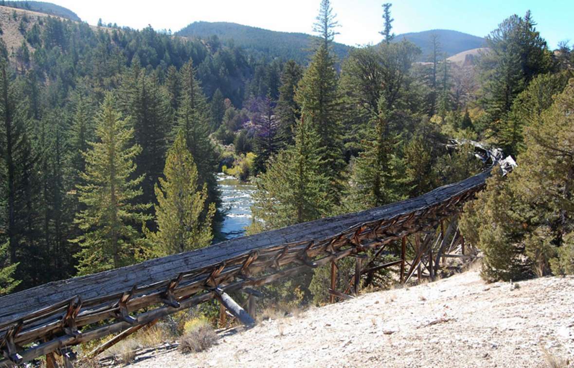
The V-shaped flume was supported by wooden trestles or stilts. To maintain an even grade, the height of the flume varied—on the more level areas it rested nearly on the ground, but along steep canyon walls the trestle was over thirty feet high. In places, the flume was suspended from steel cables anchored to eyebolts drilled into the sheer rock canyon walls.
A wooden walkway or catwalk was built along the flume for workers to manage the ties as they floated down. A telephone line ran along the flume for communication. The east end of the flume passed over one natural bridge and through a second. Feeder flumes were constructed along three tributary creeks, and others augmented the flow of water to parts of the main flume. A large holding dam was built at the west or upper end of the flume to hold the ties. In the spring of 1929, some 300,000 ties were funneled into the mouth of the flume and flushed down the canyon.
One man’s tie drive, 1937
Mark Goodman, a college student from Minnesota, worked the later years of the tie drives. The drive began at DuNoir, where the men camped in tepee tents along Warm Spring Creek above the holding dam. Tie hacks made up about one-third of the laborers; the rest consisted of local seasonal workers and a few college students who could earn their tuition in a short time. Average wages at the time were $2.00 per day, but during the 1937 tie drive, Mr. Goodman earned $4.50 a day, including meals. The workers supplied their own tents and bedrolls. Most purchased Bergman boots made in Sweden for nineteen dollars at the company store. The boots had thick soles and heels that held tungsten steel caulks for maneuvering on wet, slippery ties. Each man wielded an eight-foot long pike pole with a sharp point for pushing ties and a barbed hook for pulling them. The task was daunting – thousands of ties were piled up behind the holding dam and on stream banks, ready to be dragged by hand down to the water.
Goodman recalls that some of the men, seeking relief from the monotonous labor, would drive the twenty miles to Dubois for carousing, returning to their tents well after midnight. Ignoring the “roll out” call the next morning, they would be rudely awakened when someone yanked out the tent poles and their tents collapsed on them. Sometimes punishment included a pummeling with knees; this practice led to few men lingering in their tents after a hard night out.
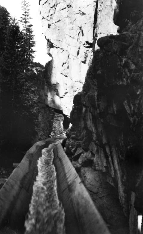
To start the ties down the flume, men with pike poles guided and turned the ties lengthwise as they entered the flume gate. The V-shaped flume was about five feet wide at the top and full of fast-flowing water, carrying the ties down as fast as fifty miles per hour. Up to 4,000 ties were floated down the flume in an hour. A break in the flume meant that hundreds of ties could spill to the bottom of the canyon. Workers manning the catwalk would telephone the flume gate operator, and the flume was shut down until repairs were made. When such a break occurred in the natural bridge, some 1,500 ties spilled into the creek. Workers hauled them up a steep path by hand and dumped them back into the flume.
The Warm Spring portion of the tie drive lasted about three weeks; workers were then transferred to the Wind River for the rest of the tie drive to Riverton. A large boom was constructed across the river at the Riverton tie plant to catch and hold the ties; from there, two conveyors carried the ties to the tie yard for sorting, stacking, and drying. Rejects were culled and sold for firewood or building material.
A “dinky” or small steam locomotive carried the dried ties to the boring mill, where small holes were drilled to help the preservative penetrate the ties. They were then hauled to the retort, where they were treated with zinc chloride, which doubled the life of the tie. They were finally transported to a loading dock, then into rail cars for shipment.
The Wyoming Tie and Timber Company and the tie treating plant in Riverton boomed during the 1920s. The operation peaked in 1927 when 700,000 ties were driven down the Wind River. In August 1928, the Courier Dubois announced the “annual tie drive fiesta” in Riverton, which would begin when the tie drive reached town. “A band is usually on hand to provide plenty of music, and the townspeople flock to the yard where a big feed is given. There is a free movie and dance for the drivers.”
Mechanization in the 1930s brought big changes to the tie industry. Portable sawmills gradually replaced tie hacks and broadaxes. The Warm Spring Canyon flume was abandoned in 1942 and never used again. Starting in 1943, ties were transported down from the mountain by truck, stacked along the Wind River, and then pushed into the river by bulldozers. During World War II, the tie-cutting operation faced a manpower shortage as the demand for ties increased. Although some local residents were hired, the problem was solved when VanMetre secured the assistance of an entire German prisoner of war contingent housed in 1944 at one of the upper tie camps.
The final tie drive on the Wind River was held in 1946, and all 150,000 ties came from sawmills. Between 1914 and 1946, some ten million railroad ties had been treated at the Riverton tie yard. In 1947, the Wyoming Tie and Timber Company was sold to J.N. Fisher, a Wisconsin businessman. Roller-bed trucks hauled ties from the woods to the treating plant on a year-round basis.
This system provided steady employment and a monthly payroll from the tie-treating plant built and owned by the railroad. The Riverton plant was modernized and used creosote rather than zinc chloride, increasing the serviceable life of the railroad tie from seventeen to thirty-five years. It continued to operate until 1969. Tie cutting in the Wind Rivers had come to an end.
Remnants of the flume today
The writers surveyed the Warm Spring Canyon Flume in 2010 for the U.S. Bureau of Land Management. The flume begins near the bridge crossing on the Union Pass Road, where the Warm Spring Creek valley is wide and relatively level. Remains of the holding dams are located a short distance southeast of the bridge and consist of three rectangular-shaped log cribs filled with rocks. These cribs anchored the dam, which consisted of boards and steel cables. The dams were equipped with a central sliding floodgate opened to regulate water level. A second gate on the north side allowed ties to be loaded into the mouth of the flume.
Below the dams, the creek narrows and enters the canyon. About 100 yards downstream, one first glimpses the flume. The overall configuration, a V-shaped trough on wooden stilts, remains consistent throughout the canyon; the height of the supporting trestles varies greatly according to terrain. Overall, some portions of the flume have rotted and collapsed or been destroyed by rockslides. In places, lodgepole pine and spruce trees have grown up through the structure. However, it is generally intact.
About three miles east of the Union Pass Road, the flume crosses from National Forest to Bureau of Land Management ownership. Access from the southeast is via a series of two-track roads and the Geyser Creek Trail. Two natural bridges are located in this area. The flume was built above the first (western) natural bridge, which has been impacted by falling rock and trees. The flume crossed from the north to the south side of the canyon—the north wall is so steep that eye bolts were driven into the cliff face, and the flume was suspended from steel cables anchored to the bolts. Remnants of the flume cables and some of the flume timbers still hang from the north cliff, but most of the flume here has been destroyed.
Both the flume and the creek pass though the more easterly natural bridge, a cavern almost 100 yards long, then emerge through the natural opening on the northeast side. Inside are travertine deposits in the shape of stalactites and stalagmites. The flume has been completely encased in travertine where it entered from the west side. The structure was once suspended from eye bolts and steel cables that hung from the roof and north wall. Collapsed wooden remnants of the flume can be seen at the downstream opening of the cavern.
East of the natural bridges, the flume is remarkably intact along a steep cliff face, elevated on wooden stilts 20 to 30 feet above Warm Spring Creek. This is one of the most spectacular remnants of the entire flume structure. Where the topography becomes more level, the flume enters private land owned by the Harrison Wagon Box Ranch and is currently not accessible to the public. The flume once continued southeast to its junction with the Wind River, but the remnants were probably salvaged for ranch use, and no physical remnants were found.
Legacy of the tie industry
The railroad tie industry made a significant contribution to the economy of Wyoming from the late 1800s through the early to mid-1900s and aided the expansion of railroad lines throughout the region. The railroads stimulated settlement and development of natural resources by linking Wyoming to distant markets. These rail lines could only be maintained by a constant source of locally available replacement ties.
The tie industry required a substantial work force and provided steady jobs and income, both in the mountains and at the Riverton plant. The crews were expanded during the spring/summer tie drives and provided much needed income to unskilled laborers, including ranchers, Native Americans and even college students. This industry was also composed of a significant foreign-born skilled work force, generally Scandinavian, who enhanced Wyoming’s ethnic diversification.
The Warm Spring Canyon Flume represents a uniquely engineered wooden structure. It is a testament to the superior design and construction of the Warm Spring Canyon Flume that so much of it remains intact.
Resources
Primary sources
- “All Doubt Removed; Tie Treating Plant to Locate at Riverton.” Riverton Republican, Riverton, Wyoming, 13 June 1913:1.
- “Celebration at Tie Camp Proves Year’s Big Event.” The Courier Dubois, Dubois, Wyoming, 10 November 1928, p. 7.
- “Five Mile Flume Being Built Thru Warm Springs Canyon by the Timber Co.” The Courier Dubois, Dubois, Wyoming, 4 August 1928, p. 5.
- “News Items.” The Riverton Review, Riverton, Wyoming, 13 March 1914:6.
- “River is Jammed with Ties, Logs, Props, and Fence Posts.” The Riverton Review, Riverton, Wyoming, 4 September 1914:1.
Secondary sources
- Dickson, Bly. “Retired Forest Employee Reveals Old Flume History.” Sheridan Press, Sheridan, Wyoming, 12 July 1967.
- Goodman, Mark. From the Broadax to the Railroad Tracks. Privately published in cooperation with the Wind River Historical Center, Dubois, WY. 2002.
- James Gores and Associates, Historic Warm Spring Flume Dubois, Wyoming Draft Assessment Report Condition Assessment. Report prepared by James Gores and Associates, P.C., Riverton, Wyo. and on file at the Bureau of Land Management, Lander Field Office, Lander, Wyo., 2002.
- Lepponen, Peter, retired Union Pacific Tie Inspector, Walden, Colorado. Interview, 6 June 1982.
- Massey, Rheba. Wyoming Comprehensive Historic Preservation Plan. Prepared for Archives, Museums and Historical Department, Wyoming SHPO, Cheyenne, 1989.
- Moline, Nels A. retired tie hauler, Saratoga, Wyoming. Interview 4 April 1982.
- National Park Service. How to Apply the National Register Criteria for Evaluation, National Register Bulletin No. 15. U.S. Department of the Interior. National Park Service, Washington, D.C.: Government Printing Office, 1991.
- Pinkerton, Joan Trego. Knights of the Broadax: The Story of the Wyoming Tie Hack. Caldwell, Idaho: Caxton Printers, Ltd., 1981.
- Rawlings, Charles. Our Neck of the Woods: Memoirs of a Pioneer Banker. Casper, Wyoming: Hawks Book Company, 1964 (reprinted 1994).
- Sintek, Skylar Scott. An Historical Overview of the Tie Treating Plant and Yard, Riverton, Wyoming. Report prepared for ARIX Corporation, Riverton, Wyoming, and on file at the Wyoming State Historic Preservation Office, Cheyenne, 1981.
- Wroten, William H. Jr. “The Railroad Tie Industry in the Central Rocky Mountain Region: 1867-1900.” Unpublished Doctoral Dissertation, Department of History, University of Colorado, Boulder, 1956.
- Wyoming Public Television. Brotherhood of the Broadax: Wyoming Tie Hacks (DVD). KCWC-TV/Wyoming Public Television, Riverton, Wyoming, 2005
Illustrations
- The black and white photos are all from the Wyoming State Archives. Used with permission and thanks.
- The color photos are by Elizabeth Rosenberg. Used with permission and thanks.
Field Trips
- Exhibits at the Dubois Museum, below, include artifacts from the lives of tie hacks and river rats.