Reshaw’s Bridge
Perhaps the greatest volume of traffic in westward migration in the 19th century was created by the California Gold Rush of 1849. One of the most popular crossings of the North Platte River that year for travelers on the Oregon/California/Mormon Trail was at a location just east of modern day Casper, Wyo. This ford, used by many earlier travelers including John C. Frémont, was commonly called the Old Indian Ford, but following its extensive use in 1849 this place became known as The California Crossing.

During the fall of 1852, an experienced mountain trader named John Baptiste Richard, along with Joseph Bissonette, Charles Bordeaux, Louis Guinard and William Kenceleur, began building the first successful bridge to span the North Platte River. Earlier bridges, built just a few years before, were dismal failures destroyed by spring flooding. This bridge was constructed only a quarter of a mile above The California Crossing and, until 1860 was known simply as The Bridge or Platte Bridge.
Because Richard spoke with a thick French accent, most travelers of the day mistook the pronunciation of his name, thinking it was Reshaw. As a result, the bridge became widely known as Reshaw’s Bridge. When Louis Guinard later built another bridge a few miles upstream, his crossing was called Guinard’s Bridge or Upper Platte Bridge, and Reshaw’s Bridge was sometimes referred to as Lower Platte Bridge.
Early descriptions
John Richard employed Joseph McKnight at the bridge for several years. McKnight described the bridge as follows:
The new bridge was built on several wooden piers, made of heavy timbers in a diamond shape to divert the water around them; they were then filled with rock for stability. The north abutment was a sandstone cliff that rose several feet above the high water line. The south end of the bridge was slightly lower as it extended some distance to meet the sloping prairie. To further strengthen the piers they were cross-timbered internally before the rock was added. These piers were thirty to forty feet apart and spanned by logs hauled from the mountain, seven miles to the south. After all had been braced, stayed, and fastened together with iron bolts, the deck was laid. Made from four-inch thick hand-sawn planks, each was hand fit tightly together and spiked to the span logs. Afterward a heavy railing was installed to prevent livestock from drifting over the side. This railing carried extra bracing at each of the piers to further strengthen the structure.
The completed bridge overall was about a thousand feet long and between 15 and 18 feet wide. According to McKnight, the bridge cost $40,000 to build.
When J. R. Bradway crossed the bridge at the end of June 1853, Richard charged eight dollars per wagon. Bradway also reported a coal mine in the north bank of the river that Richard used to fuel the fires in his blacksmith’s shops and to heat his home and his other business enterprises at the bridge. Bradway left a letter and a portion of his journal to be sent back home with Richard, another valuable service Richard performed for customers. Bradway’s journal would travel east with the next eastbound traveler that happened along.
On July 1, 1853, when Dr. John Smith arrived at the bridge, he was charged six dollars to cross his wagon. Richard told Smith that so far that season 3,000 wagons had crossed the bridge.
Richard’s tolls and the tolls of other bridge proprietors generally rose and fell with the water level in the North Platte; when the water was highest—generally in June—his bridge was protecting travelers from the greatest risk and therefore he could charge the highest prices. In those years long before the river was dammed, the river level fluctuated dramatically; by midsummer the water was low enough that the river was easily forded, and so Richard’s prices fell in an attempt to get at least some of the business.
On Nov. 2, 1853, J. Soule Bowman passed on to the public the first published statement by any party who had actually seen the bridge. He reported to the Missouri Republican that at a point 150 miles above Fort Laramie, “a substantial bridge has been erected over the river at which emigrants can cross their stock in safety, and at a fair price.” His distance may have been off by a few miles, but other bridges had been advertised as “substantial” and were washed away before the emigrants could get there to use them. Here was a bridge that withstood the spring floods of 1853 and would likely be there for those who would make the trip across the trail next year.
The Army
In 1855, a detachment of soldiers was stationed at the bridge to protect it from American Indian threats. By the next year, the military unit had grown to a full company complete with three officers and a bugler. Capt. Henry Heth commanded this unit. A mountain howitzer would soon be added to increase their strength.
In February 1856, the encampment acquired the name of Camp Davis, in honor of Jefferson Davis, then President Franklin Pierce’s secretary of war and later president of the Confederacy. The North Platte’s water was high, emigrant trade was good and, in addition to bridge tolls, John Richard was enjoying a fair amount of trade from the soldiers of the 10th Infantry at Camp Davis, only a few hundred yards from his trading post.
J. Robert Brown, an employee of a westbound trading company that arrived on July 5, 1856 and remained a few days for repairs, wrote of Reshaw’s Bridge in his journal: “There are several very good log buildings here; these are used as a store, dwelling houses for the traders, blacksmith shop, etc. There are about thirty lodges belonging to the Crows and Sioux, the soldiers live in lodges also; there are only fifty-eight of them here now.” Brown claimed that Richard and his brothers “made over $200,000 apiece” from operations of the bridge and the trading post.
Several diarists mentioned the bridge and trading post in 1859. Hammet Hubbard Case crossed what he considered a stout timber bridge on June 12 and referred to 15 or 20 “comfortable” log homes that stood nearby. J. A. Wilkinson crossed the bridge that same day. He surmised that the construction of such a structure over such a swift river as the Platte must have been quite a costly project. He also ventured into the trading post, where he was amused by the efficiency of Richard’s clerks, who bartered with Indians in sign language.
Capt. Raynolds
On Oct. 11, 1859, Capt. William F. Raynolds of the U.S. Army Corps of Topographical Engineers arrived from the north at the Oregon Trail near Red Buttes, a few miles west of what’s now Casper. With a 30-man infantry detachment and Jim Bridger as guide, Raynolds had been exploring the Powder River Basin and the country around the northern end of the Bighorn Mountains, and had come south to the North Platte to find a more comfortable place to spend the winter.
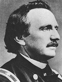
When he saw the famous thoroughfare, Raynolds realized for the first time the size and significance of the westward migration. Raynolds found the volume of traffic on the road astonishing, even so late in the season. He was further amazed when he discovered that there was about the same amount of eastbound as westbound traffic, and he was seldom out of sight from some vehicle traveling one direction or the other “upon this great highway.”
Heading east from Red Buttes, Capt. Raynolds soon covered the 18 miles to Richard’s Bridge and Trading Post. When Raynolds arrived, John Richard gave him a 4-month-old letter and told him that there was more correspondence waiting for him 20 miles further east at the post office at Bissonette’s Trading Post at Deer Creek, near present Glenrock, Wyo. The captain enjoyed the best of Richard’s well-known western hospitality, and the extraordinary luxury of eating dinner at a table while sitting down.
Competition from Guinard, and the Pony Express
Around the time of Raynold's arrival, John Richard's former partner, Louis Guinard, contracted with Joseph McKnight to build a new bridge across the Platte a few miles upstream from Richard’s.
William Russell of the well-known freight company of Russell, Majors and Waddell spent several months lobbying Congress to promote the Platte River Route for mail service to California for what would soon become the Pony Express. Russell believed the Platte Route was far superior to the much longer southern route of the Overland Mail Company through what’s now Colorado, established originally to serve gold miners then pouring into Denver on their way to new diggings at Pikes Peak.
The freighters invested thousands of dollars establishing nearly two hundred relay stations along the proposed route for the Pony Express in 1859 and 1860. Joseph Bissonette’s Deer Creek operation was one of the selected sites. John Richard’s trading post at Red Buttes was also on the list, but Louis Guinard’s new bridge was chosen over Richard’s Bridge for the crossing of the Platte and, consequently, the relay station. In April 1860, the inaugural run of the Pony Express was set into motion. By July, Russell’s political efforts and demonstration paid off and the entire venture received final federal approval.
The Richard brothers
The business interests of John Richard and his brothers Joseph and Peter by this time stretched from the North Platte to New Mexico. They shipped whiskey from Taos north to Pikes Peak miners and Oregon Trail travelers, and ran a brisk trade fattening emigrants’ exhausted cattle and selling them to emigrants at John Richard’s bridge.
Richard also at this time employed more than 20 Indian women at his trading post, making buckskin clothing, moccasins and other Indian items that could be sold to emigrants and to the miners down in Colorado—perhaps Wyoming’s earliest industry.
Sir Richard Burton, world traveler
Russell, Majors and Waddell also owned the stagecoach line, the Central Overland, California, and Pike’s Peak Express Company, which also used the North Platte route. A famous passenger, author, world traveler and explorer of East Africa Sir Richard F. Burton, stopped at Richard’s bridge in August 1860 en route to Utah and California.
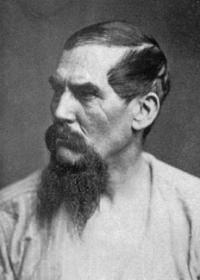
Burton’s observations shed considerable light on John Richard, his bridge and the community that surrounded it. Enjoying a glass of whiskey in Richard’s “indispensable store,--the tete-de-pont,” [bridgehead] he was surprised to have the drink served “on ice,” the first he had seen in weeks. Surprisingly, Burton, who spent a considerable amount of time in France and was an accomplished linguist, also misspelled Richard as “Reshaw.”
Burton referred to the settlement adjoining Richard’s Bridge as a town. Nearby, though, the then-vacant army “Post at Platte Bridge” had deteriorated to “a few stumps of crumbling wall, broken floorings, and depressions in the ground.”
Burton left Richard’s to spend the night at the COCPP station at Guinard’s Bridge. Louis Guinard and his Shoshone wife, who operated the station, met him there. He was unimpressed by their hospitality and accommodations and disgusted by the meal.
Wishing he had eaten at Richard’s instead, Burton made this comment; “It was impossible to touch the squaw’s supper; the tin cans that contained the coffee were slippery with grease, and the bacon looked as if it had been dressed side by side with ‘boyaux’ [intestines; perhaps sausage]. I lighted my pipe, and air-cane in hand, sallied forth to look at the country.”
Bridge decay
The last small boom for the community occurred in 1864 when Richard’s Bridge became a jump-off point for travelers heading north to the Montana gold fields on the Bozeman Trail. By the following year, however, shortcuts were established to the Bozeman Trail from points further east on the North Platte—Deer Creek and later Fort Fetterman.
Long before the famous Battle of Platte Bridge near Guinard’s Bridge in 1865, John Richard had left the area and moved more than 100 miles to the south to Rock River on the new Overland Trail, which by then was carrying most of the transcontinental traffic.
Richard and his family still owned the bridge and trading post on the North Platte, but it was only occupied seasonally by traders in Richard’s employ. During the severe winter of 1865-1866, soldiers at the new Fort Casper—adjacent to Guinard’s Bridge—dismantled Richard’s Bridge and many of the nearby buildings for firewood and building materials.
In 1867, Fort Casper was dismantled and its building materials were moved to expand Fort Fetterman, 50 miles east down the North Platte. Following the abandonment of Fort Casper and Richard’s Bridge, no record of habitation in the area exists for several years. Completion of the transcontinental railroad across what’s now southern Wyoming in 1869 ended nearly all long-distance transcontinental travel along the North Platte route.
When James H. Bury, later a longtime resident of Casper, first passed the site of the old fort in the early 1870s, he saw only the charred remains of the old Fort Casper adobe trading post. An important era of transportation-based prosperity on the Upper North Platte River had come to an end.
Resources
Primary Sources
- Bradway, J. R. Diary. Library of the State Historical Society of Wisconsin, Madison, Wisc., 43.
- Brown, J. Robert. Journal. Western Americana Collection, Beinecke Rare Book and Manuscript Library, Yale University Library, New Haven, Conn.
- Coutant, C. G. Papers. Coutant Collection, Box 4, Folder 53, book 36.Wyoming State Archives, Cheyenne, Wyo.
- Cragin, F. W. Papers. Colorado Springs Pioneers Museum, Colorado Springs, Colo. Interview of William T. Eubank on Aug. 18, 1908 at Denver, Colo., Notebook I, 5/25, 6/26.
- David, Robert. Interview of James H. Bury, 1920. Bob David Collection, Casper College Western History Center, Casper College, Casper, Wyo.
- Raynolds, Capt. William F., Report on the Exploration of the Yellowstone River. Washington, D.C.: United States Army Corps of Engineers, 1868, 70-72.
- Ricker, Judge Eli S. Interview of Magloire Alexis Mosseau, Buzzard Basin, Pine Ridge Reservation, S.D. Oct. 30, 1906, tablet 28, 16-20. Ricker Collection, Nebraska State Historical Society Library, Lincoln, Neb.
- Smith, Dr. John. Diary 1853. Huntington Library, San Marino, Calif.
Secondary Sources
- Bryans, Bill. Deer Creek: Frontier Crossroads in Pre-territorial Wyoming. Glenrock, Wyo.: Glenrock Historical Commission, 1990, 61, 118-121.
- Burton, Sir Richard F. The City of the Saints and Across the Rocky Mountains to California. Edited by Fawn M. Brodie. New York: Alfred A. Knopf, 1963, 154-156.
- Doyle, Susan Badger, Ph.D. “The Bozeman Trail, 1863-1868.” Annals of Wyoming, 70, no. 4 (Spring 1998): 70.
- Franzwa, Gregory M. Maps of the Oregon Trail. (Gerald, Mo.: Patrice Press, 1982), 117.
- Glass, Jefferson. “Crossing the North Platte River: A Brief History of Reshaw’s Bridge, 1852-1866.” Annals of Wyoming 74:3 (Summer 2002): 25-40.
- ______________. Reshaw: The Life and Times of John Richard, Extraordinary Entrepreneur and Scoundrel of the Western Frontier. Glendo, Wyo.: High Plains Press, 2014.
- McDermott, John D. “John Baptiste Richard,” The Mountain Men and the Fur Trade of the Far West, ed. LeRoy R. Hafen. Glendale, Calif.: Arthur H. Clark, 1965 vol. 2, 289-290, 294-296.
- McDermott, John D., Frontier Crossroads: The History of Fort Caspar and the Upper Platte Crossing. Casper, Wyo.: City of Casper, 1997, 7-8, 10, 12, 20, 25, 88-89, 114.
- Mokler, Aflred James. History of Natrona County, Wyoming, 1888-1922. Casper, Wyo.: K. Hemry, 1989, p. 113. Accessed 5/21/12 at http://ia600407.us.archive.org/26/items/historyofnatrona00mokl/historyofnatrona00mokl.pdf.
- Nicholas, Thomas A. “A New Look at Richard's Upper Platte Bridge and Trading Post at Evansville, Wyoming.” Casper Star-Tribune, n.d. 1963.
- _________________. “Platte Bridge and the Oregon Trail in the Civil War Period - 1855-1870.” Casper Star-Tribune, Feb. 19, 1961, 14, 16-17.
- ___________________. “Timbers From Old Reshaw Bridge Found.” Casper Star-Tribune, Oct. 9, 1966, 4.
- Taunton, Frances B., ed. Sidelights of the Sioux Wars. London: English Westerners Society, 1967, 11. Brian Jones’ “Those Wild Reshaw Boys,” in Special Publication No. 2 was of special help.
Illustrations
- The photo of the replica Reshaw’s Bridge at Reshaw’s Park in Evansville, Wyo. is by the author. Used with thanks.
- The photos of Capt. William Raynolds and Sir Richard Burton are from Wikipedia. Used with thanks.
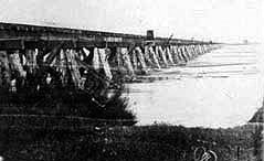 The photo at right is identified as a photo of Richard’s Bridge on websites maintained by the Wyoming State Historic Preservation Office and the Town of Evansville. But Richard’s and Guinard’s bridges were built on large, diamond-shaped piers made of horizontal logs, with the space inside the logs filled with rocks. This bridge is clearly built on pilings. It may well be the wooden wagon bridge built about a mile west of present downtown Casper in 1889 by the Northwestern Railroad, and described on p. 113 in Alfred J. Mokler’s History of Natrona County. That bridge was torn down in 1921.