Eisenhower’s 1919 Road Trip and the Interstate Highway System
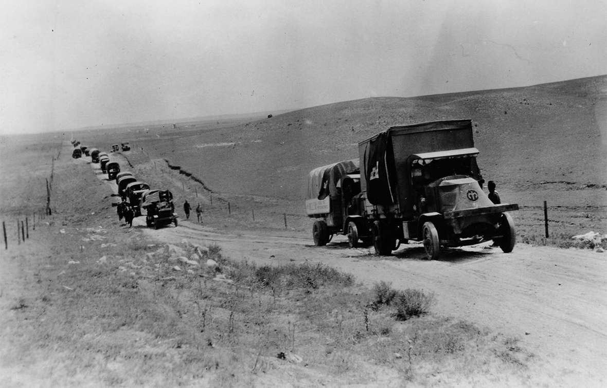
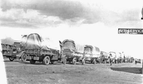
On Aug. 8, 1919, young Lt. Col. Dwight D. Eisenhower arrived in Cheyenne with a long line of military cars, trucks and motorcycles. The Transcontinental Motor Truck Convoy entered the city on the Lincoln Highway during an evening thunderstorm.
The soldiers had spent 11 hours on the road that day, traveling from Kimball, Neb., to Cheyenne. Today, drivers on Interstate 80 can easily make the 66 miles between Kimball, Neb., and Cheyenne in less than an hour.
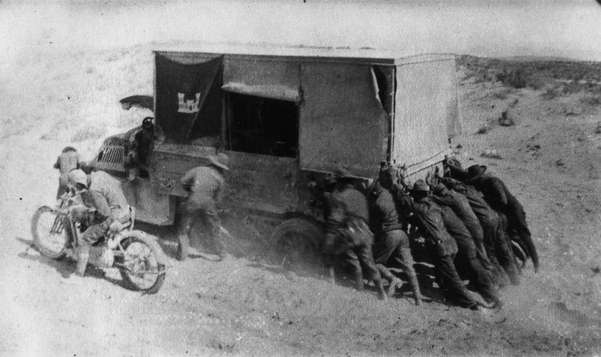
A few days before, on August 5, after leaving North Platte, Neb., the daily convoy log noted that many of the trucks had to be pulled through a 200-yard stretch of quicksand, resulting in a delay of seven hour and 20 minutes. A large, heavy truck called the Militor was able, after five unsuccessful attempts by other vehicles, to pull out one of the lighter trucks that had sunk into sand deep enough to cover both right wheels and its differential.
The purpose of the cross-country trip—never attempted before—was to determine the condition of the roads nationwide. The Cheyenne State Leader article explained that the 72 vehicles and personnel “showed signs of the road, but both were eloquent evidence of the efficiency” of the United States’ effort that helped win World War I the year before.
The push for better roads
The nation’s roads and efforts to improve them had long been a concern. “Since the late 19th century,” writes author Sarah Laskow, “the Good Roads Movement had been advocating for upgrades to the dirt and gravel tracks that connected cities to one another—and forming associations to finance and build them.”
Author Tom Lewis traced the Good Roads Movement to Albert A. Pope, a Union Civil War veteran who, in 1878, created a “safety bicycle.” Pope organized the League of American Wheelmen, which advocated better roads through a variety of efforts including financing road-engineering courses at the Massachusetts Institute of Technology. By 1900, according to Lewis, 300 companies produced more than a million bicycles per year, and “the ‘good roads’ movement was sweeping the country.”
In 1913, the Lincoln Highway, one of the earliest transcontinental highways for automobiles, was dedicated. The 3,400-mile highway route crossed 13 states from New York to San Francisco. For many years, however, it remained a route only—with roads that varied widely in their quality.
On July 16, 1916, Woodrow Wilson signed the first Federal-Aid Road Act into law. The act created the Bureau of Public Roads and allocated $75 million for next the five years, with federal funds to pay states half the cost for building or improving federal roads. At the time, there were more than 21 million horses, 3.5 million cars and 250,000 trucks in the United States, according to Lewis.
During World War I, troops drove new Army trucks and material from factories in the Midwest to Eastern ports where they could be shipped to Europe. In December 1917, the first convoy took three weeks to drive from Toledo, Ohio, to Baltimore.
Other factors also led to the push for better roads. Trucks, more convenient and better able to go more places, were gradually becoming competitive with trains as a way to move freight. But trucks weighed much more than automobiles, and their tires were solid rubber; paved roads crumbled under the wear.
By 1919, the BPR had spent only about a half million of the $75 million allotted, and only 12 and a half miles of roads had been constructed.
Ike’s 1919 journey
The members of the convoy that Eisenhower traveled with in 1919 discovered that the nation’s roads, especially those west of Nebraska, were in rough condition. The soldiers faced mechanical breakdowns, quicksand, and in Utah and Nevada, rationed food and water. They traveled more than 10 hours daily at an average speed of about 5 miles per hour. On some days, they covered as little as three miles.
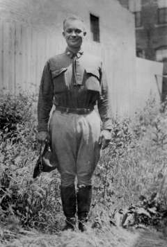
The convoy left Washington, D.C. July 7, 1919, to head for San Francisco. The caravan stretched for three miles. Eisenhower and his friend, Maj. Sereno Brett, had served as tank officers together during World War I. They were among the 24 officers and 258 enlisted men on the journey, accompanied by a 15-piece band courtesy of the Goodyear Tire & Rubber Company.
“In the Rockies of Wyoming and Utah and across Nevada, they went where few automobiles had gone before,” Lewis writes. The convoy log of the journey between Kimball and Cheyenne noted “The effect of altitudes exceeding 6000’ very noticeable in connection with the starting and operation of motors.”
On August 8, Gov. Robert Carey and a host of other dignitaries met the convoy at tiny Hillsdale, Wyo., 17 miles east of Cheyenne, to welcome them to the state. A wild west show was held in their honor at Frontier Park in Cheyenne. Following the show, the soldiers stopped at Fort Russell for a meal and the opportunity to bathe and rest. A dance was also held in honor of the visitors. In appreciation of the “distinctive” welcoming, the Leader report explained that the convoy would carry “cloth posters”—proclaiming “Stop Your Roaming, Try Cheyenne Wyoming”—and declaring that Wyoming was spending $7 million on roads.
Crossing Wyoming, the convoy encountered daily breakdowns and obstacles. Two-hour delays to repair mechanical problems were not unusual. The August 14 entry in the log noted the rough roads after departing Tipton Station west of Rawlins early in the morning. “Bad, sandy trail, very rough, with drop-offs over shelves of rock just below surface. 7 mi west a bad sandy stretch was negotiated more easily by F.W.D.s than other makes.”
Eisenhower noted in a November 1919 report about the trip that in addition to the Militor, which once pulled four trucks at one time, four-wheel drives (F.W.D.s), 2-wheel rear drive vehicles and Mack trucks with chain drives were among the vehicles that made the trip. Because the vehicles each operated at different speeds, keeping the convoy in formation was troublesome. Ike explained that the one-and-a-half ton Packard trucks performed in “remarkable” fashion throughout the trip.
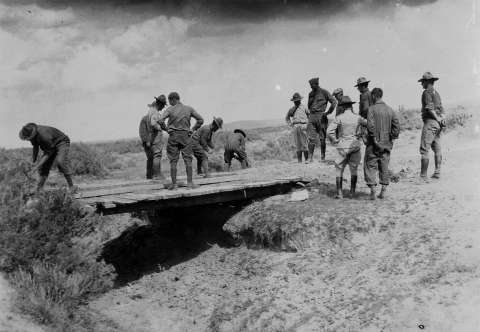
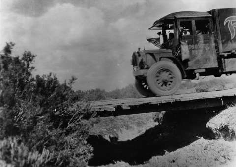
Much of their route across southern Wyoming was not on roads at all, but on the old Union Pacific right-of-way, abandoned after 1899 when the railroad had straightened its routes and improved its grades. The old route was often very winding, soft and sandy, with wobbly, rickety bridges and culverts the trucks broke through.
And although the soldiers were feted in towns at various stops along the way—a Red Cross canteen offered refreshments in Rock River, and the people of Medicine Bow put on a street dance—the daily routine was wearing. Dust choked up the carburetors, and unrelenting, bleak terrain was hard on the men. “The intensely dry air, absence of green trees and vegetation,” the log notes in its description of the stretch between Point of Rocks and Medicine Bow, “and parched appearance of the landscape exerted [a] depressing influence on personnel.”
The convoy left Evanston, Wyo. at 12:30 p.m. August 17 and crossed into Utah that afternoon.
Eisenhower joined the convoy “partly for a lark and partly to learn,” he wrote many years later. Ike recalled the time in Wyoming with fondness. His wife, Mamie, and her family, met the “truck train” in the middle part of Nebraska and traveled with them as far as Laramie, Wyo.
Ike recounted these stories in his 1967 book, At Ease: Stories I Tell Friends, in a chapter entitled, “Through Darkest America with Truck and Tank.”
Eisenhower and his friend Maj. Brett enjoyed playing some practical jokes along the way, especially enjoying the surprises they foisted on Easterners, like warning them of hostile Indian attacks in western Wyoming. No such attacks actually happened, of course. Another time, Ike “aimed the pistol in the general direction of the North Pole and fired,” to shoot a jackrabbit that he had shot hours before and that Brett posed beside a bush away from the road. Brett, to impress the Easterners, proclaimed what an excellent shot Ike was, holding the dead rabbit by its ears at a distance to disguise its stiff condition.
Hijinks aside, the 62-day journey stayed with Ike for years and impressed upon him the need for good highways throughout the nation.
Highway funding after World War I
In 1921, the Federal Highway Act increased funding for federal roads to $75 million per year. Lewis explains that by the end of the 1920s, the BPR had spent $750 million for roads. The 1921 act, he writes, “made real the idea of a national road system. Each state would designate seven percent of its roads to be linked with those in other states.” In the 1920s, the numbering system for U.S. highways began. The portion of the Lincoln Highway from Pennsylvania through Wyoming became U.S. Highway 30.
In 1922, the Bureau of Public Roads commissioned Gen. John J. Pershing, who had been a son-in-law of Wyoming’s U.S. Sen. Francis E. Warren, to draw a map that could be used for the construction of roads and also for the purpose of clarifying which roads would be most important for defense if the nation became involved in a war.
The “Pershing Map” became the first official topographical map of the United States. Pershing had commanded the American Expeditionary Force (AEF) on the Western Front during World War I. He also became a mentor to a number of other illustrious United States generals, including Dwight D. Eisenhower.
In the late 1930s, President Franklin Delano Roosevelt proposed routes for a transcontinental system of roads to the chief of the BPR, but World War II and then the Korean War interrupted the plans.
Lewis explains that 1953 was a turning point in American transportation history. Eisenhower, who had served as Supreme Commander of the Allied Forces during World War II, became the first Republican president elected in two decades, and he “brokered an armistice in Korea, thus enabling the United States to return to full peacetime production.”
More people could purchase cars than before. Between 1950 and 1960, Lewis writes, the number of families owning automobiles increased from 60 percent to 77 percent. During the same decade, the number of railway passenger cars decreased from 37,359 to 25,746. “Since 1936 [railroad] passenger operations had made a net profit only during the war when the government had curtailed automobile travel.”
By the time he became President of the United States in 1953, Eisenhower had driven on the German autobahns and had appreciated the ease and speed of travel on those highways. The 1919 transcontinental trek across the United States had convinced him that the nation needed better roads. He wrote, “The old convoy had started me thinking about good, two-lane highways, but Germany had made me see the wisdom of broader ribbons across the land.”
Lewis explained, “After V-E Day, when he traveled the autobahn, Eisenhower learned firsthand the value of modern highways to defense.”
By the time Eisenhower became president, the nation felt itself under threat of nuclear attack. An interconnected highway system could facilitate routine travel and could provide an efficient escape route in the event of an attack.
The National Interstate and Defense Highways Act of 1956
On June 29, 1956, Congress authorized the National Interstate and Defense Highways Act of 1956, approving $25 billion for the completion of 41,000 miles of highways within a decade. The interstate was the largest public works project approved in the nation’s history.
The Bureau of Public Roads eventually became part of the Federal Highway Administration, formed on April 1, 1967, as a part of the U.S. Department of Transportation.
The Pennsylvania Turnpike, a 162-mile stretch completed in 1940, became part of Interstates 70 and 76—one of the earliest interstate highways. However, in 1956, Missouri claimed to have been the state with the first contracts signed and Kansas claimed status as the first state to begin paving. Nebraska, on Oct. 17, 1974, became the first to complete all of its interstate highway system.
A treacherous stretch through Wyoming
In the late 1950s, the interstate was planned to run through a 77-mile section of Wyoming between Laramie and Walcott Junction. Despite objections from locals, Bureau of Public Roads officials determined to place the highway closer to Elk Mountain on a more direct route, rather than following the path of U.S. Highway 30—the Lincoln Highway—where it swings north through Rock River and Medicine Bow.
 Historian John Waggener writes, “After three years of debates, and after receiving no federal support for locating I-80 along U.S. 30, state highway officials accepted defeat. On May 15, 1959, the Wyoming State Highway Commission approved the direct route. All that they could do was delay construction while the rest of I-80 was completed across the state. Under pressure from the BPR after a seven-year delay, construction finally began in the summer of 1966.”
The stretch from Laramie to Walcott opened Oct. 3, 1970. Waggener writes, “On October 7, an early-season storm caused havoc for drivers on the new highway just as Wyomingites warned would happen. It took only four days for I-80 to become The Snow Chi Minh Trail [italics in original]”—a Vietnam-era nickname that, though fading, is still in use. The section has suffered a high accident rate and frequent wintertime road closures ever since it opened.
Nationally, the interstate system also took longer to complete than had been planned. Author Tom Lewis explains that it “took 40 years not 13 as specified by the legislation President Eisenhower signed in 1956 to build the Interstate Highway System.”
In 1991, the interstate, according to Lewis the “largest engineered structure in the world,” was named the Dwight D. Eisenhower System of Interstate and Defense Highways. On Sept. 12, 1991, Interstate 90 between Seattle, Wash., and Boston, Mass., became the final coast-to-coast interstate highway completed. Today, the interstate system consists of about 47,856 miles of completed highways, and in terms of 2016 dollars, the cost of construction was approximately $526 billion.
Resources
- “Daily Log of the First Transcontinental Motor Convoy, Washington D.C. to San Francisco, Cal., July 7th to Sept. 6, 1919.” Eisenhower Archives. Accessed Dec. 22, 2017, at https://www.eisenhower.archives.gov/research/online_documents/1919_convoy/daily_log.pdf.
- Distance between Cities. Accessed Dec. 2, 2017, at https://www.distance-cities.com/distance-kimball-ne-to-cheyenne-wy.
- “Eisenhower’s Army Convoy Notes 11-3-1919, Rock Island Arsenal.” U.S. Department of Transportation. Federal Highway Administration. Accessed Dec. 22, 2017, at https://www.fhwa.dot.gov/infrastructure/convoy.cfm.
- Eisenhower, Dwight D. At Ease: Stories I Tell to Friends. Garden City, N.Y.: Doubleday & Company, Inc., 1967, 155-168.
- Federal Highway Act of 1921. Wikipedia. Accessed Dec. 13, 2017, at https://en.wikipedia.org/wiki/Federal_Aid_Highway_Act_of_1921.
- “Federal Aid Highway Act of 1956.” Wikipedia. Accessed Dec. 15, 2017, at https://en.wikipedia.org/wiki/Federal_Aid_Highway_Act_of_1956.
- “Information about the Lincoln Highway.” Lincoln Highway Association. Accessed Dec. 13, 2017, at https://www.lincolnhighwayassoc.org/info/.
- “Interstate Highway System.” Wikipedia. Accessed Dec. 15, 2017, at https://en.wikipedia.org/wiki/Interstate_Highway_System.
- “John J. Pershing.” Wikipedia. Accessed Dec. 13, 2017, at https://en.wikipedia.org/wiki/John_J._Pershing.
- Laskow, Sarah. “In 1919, Eisenhower Suffered Through History’s Worst Cross-Country Road Trip.” AtlasObscura.com. Accessed Nov. 6, 2017, at https://www.atlasobscura.com/articles/in-1919-dwight-d-eisenhower-suffered-through-historys-worst-cross-country-road-trip. This article contains a link to the convoy log.
- Lewis, Tom. Divided Highways: Building the Interstate Highways, Transforming American Life. New York: Viking, 1997, 4, 7-8,10-11, 13,16,18-19, 50-51, 61,71-72, 81, 84, 86, 88-90, 98, 105, 107, 108, 112-113, 201, 294.
- “Lincoln Highway.” Wikipedia. Accessed Dec. 13, 2017, at https://en.wikipedia.org/wiki/Lincoln_Highway.
- Thompson, Helen. “How a Hellish Road Trip Revolutionized American Highways.” Smart News, Smithsonian. Accessed Dec. 16, 20117, at https://www.smithsonianmag.com/smart-news/1919-ike-took-hellish-road-trip-across-us-180956284/.
- “Trucks of Transcontinental Motor Convoy Cross the Continental Divide in Wyoming.” YouTube. Accessed Dec. 22, 2017, at https://www.youtube.com/watch?v=HRXkh_WjWBc.
- Waggener, John Richard. Snow Chi Minh Trail: The History of Interstate 80 between Laramie and Walcott Junction. Wheatland, Wyo.: Wyoming State Historical Society, 2017, 343-345.
- “Wild Western Reception Given Motor Convoy by Old Cheyenne.” Cheyenne State Leader, Aug. 9, 1919, 1. Accessed Dec. 13, 2017, at http://newspapers.wyo.gov.
For Further Research
Click here to see great film footage of the 1919 expedition in a recent episode of the French TV show “Invitation au Voyage,” featuring summertime Cheyenne, Frontier Days, and author Lori Van Pelt talking about Eisenhower’s journey.
Illustrations
- The photo of the convoy stopped in Rock River is from the Wyoming State Archives. Used with permission and thanks. The rest of the photos are from the Eisenhower Archives, via an article on mashable.com that offers large-sized versions of the photos. Used with thanks.